
Sardar Vallabh Patel International Airport
 Ahmedabad · Ấn Độ· Sardar Vallabh Patel International Airport
Sardar Vallabh Patel International Airport (IATA: AMD, ICAO VAAH) là một sân bay lớn phục vụ Ahmedabad, Ấn Độ.
Sardar Vallabh Patel International Airport is a large airport, at an elevation of about 189 ft, with scheduled passenger service. This page gathers its location map, airport codes and travel information.
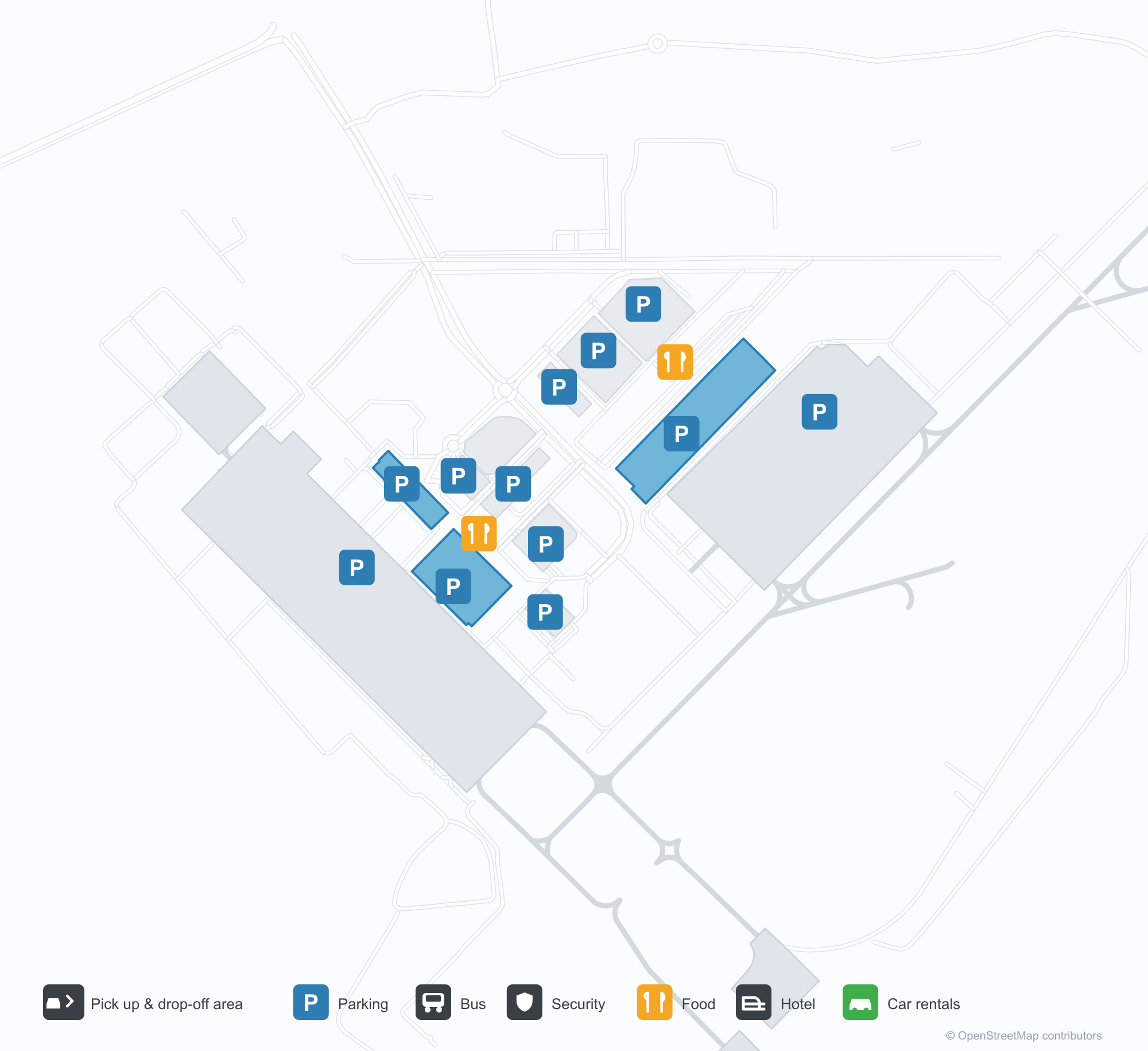
Tải bản đồ sân bayTải xuống
Ảnh sân bayẢnh sân bay
Ảnh thực tế của sân bay này, mỗi ảnh đều ghi nguồn từ trang web công khai nơi tìm thấy ảnh; bản quyền thuộc về nhiếp ảnh gia gốc. Nhấp vào ảnh để phóng to, hoặc nhấp vào dòng ghi nguồn để mở trang nguồn.
Nhà ga về đêm — ánh sáng tím phủ lên mái đua, các cột trên lề đường và tên sân bay bằng tiếng Gujarat dọc dải mặt tiền.
Nhà ga nhìn từ khu đón trả khách — những mái căng trắng trên đường xe chạy, với mặt tiền kính và thép liên tục.
Một bức tường nghệ thuật bên trong nhà ga — hai bức tượng đồng trước cảnh thành phố vẽ bằng nét, màn hình hiển thị tên đầy đủ của sân bay.
Ban ngày, mặt trước nhà ga mang tên đầy đủ của sân bay bằng chữ xanh, du khách và ô tô trắng di chuyển dọc lề đường bên dưới.
Khi màn đêm buông xuống, ánh sáng tím phủ lên mặt trước nhà ga trong khi lối đi mái căng trắng bắc qua đường xe chạy về phía dãy cửa hàng nhỏ sáng đèn.
Một máy bay chở khách sơn màu IndiGo đỗ trên sân đỗ bê tông, phía sau là nhà ga và các vạch đường lăn sơn.
Ảnh chụp từ trên cao nhà ga cho thấy mái bạc nhiều phần, bãi đỗ xe và đường vành đai phía trước, một máy bay chở khách đỗ trên sân đỗ bên cạnh.
Về đêm, những mái căng trắng được chiếu sáng từ bên dưới che cho người đi dạo trên quảng trường trước nhà ga, phía sau là mặt tiền nhà ga sáng đèn.
Ảnh hàng không lúc chạng vạng về một tòa tháp cao loe ra ở đỉnh, tỏa sáng ấm áp với các dải đèn màu, bên cạnh những tòa nhà thấp và thị trấn sáng đèn dưới chân đồi.
Trên sân đỗ ướt mưa về đêm, một chiếc máy bay phản lực IndiGo chờ tại vị trí đỗ trong khi thiết bị mặt đất đặt gần mũi máy bay.
Bản đồ tuyến bay Sardar Vallabh Patel International Airport — điểm đến thẳngBản đồ tuyến bay
18 điểm đến thẳng: bản đồ, hãng hàng không khai thác và khoảng cách.
Chuyến bay tại Sardar Vallabh Patel International Airport — khởi hành & đếnBảng chuyến bay
847 số hiệu chuyến bay của 45 hãng hàng không, kết nối 55 điểm đến, phân theo chiều bay. Bao gồm số hiệu liên danh.
| Chuyến bay | Hãng hàng không | Điểm đến | Quốc gia/khu vực |
|---|---|---|---|
| 3L112 | Air Arabia Abu Dhabi | Zayed International Airport | Các Tiểu vương quốc Ả Rập Thống nhất |
| 6E75 | IndiGo | King Abdulaziz International Airport | Ả Rập Xê Út |
| 6E133 | IndiGo | Dehradun (Jauligrant) (DED) Dehradun Jolly Grant Airport | Ấn Độ |
| 6E181 | IndiGo | Rajiv Gandhi International Airport | Ấn Độ |
| 6E319 | IndiGo | Netaji Subhash Chandra Bose International Airport | Ấn Độ |
| 6E346 | IndiGo | Amritsar (ATQ) Sri Guru Ram Das Ji International Airport | Ấn Độ |
| 6E348 | IndiGo | Chennai International Airport | Ấn Độ |
| 6E367 | IndiGo | Vasco da Gama (GOI) Goa Dabolim International Airport | Ấn Độ |
| 6E383 | IndiGo | Rajiv Gandhi International Airport | Ấn Độ |
| 6E396 | IndiGo | Sân bay Quốc tế Indira Gandhi | Ấn Độ |
| 6E431 | IndiGo | Chennai International Airport | Ấn Độ |
| 6E450 | IndiGo | Netaji Subhash Chandra Bose International Airport | Ấn Độ |
| 6E479 | IndiGo | Chennai International Airport | Ấn Độ |
| 6E481 | IndiGo | Kempegowda International Airport Bengaluru | Ấn Độ |
| 6E522 | IndiGo | Navi Mumbai (NMI) Navi Mumbai International Airport | Ấn Độ |
| 6E522 | IndiGo | Pune (PNQ) Pune International Airport | Ấn Độ |
| 6E635 | IndiGo | Rajiv Gandhi International Airport | Ấn Độ |
| 6E699 | IndiGo | Pune (PNQ) Pune International Airport | Ấn Độ |
| 6E751 | IndiGo | Netaji Subhash Chandra Bose International Airport | Ấn Độ |
| 6E793 | IndiGo | Chhatrapati Shivaji Maharaj International Airport | Ấn Độ |
Số hiệu chuyến bay và tuyến bay từ chỉ mục chuyến bay aviability.com (ảnh chụp 26 tháng 10, 2026); bao gồm số hiệu liên danh và không hiển thị giờ khởi hành. Nguồn: aviability.com ↗
Thông tin & chi tiết sân bayChi tiết sân bay
Bản đồ tương tác — vị trí Sardar Vallabh Patel International AirportBản đồ tương tác
Xem sân bay này trên các dịch vụ bản đồ khác:
Ahmedabad Airport (AMD): Eighteen Routes Under a Purple RoofHướng dẫn sân bay
The official photos of Ahmedabad's airport lead with colour: the terminal's cantilevered roof washed in purple light, columns over the kerbside, and a second view where white tensile canopies spread above the drop-off road and a glass-and-steel frontage runs along the building. This is not an airport that relies on sheer size for identity. Inside, an art wall sets two bronze figures against a line-drawn cityscape, with a screen carrying the airport's full name.
Sardar Vallabhbhai Patel International Airport (IATA AMD, ICAO VAAH) serves Ahmedabad in Gujarat, India, at an elevation of about 58 m, with a single 3,505 m runway (05/23). The 2014 route snapshot records 18 non-stop destinations, split evenly between domestic and international.
Airport photos
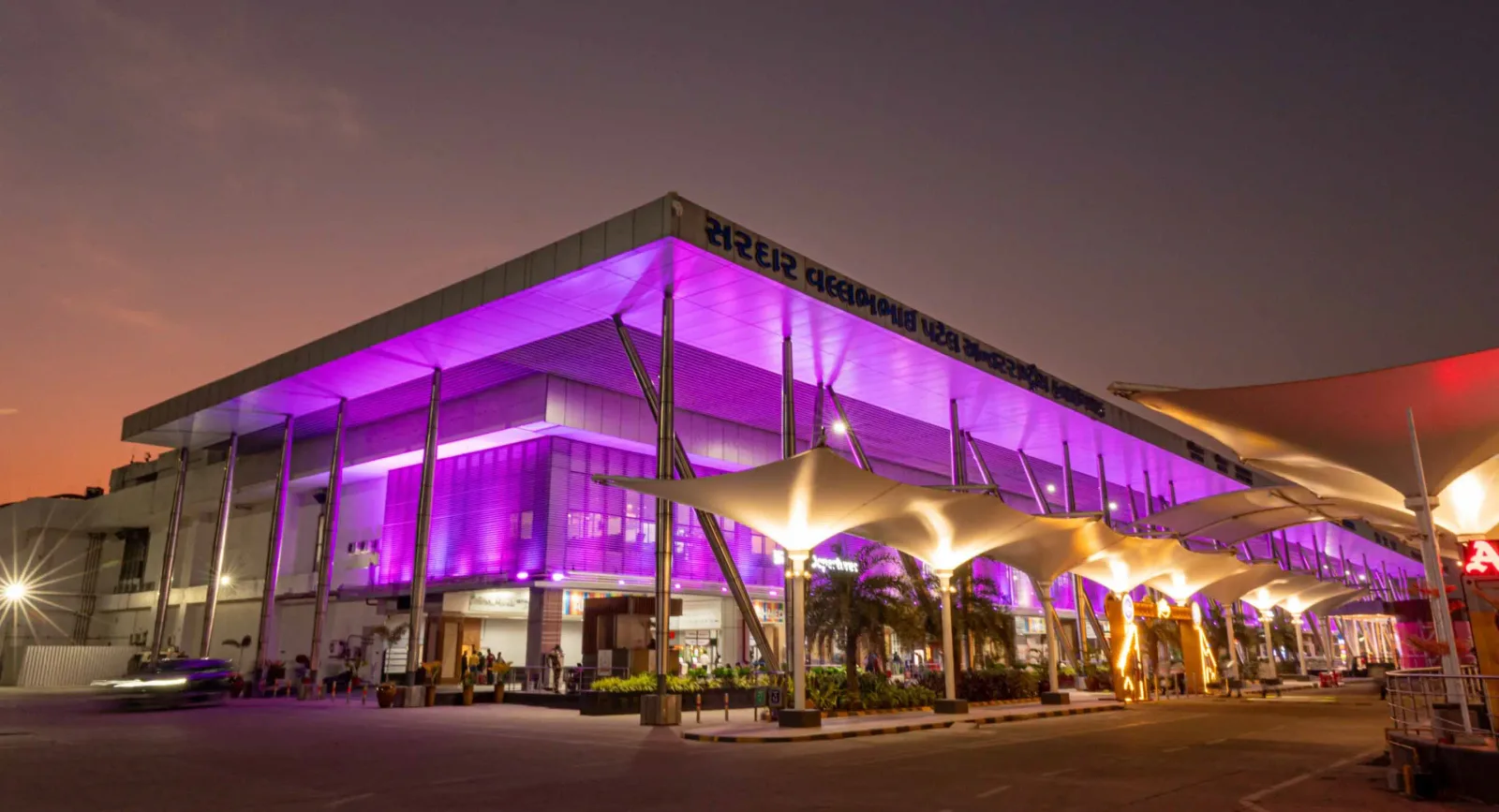
The terminal at night — purple light washing the cantilevered roof, columns over the kerbside, and the airport name in Gujarati along the fascia.
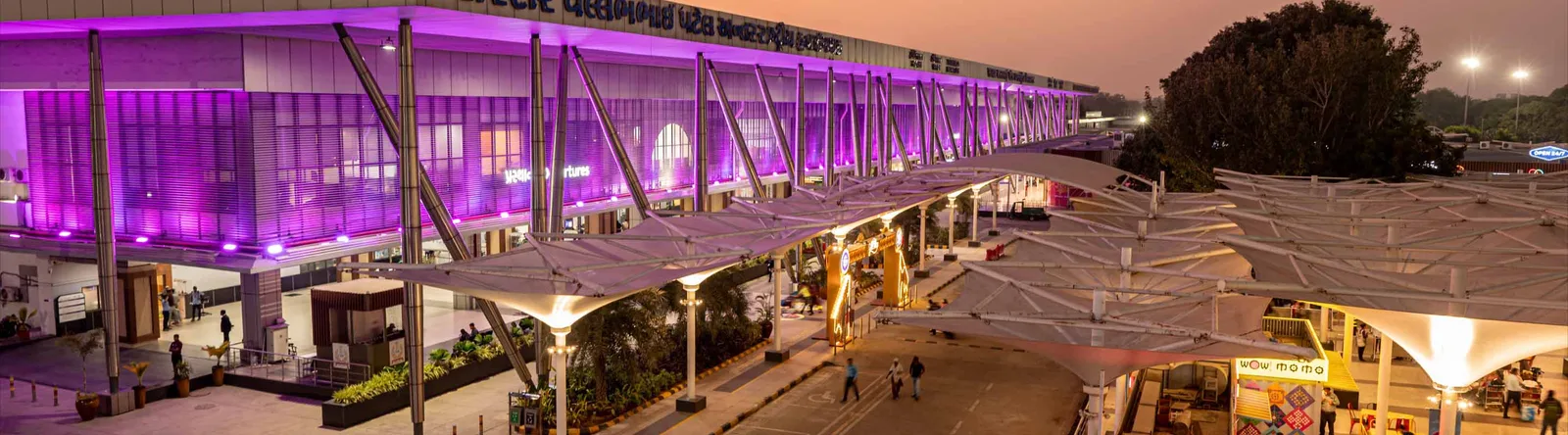
The terminal from the drop-off area — white tensile canopies over the roadway, with a continuous glass-and-steel frontage.

An art wall inside the terminal — two bronze figures in front of a line-drawn cityscape, with a screen showing the airport full name.
The photos come from the airport's official Adani Airports site and remain the copyright of their photographers; full credits and source links sit in the photo gallery on this page.
Airport at a glance
| Item | Detail |
|---|---|
| IATA / ICAO | AMD / VAAH |
| Role | Large airport and international gateway for Gujarat |
| Elevation | about 58 m |
| Coordinates | 23.0772, 72.6347 |
| Runway | 1: 05/23, 3,505 m × 46 m asphalt |
| Non-stop destinations | 18 (9 domestic, 9 international; 2014 snapshot) |
| Official site | svpia-ahmedabad.adaniairports.com |
Network shape: nine domestic, nine international
By distance: 6 destinations within 1,000 km, 10 between 1,000 and 3,000 km, 2 between 3,000 and 6,000 km, and none beyond 6,000 km. The near layer is Mumbai (444 km), Pune (517 km) and Jaipur (526 km). The far layer is Kuwait (2,549 km), Kuala Lumpur (3,861 km) and Singapore (4,157 km). Nine domestic routes tie Ahmedabad to India's main cities; nine international ones point to the Gulf, Southeast Asia and South Asian neighbours.
| Distance band | Destinations |
|---|---|
| Under 1,000 km | 6 |
| 1,000–3,000 km | 10 |
| 3,000–6,000 km | 2 |
| Over 6,000 km | 0 |
IndiGo Airlines appears on 9 routes, SpiceJet on 7, Air India on 4, and Jet Airways and Go Air on 3 each. The carrier column includes codeshares, so the figures describe concentration. The full list is on the Ahmedabad route map.
Getting there and navigating
- Coordinates: 23.0772, 72.6347
- Official site: svpia-ahmedabad.adaniairports.com
- Open in a map: Google Maps | Amap | Baidu Maps
If fares are close, compare Delhi (DEL): about 755 km away with 96 non-stop destinations. Delhi is also on AMD's own route map, so a short connection is practical; for Europe or North America, the usual path is via Delhi, Mumbai or a Gulf hub.
The location map on this page shows the field against Ahmedabad and the road network. This page does not cover terminal connections or local transport; confirm them with the airport or airline.
Before you fly
- Allow 2–3 hours for an international departure and 90–120 minutes for a domestic one. A single-runway airport can queue at morning and evening peaks.
- The 18 destinations are a 2014 snapshot. IndiGo and SpiceJet have expanded their Indian networks substantially since; check the airline's current schedule.
- The purple lighting and tensile canopies are part of the terminal's exterior. At night the kerbside is darker than the building, so agree on a pickup point with your driver in advance.
About the data
Runways, elevation and coordinates come from OurAirports open data. Routes and carriers come from the June 2014 OpenFlights snapshot and include codeshares and interline services; they indicate network shape and scale, not current schedules. Photos come from the airport's official Adani Airports site and remain the copyright of their photographers.
History
Named after India's first deputy prime minister, Sardar Vallabhbhai Patel, the airport serves Ahmedabad and Gandhinagar as the country's eighth busiest field — some 250 movements a day. It spans 1,124 acres with a 3,600 m runway and four terminals (domestic, international, secondary and cargo).
Source: Ahmedabad Airport.
Bình luận của độc giảThảo luận
Hoan nghênh mọi câu hỏi, báo cáo chuyến đi và góp ý chỉnh sửa. Bình luận được công khai.
Đang tải…
Đang tải bình luận…