
Sardar Vallabh Patel International Airport
 อะห์มดาบาด · อินเดีย· Sardar Vallabh Patel International Airport
Sardar Vallabh Patel International Airport (IATA: AMD, ICAO VAAH) เป็นสนามบินขนาดใหญ่ที่ให้บริการอะห์มดาบาด, อินเดีย
Sardar Vallabh Patel International Airport is a large airport, at an elevation of about 189 ft, with scheduled passenger service. This page gathers its location map, airport codes and travel information.
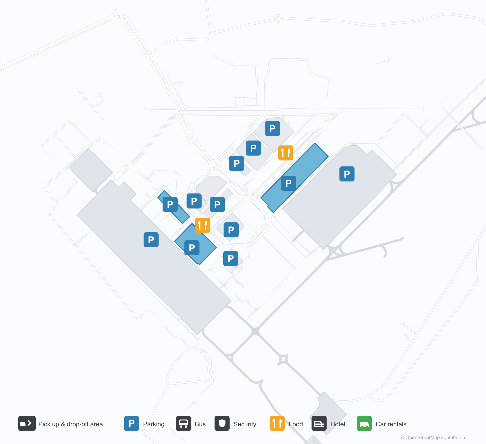
ดาวน์โหลดแผนที่สนามบินดาวน์โหลด
ภาพสนามบินภาพสนามบิน
ภาพจริงของสนามบินแห่งนี้ พร้อมเครดิตของหน้าเว็บสาธารณะที่พบภาพ; ลิขสิทธิ์ยังเป็นของผู้ถ่ายภาพต้นฉบับ คลิกที่ภาพเพื่อขยาย หรือคลิกบรรทัดเครดิตเพื่อเปิดหน้าแหล่งที่มา
อาคารผู้โดยสารยามค่ำคืน — แสงสีม่วงอาบหลังคาที่ยื่นลอย เสาเหนือขอบถนน และชื่อสนามบินภาษาคุชราตตามแนวชายคา
อาคารผู้โดยสารมองจากพื้นที่จอดส่ง — หลังคาแรงดึงสีขาวเหนือถนน พร้อมด้านหน้ากระจกและเหล็กต่อเนื่อง
ผนังศิลปะภายในอาคารผู้โดยสาร — รูปปั้นทองสัมฤทธิ์สองตัวหน้าภาพวาดเส้นของเมือง พร้อมจอแสดงชื่อเต็มของสนามบิน
ในยามกลางวัน ด้านหน้าอาคารผู้โดยสารมีชื่อเต็มของสนามบินเป็นตัวอักษรสีน้ำเงิน โดยมีผู้เดินทางและรถยนต์สีขาวเคลื่อนไปตามขอบถนนด้านล่าง
เมื่อพลบค่ำลึกขึ้น แสงสีม่วงอาบด้านหน้าอาคารผู้โดยสาร ขณะที่ทางเดินหลังคากันแดดสีขาวทอดข้ามถนนไปยังแถวร้านค้าเล็ก ๆ ที่สว่างไสว
เครื่องบินโดยสารลาย IndiGo จอดอยู่บนลานคอนกรีต โดยมีอาคารผู้โดยสารและเครื่องหมายทางขับที่ทาสีอยู่ด้านหลัง
ภาพถ่ายทางอากาศของอาคารผู้โดยสารแสดงหลังคาสีเงินหลายส่วน ลานจอดรถและถนนวงแหวนด้านหน้า โดยมีเครื่องบินโดยสารหนึ่งลำจอดอยู่บนลานจอดข้าง ๆ
ยามค่ำคืน หลังคาแรงดึงสีขาวที่ส่องสว่างจากด้านล่างให้ร่มเงาแก่ผู้เดินเล่นบนลานหน้า โดยมีด้านหน้าอาคารผู้โดยสารที่สว่างไสวอยู่ด้านหลัง
ภาพถ่ายทางอากาศยามพลบค่ำของหอสูงที่ผายออกด้านบน เรืองแสงโทนอุ่นพร้อมแถบแสงสี อยู่ข้างอาคารเตี้ยกว่าและเมืองที่สว่างไสวใต้เนินเขา
บนลานจอดที่เปียกฝนยามค่ำคืน เครื่องบินเจ็ตของ IndiGo รออยู่ที่ช่องจอด ขณะที่อุปกรณ์ภาคพื้นตั้งอยู่ใกล้จมูกเครื่อง
แผนที่เส้นทาง Sardar Vallabh Patel International Airport — จุดหมายบินตรงแผนที่เส้นทาง
18 จุดหมายบินตรง: แผนที่ สายการบินที่ให้บริการ และระยะทาง
เที่ยวบินของSardar Vallabh Patel International Airport — ขาออกและขาเข้าป้ายเที่ยวบิน
847 หมายเลขเที่ยวบิน ครอบคลุม 45 สายการบิน และ 55 จุดหมายปลายทาง แยกตามทิศทาง หมายเลขเที่ยวบินร่วม (codeshare) รวมอยู่ด้วย
| เที่ยวบิน | สายการบิน | จุดหมายปลายทาง | ประเทศ/ภูมิภาค |
|---|---|---|---|
| 3L112 | Air Arabia Abu Dhabi | Zayed International Airport | สหรัฐอาหรับเอมิเรตส์ |
| 6E75 | IndiGo | King Abdulaziz International Airport | ซาอุดีอาระเบีย |
| 6E133 | IndiGo | Dehradun (Jauligrant) (DED) Dehradun Jolly Grant Airport | อินเดีย |
| 6E181 | IndiGo | Rajiv Gandhi International Airport | อินเดีย |
| 6E319 | IndiGo | Netaji Subhash Chandra Bose International Airport | อินเดีย |
| 6E346 | IndiGo | อัมริตซาร์ (ATQ) Sri Guru Ram Das Ji International Airport | อินเดีย |
| 6E348 | IndiGo | Chennai International Airport | อินเดีย |
| 6E367 | IndiGo | Vasco da Gama (GOI) Goa Dabolim International Airport | อินเดีย |
| 6E383 | IndiGo | Rajiv Gandhi International Airport | อินเดีย |
| 6E396 | IndiGo | ท่าอากาศยานนานาชาติอินทิรา คานธี | อินเดีย |
| 6E431 | IndiGo | Chennai International Airport | อินเดีย |
| 6E450 | IndiGo | Netaji Subhash Chandra Bose International Airport | อินเดีย |
| 6E479 | IndiGo | Chennai International Airport | อินเดีย |
| 6E481 | IndiGo | Kempegowda International Airport Bengaluru | อินเดีย |
| 6E522 | IndiGo | Navi Mumbai (NMI) Navi Mumbai International Airport | อินเดีย |
| 6E522 | IndiGo | Pune (PNQ) Pune International Airport | อินเดีย |
| 6E635 | IndiGo | Rajiv Gandhi International Airport | อินเดีย |
| 6E699 | IndiGo | Pune (PNQ) Pune International Airport | อินเดีย |
| 6E751 | IndiGo | Netaji Subhash Chandra Bose International Airport | อินเดีย |
| 6E793 | IndiGo | Chhatrapati Shivaji Maharaj International Airport | อินเดีย |
หมายเลขเที่ยวบินและเส้นทางจากดัชนีเที่ยวบิน aviability.com (ข้อมูล ณ วันที่ 26 ตุลาคม 2569); รวมหมายเลขเที่ยวบินร่วมและไม่แสดงเวลาเดินทาง ที่มา: aviability.com ↗
ข้อมูลและรายละเอียดสนามบินรายละเอียดสนามบิน
แผนที่อินเทอร์แอกทีฟ — ตำแหน่ง Sardar Vallabh Patel International Airportแผนที่อินเทอร์แอกทีฟ
ดูสนามบินนี้บนบริการแผนที่อื่น:
Ahmedabad Airport (AMD): Eighteen Routes Under a Purple Roofคู่มือสนามบิน
The official photos of Ahmedabad's airport lead with colour: the terminal's cantilevered roof washed in purple light, columns over the kerbside, and a second view where white tensile canopies spread above the drop-off road and a glass-and-steel frontage runs along the building. This is not an airport that relies on sheer size for identity. Inside, an art wall sets two bronze figures against a line-drawn cityscape, with a screen carrying the airport's full name.
Sardar Vallabhbhai Patel International Airport (IATA AMD, ICAO VAAH) serves Ahmedabad in Gujarat, India, at an elevation of about 58 m, with a single 3,505 m runway (05/23). The 2014 route snapshot records 18 non-stop destinations, split evenly between domestic and international.
Airport photos
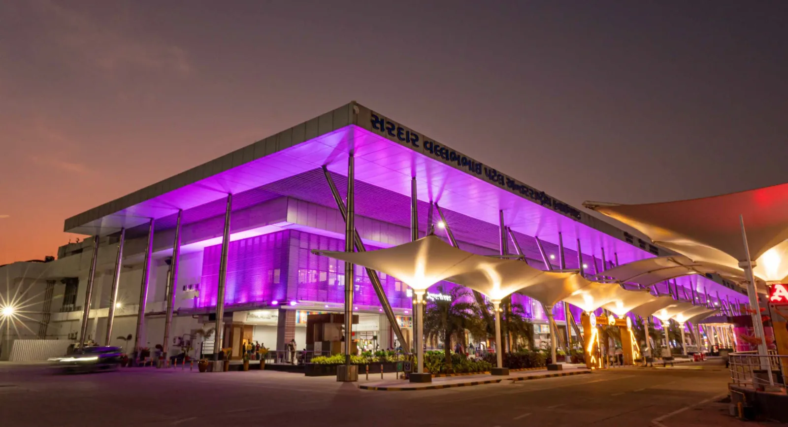
The terminal at night — purple light washing the cantilevered roof, columns over the kerbside, and the airport name in Gujarati along the fascia.
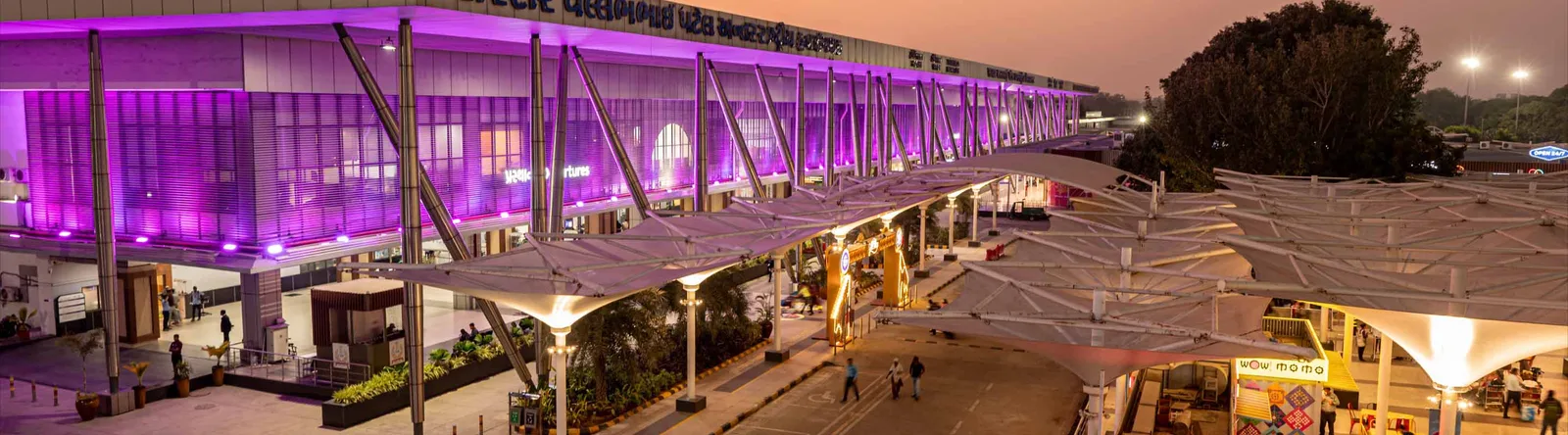
The terminal from the drop-off area — white tensile canopies over the roadway, with a continuous glass-and-steel frontage.

An art wall inside the terminal — two bronze figures in front of a line-drawn cityscape, with a screen showing the airport full name.
The photos come from the airport's official Adani Airports site and remain the copyright of their photographers; full credits and source links sit in the photo gallery on this page.
Airport at a glance
| Item | Detail |
|---|---|
| IATA / ICAO | AMD / VAAH |
| Role | Large airport and international gateway for Gujarat |
| Elevation | about 58 m |
| Coordinates | 23.0772, 72.6347 |
| Runway | 1: 05/23, 3,505 m × 46 m asphalt |
| Non-stop destinations | 18 (9 domestic, 9 international; 2014 snapshot) |
| Official site | svpia-ahmedabad.adaniairports.com |
Network shape: nine domestic, nine international
By distance: 6 destinations within 1,000 km, 10 between 1,000 and 3,000 km, 2 between 3,000 and 6,000 km, and none beyond 6,000 km. The near layer is Mumbai (444 km), Pune (517 km) and Jaipur (526 km). The far layer is Kuwait (2,549 km), Kuala Lumpur (3,861 km) and Singapore (4,157 km). Nine domestic routes tie Ahmedabad to India's main cities; nine international ones point to the Gulf, Southeast Asia and South Asian neighbours.
| Distance band | Destinations |
|---|---|
| Under 1,000 km | 6 |
| 1,000–3,000 km | 10 |
| 3,000–6,000 km | 2 |
| Over 6,000 km | 0 |
IndiGo Airlines appears on 9 routes, SpiceJet on 7, Air India on 4, and Jet Airways and Go Air on 3 each. The carrier column includes codeshares, so the figures describe concentration. The full list is on the Ahmedabad route map.
Getting there and navigating
- Coordinates: 23.0772, 72.6347
- Official site: svpia-ahmedabad.adaniairports.com
- Open in a map: Google Maps | Amap | Baidu Maps
If fares are close, compare Delhi (DEL): about 755 km away with 96 non-stop destinations. Delhi is also on AMD's own route map, so a short connection is practical; for Europe or North America, the usual path is via Delhi, Mumbai or a Gulf hub.
The location map on this page shows the field against Ahmedabad and the road network. This page does not cover terminal connections or local transport; confirm them with the airport or airline.
Before you fly
- Allow 2–3 hours for an international departure and 90–120 minutes for a domestic one. A single-runway airport can queue at morning and evening peaks.
- The 18 destinations are a 2014 snapshot. IndiGo and SpiceJet have expanded their Indian networks substantially since; check the airline's current schedule.
- The purple lighting and tensile canopies are part of the terminal's exterior. At night the kerbside is darker than the building, so agree on a pickup point with your driver in advance.
About the data
Runways, elevation and coordinates come from OurAirports open data. Routes and carriers come from the June 2014 OpenFlights snapshot and include codeshares and interline services; they indicate network shape and scale, not current schedules. Photos come from the airport's official Adani Airports site and remain the copyright of their photographers.
History
Named after India's first deputy prime minister, Sardar Vallabhbhai Patel, the airport serves Ahmedabad and Gandhinagar as the country's eighth busiest field — some 250 movements a day. It spans 1,124 acres with a 3,600 m runway and four terminals (domestic, international, secondary and cargo).
Source: Ahmedabad Airport.
ความคิดเห็นจากผู้อ่านการสนทนา
ยินดีรับคำถาม รายงานการเดินทาง และการแก้ไข ความคิดเห็นเป็นสาธารณะ
กำลังโหลด…
กำลังโหลดความคิดเห็น…