
Sardar Vallabh Patel International Airport
 Ahmedabad · India· Sardar Vallabh Patel International Airport
Sardar Vallabh Patel International Airport (IATA: AMD, ICAO VAAH) adalah bandara besar yang melayani Ahmedabad, India.
Sardar Vallabh Patel International Airport is a large airport, at an elevation of about 189 ft, with scheduled passenger service. This page gathers its location map, airport codes and travel information.
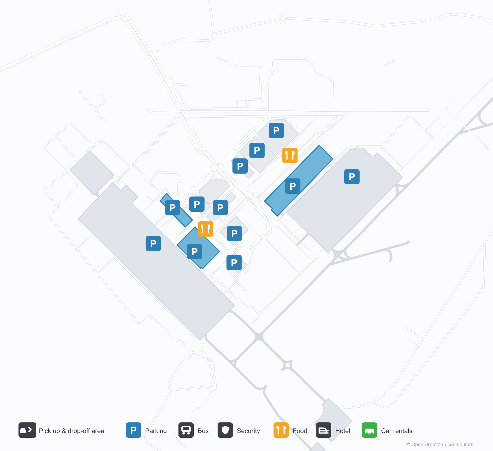
Unduh Peta BandaraUnduhan
Foto bandaraFoto Bandara
Foto asli bandara ini, masing-masing dikreditkan ke halaman web publik tempat foto ditemukan; hak cipta tetap milik fotografer aslinya. Klik foto untuk memperbesar, atau baris kredit untuk membuka halaman sumbernya.
Terminal pada malam hari — cahaya ungu menyapu atap kantilever, kolom di atas tepi jalan, dan nama bandara dalam bahasa Gujarati di sepanjang fascia.
Terminal dari area penurunan penumpang — kanopi tarik putih di atas jalan, dengan fasad kaca dan baja yang bersambung.
Dinding seni di dalam terminal — dua patung perunggu di depan lukisan garis kota, dengan layar yang menampilkan nama lengkap bandara.
Pada siang hari, fasad terminal memuat nama lengkap bandara dengan huruf biru, dengan pelancong dan mobil putih bergerak di sepanjang tepi jalan di bawahnya.
Saat senja semakin larut, cahaya ungu menyapu fasad terminal sementara jalur pejalan kaki kanopi putih membentang di atas jalan menuju deretan toko kecil yang terang.
Pesawat penumpang berlambang IndiGo berdiri di apron beton, dengan terminal dan marka taxiway tercat terlihat di latar belakang.
Pemandangan udara terminal memperlihatkan atap perak berbagian banyak, parkiran, dan jalan lingkar di depannya, dengan satu pesawat penumpang terparkir di apron di sampingnya.
Pada malam hari, kanopi tarik putih yang diterangi dari bawah menaungi pejalan kaki di plaza halaman, dengan fasad terminal yang terang di belakangnya.
Pemandangan udara senja atas menara tinggi yang melebar di puncaknya, bersinar hangat dengan pita cahaya berwarna, di samping bangunan rendah dan kota yang terang di bawah perbukitan.
Di apron licin hujan pada malam hari, pesawat jet IndiGo menunggu di standnya sementara peralatan darat berada di dekat hidung pesawat.
Peta rute Sardar Vallabh Patel International Airport — tujuan langsungPeta Rute
18 tujuan langsung: peta, maskapai yang beroperasi, dan jarak.
Penerbangan Sardar Vallabh Patel International Airport — keberangkatan & kedatanganPapan Penerbangan
847 nomor penerbangan dari 45 maskapai dan 55 tujuan, dipisahkan menurut arah. Nomor codeshare disertakan.
| Penerbangan | Maskapai | Tujuan | Negara/wilayah |
|---|---|---|---|
| 3L112 | Air Arabia Abu Dhabi | Zayed International Airport | Uni Emirat Arab |
| 6E75 | IndiGo | King Abdulaziz International Airport | Arab Saudi |
| 6E133 | IndiGo | Dehradun (Jauligrant) (DED) Dehradun Jolly Grant Airport | India |
| 6E181 | IndiGo | Rajiv Gandhi International Airport | India |
| 6E319 | IndiGo | Netaji Subhash Chandra Bose International Airport | India |
| 6E346 | IndiGo | Amritsar (ATQ) Sri Guru Ram Das Ji International Airport | India |
| 6E348 | IndiGo | Chennai International Airport | India |
| 6E367 | IndiGo | Vasco da Gama (GOI) Goa Dabolim International Airport | India |
| 6E383 | IndiGo | Rajiv Gandhi International Airport | India |
| 6E396 | IndiGo | Bandara Internasional Indira Gandhi | India |
| 6E431 | IndiGo | Chennai International Airport | India |
| 6E450 | IndiGo | Netaji Subhash Chandra Bose International Airport | India |
| 6E479 | IndiGo | Chennai International Airport | India |
| 6E481 | IndiGo | Kempegowda International Airport Bengaluru | India |
| 6E522 | IndiGo | Navi Mumbai (NMI) Navi Mumbai International Airport | India |
| 6E522 | IndiGo | Pune (PNQ) Pune International Airport | India |
| 6E635 | IndiGo | Rajiv Gandhi International Airport | India |
| 6E699 | IndiGo | Pune (PNQ) Pune International Airport | India |
| 6E751 | IndiGo | Netaji Subhash Chandra Bose International Airport | India |
| 6E793 | IndiGo | Chhatrapati Shivaji Maharaj International Airport | India |
Nomor penerbangan dan rute dari indeks penerbangan aviability.com (cuplikan 26 Oktober 2026); nomor codeshare disertakan dan waktu keberangkatan tidak ditampilkan. Sumber: aviability.com ↗
Informasi & detail bandaraDetail Bandara
Peta interaktif — lokasi Sardar Vallabh Patel International AirportPeta Interaktif
Lihat bandara ini di layanan peta lain:
Ahmedabad Airport (AMD): Eighteen Routes Under a Purple RoofPanduan Bandara
The official photos of Ahmedabad's airport lead with colour: the terminal's cantilevered roof washed in purple light, columns over the kerbside, and a second view where white tensile canopies spread above the drop-off road and a glass-and-steel frontage runs along the building. This is not an airport that relies on sheer size for identity. Inside, an art wall sets two bronze figures against a line-drawn cityscape, with a screen carrying the airport's full name.
Sardar Vallabhbhai Patel International Airport (IATA AMD, ICAO VAAH) serves Ahmedabad in Gujarat, India, at an elevation of about 58 m, with a single 3,505 m runway (05/23). The 2014 route snapshot records 18 non-stop destinations, split evenly between domestic and international.
Airport photos
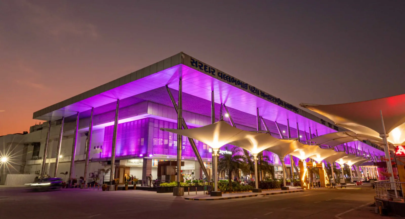
The terminal at night — purple light washing the cantilevered roof, columns over the kerbside, and the airport name in Gujarati along the fascia.
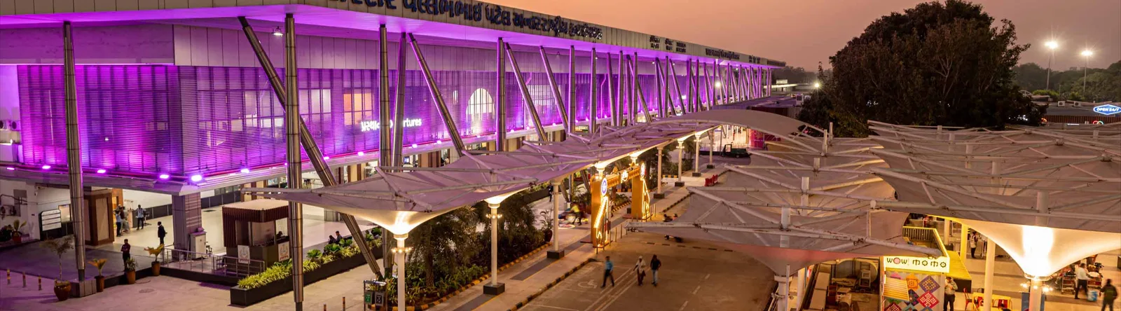
The terminal from the drop-off area — white tensile canopies over the roadway, with a continuous glass-and-steel frontage.

An art wall inside the terminal — two bronze figures in front of a line-drawn cityscape, with a screen showing the airport full name.
The photos come from the airport's official Adani Airports site and remain the copyright of their photographers; full credits and source links sit in the photo gallery on this page.
Airport at a glance
| Item | Detail |
|---|---|
| IATA / ICAO | AMD / VAAH |
| Role | Large airport and international gateway for Gujarat |
| Elevation | about 58 m |
| Coordinates | 23.0772, 72.6347 |
| Runway | 1: 05/23, 3,505 m × 46 m asphalt |
| Non-stop destinations | 18 (9 domestic, 9 international; 2014 snapshot) |
| Official site | svpia-ahmedabad.adaniairports.com |
Network shape: nine domestic, nine international
By distance: 6 destinations within 1,000 km, 10 between 1,000 and 3,000 km, 2 between 3,000 and 6,000 km, and none beyond 6,000 km. The near layer is Mumbai (444 km), Pune (517 km) and Jaipur (526 km). The far layer is Kuwait (2,549 km), Kuala Lumpur (3,861 km) and Singapore (4,157 km). Nine domestic routes tie Ahmedabad to India's main cities; nine international ones point to the Gulf, Southeast Asia and South Asian neighbours.
| Distance band | Destinations |
|---|---|
| Under 1,000 km | 6 |
| 1,000–3,000 km | 10 |
| 3,000–6,000 km | 2 |
| Over 6,000 km | 0 |
IndiGo Airlines appears on 9 routes, SpiceJet on 7, Air India on 4, and Jet Airways and Go Air on 3 each. The carrier column includes codeshares, so the figures describe concentration. The full list is on the Ahmedabad route map.
Getting there and navigating
- Coordinates: 23.0772, 72.6347
- Official site: svpia-ahmedabad.adaniairports.com
- Open in a map: Google Maps | Amap | Baidu Maps
If fares are close, compare Delhi (DEL): about 755 km away with 96 non-stop destinations. Delhi is also on AMD's own route map, so a short connection is practical; for Europe or North America, the usual path is via Delhi, Mumbai or a Gulf hub.
The location map on this page shows the field against Ahmedabad and the road network. This page does not cover terminal connections or local transport; confirm them with the airport or airline.
Before you fly
- Allow 2–3 hours for an international departure and 90–120 minutes for a domestic one. A single-runway airport can queue at morning and evening peaks.
- The 18 destinations are a 2014 snapshot. IndiGo and SpiceJet have expanded their Indian networks substantially since; check the airline's current schedule.
- The purple lighting and tensile canopies are part of the terminal's exterior. At night the kerbside is darker than the building, so agree on a pickup point with your driver in advance.
About the data
Runways, elevation and coordinates come from OurAirports open data. Routes and carriers come from the June 2014 OpenFlights snapshot and include codeshares and interline services; they indicate network shape and scale, not current schedules. Photos come from the airport's official Adani Airports site and remain the copyright of their photographers.
History
Named after India's first deputy prime minister, Sardar Vallabhbhai Patel, the airport serves Ahmedabad and Gandhinagar as the country's eighth busiest field — some 250 movements a day. It spans 1,124 acres with a 3,600 m runway and four terminals (domestic, international, secondary and cargo).
Source: Ahmedabad Airport.
Komentar pembacaDiskusi
Pertanyaan, laporan perjalanan, dan koreksi sangat kami harapkan. Komentar bersifat publik.
Memuat…
Memuat komentar…