
Alice Springs Airport
 Alice Springs · ออสเตรเลีย· Alice Springs Airport
Alice Springs Airport (IATA: ASP, ICAO YBAS) เป็นสนามบินขนาดกลางที่ให้บริการAlice Springs, ออสเตรเลีย
Alice Springs Airport is a medium-sized airport, at an elevation of about 1,789 ft, with scheduled passenger service. This page gathers its location map, airport codes and travel information.
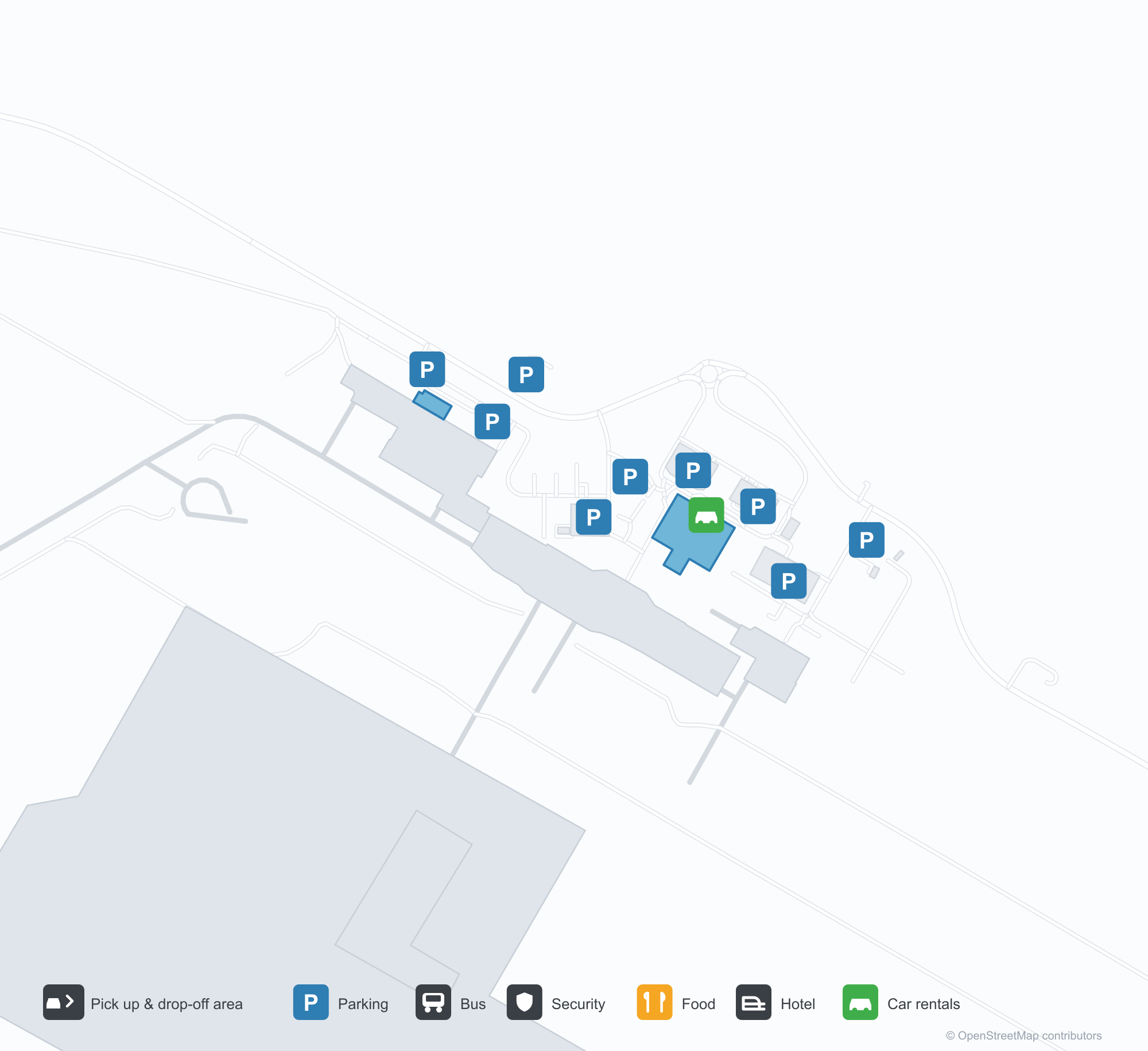
ดาวน์โหลดแผนที่สนามบินดาวน์โหลด
ภาพสนามบินภาพสนามบิน
ภาพจริงของสนามบินแห่งนี้ พร้อมเครดิตของหน้าเว็บสาธารณะที่พบภาพ; ลิขสิทธิ์ยังเป็นของผู้ถ่ายภาพต้นฉบับ คลิกที่ภาพเพื่อขยาย หรือคลิกบรรทัดเครดิตเพื่อเปิดหน้าแหล่งที่มา
หอบังคับการบินเก่าของอลิซสปริงส์ — เพลาอิฐใต้ห้องควบคุมกระจก มีเครื่องบิน Fokker F.27 รออยู่บนลานจอด (ราว ค.ศ. 1970; ภาพโดย Terry Martin คอลเลกชัน CAHS ผ่าน Airways Museum)
อลิซสปริงส์มองจากอากาศ — ทางวิ่งและทางขับปูข้ามทะเลทรายแดง หอบังคับการบิน อาคารผู้โดยสาร และลานจอดเรียงรายตามสนามบิน (คอลเลกชัน CAHS ผ่าน Airways Museum)
เสาสีแดงและกันสาดสีขาวเรียงตามขอบถนนหน้าอาคารผู้โดยสาร ป้าย Qantas บนชายคาด้านบน พร้อมรถยนต์และรถตู้สีขาวจอดอยู่ด้านนอก
ภาพถ่ายทางอากาศเผยให้เห็นทางวิ่งยาว ทางขับ และลานจอดที่มีเครื่องบินเบาหลายลำจอดอยู่ อาคารผู้โดยสาร โรงเก็บอากาศยาน และลานจอดรถกระจายอยู่บนพื้นทะเลทรายแดง
หางสีแดงของเครื่องบินโดยสาร Virgin เต็มกรอบภาพเหนือเครื่องยนต์ท้ายลำ โดยมีเจ้าหน้าที่ภาคพื้นสองคนยืนอยู่ใต้ปีกท่ามกลางดอกไม้ป่าสีเหลือง
ที่นั่งสีดำว่างเปล่าเต็มเลานจ์ขาออกอันเงียบสงบ เคาน์เตอร์ตัวแทนท่องเที่ยวข้าง ๆ ปิดอยู่หลังมู่ลี่ แผงผนังลายทางและพื้นขัดเงาภายใต้ไฟเพดาน
ภาพถ่ายทางอากาศมองลงมาที่เครื่องบินโดยสารสี่ลำจอดเคียงกันบนช่องจอดดินแดง ทางวิ่งตัดผ่านไม้พุ่มเบื้องหลัง และแนวเขาต่ำ ๆ ที่ขอบฟ้า
เครื่องบินเจ็ตภูมิภาค QantasLink ไต่ขึ้นจากทางวิ่งทะเลทราย หางสีแดงสดตัดกับท้องฟ้าใส ขณะที่เครื่องบินโดยสารสองลำที่จอดเก็บอยู่เลยสนามหญ้าแห้งออกไป
เคาน์เตอร์เช็คอิน Qantas เรียงในโถงหลังแผงกั้นคิวสีแดงที่คดเคี้ยวไปยังป้ายประกาศสุขภาพ ทั้งหมดอยู่บนพรมลายสีฟ้าและเหลือง
แผนที่เส้นทาง Alice Springs Airport — จุดหมายบินตรงแผนที่เส้นทาง
8 จุดหมายบินตรง: แผนที่ สายการบินที่ให้บริการ และระยะทาง
เที่ยวบินของAlice Springs Airport — ขาออกและขาเข้าป้ายเที่ยวบิน
63 หมายเลขเที่ยวบิน ครอบคลุม 12 สายการบิน และ 8 จุดหมายปลายทาง แยกตามทิศทาง หมายเลขเที่ยวบินร่วม (codeshare) รวมอยู่ด้วย
| เที่ยวบิน | สายการบิน | จุดหมายปลายทาง | ประเทศ/ภูมิภาค |
|---|---|---|---|
| AA7273 | American Airlines | ท่าอากาศยานซิดนีย์คิงส์ฟอร์ดสมิธ | ออสเตรเลีย |
| AS5140 | Alaska Airlines | ท่าอากาศยานซิดนีย์คิงส์ฟอร์ดสมิธ | ออสเตรเลีย |
| CX9032 | Cathay Pacific | ท่าอากาศยานซิดนีย์คิงส์ฟอร์ดสมิธ | ออสเตรเลีย |
| EK5079 | Emirates | Adelaide International Airport | ออสเตรเลีย |
| EK5373 | Emirates | ท่าอากาศยานซิดนีย์คิงส์ฟอร์ดสมิธ | ออสเตรเลีย |
| EK5722 | Emirates | Adelaide International Airport | ออสเตรเลีย |
| NZ7036 | Air New Zealand | Melbourne Airport | ออสเตรเลีย |
| NZ7098 | Air New Zealand | Brisbane International Airport | ออสเตรเลีย |
| NZ7356 | Air New Zealand | Adelaide International Airport | ออสเตรเลีย |
| NZ7460 | Air New Zealand | Adelaide International Airport | ออสเตรเลีย |
| NZ7473 | Air New Zealand | Adelaide International Airport | ออสเตรเลีย |
| NZ7791 | Air New Zealand | ท่าอากาศยานซิดนีย์คิงส์ฟอร์ดสมิธ | ออสเตรเลีย |
| QF791 | Qantas | ท่าอากาศยานซิดนีย์คิงส์ฟอร์ดสมิธ | ออสเตรเลีย |
| QF1599 | Qantas | Melbourne Airport | ออสเตรเลีย |
| QF1817 | Qantas | Adelaide International Airport | ออสเตรเลีย |
| QF1875 | Qantas | Brisbane International Airport | ออสเตรเลีย |
| QF1955 | Qantas | Adelaide International Airport | ออสเตรเลีย |
| QF1959 | Qantas | ดาร์วิน (DRW) Darwin International Airport / RAAF Darwin | ออสเตรเลีย |
| QF1961 | Qantas | ดาร์วิน (DRW) Darwin International Airport / RAAF Darwin | ออสเตรเลีย |
| QF8657 | Qantas | เคนส์ (CNS) Cairns International Airport | ออสเตรเลีย |
หมายเลขเที่ยวบินและเส้นทางจากดัชนีเที่ยวบิน aviability.com (ข้อมูล ณ วันที่ 26 ตุลาคม 2569); รวมหมายเลขเที่ยวบินร่วมและไม่แสดงเวลาเดินทาง ที่มา: aviability.com ↗
ข้อมูลและรายละเอียดสนามบินรายละเอียดสนามบิน
แผนที่อินเทอร์แอกทีฟ — ตำแหน่ง Alice Springs Airportแผนที่อินเทอร์แอกทีฟ
ดูสนามบินนี้บนบริการแผนที่อื่น:
Alice Springs Airport (ASP): From a 1970 Control Tower to a Red-Desert Runwayคู่มือสนามบิน
The photos of Alice Springs Airport (IATA ASP, ICAO YBAS) span half a century. One shows the old control tower around 1970 — a brick shaft under a glazed cab, with a Fokker F.27 turboprop waiting on the apron. The other is a current aerial: runways and taxiways laid across red desert, with the tower, terminal and apron lined up along the field. The frame has barely changed; only the aircraft have.
The airport serves Alice Springs in Australia's Northern Territory at an elevation of about 545 m. Its main runway, 12/30, is 2,438 m long, with a second 1,133 m strip (17/35). The 2014 route snapshot records 8 non-stop destinations, all within Australia.
Airport photos
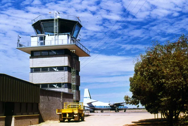
Alice Springs' old control tower — a brick shaft under the glazed cab, a Fokker F.27 waiting on the apron (c. 1970; photo Terry Martin, CAHS collection, via the Airways Museum).
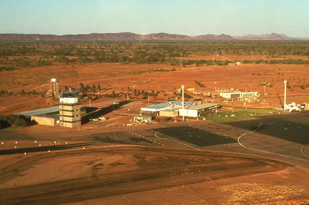
Alice Springs from the air — runways and taxiways laid across the red desert, the tower, terminal and apron lined up along the field (CAHS collection, via the Airways Museum).
The photos come from public web sources and remain the copyright of their photographers; full credits and source links sit in the photo gallery on this page.
Airport at a glance
| Item | Detail |
|---|---|
| IATA / ICAO | ASP / YBAS |
| Role | Medium-sized airport and regional gateway for central Australia |
| Elevation | about 545 m |
| Coordinates | -23.8066, 133.9034 |
| Runways | 2: 12/30 at 2,438 m, 17/35 at 1,133 m |
| Non-stop destinations | 8 (2014 snapshot, all domestic) |
| Official site | alicespringsairport.com.au |
Network shape: eight destinations, all listed for Qantas
By distance, only Ayers Rock (333 km) is within 1,000 km. The other 7 fall between 1,000 and 3,000 km, the farthest being Sydney (2,020 km), Perth (1,978 km) and Brisbane (1,965 km). This is a classic desert-spoke map: a short hop to Ayers Rock, then medium-haul links to Darwin, Adelaide, Melbourne, Perth and Sydney.
| Distance band | Destinations |
|---|---|
| Under 1,000 km | 1 |
| 1,000–3,000 km | 7 |
| Over 3,000 km | 0 |
All 8 routes list Qantas, with Tiger Airways Australia and American Airlines appearing on individual routes (including codeshares). The carrier column describes concentration, not who operates every flight. The full list is on the Alice Springs route map.
Getting there and navigating
- Coordinates: -23.8066, 133.9034
- Official site: alicespringsairport.com.au
- Open in a map: Google Maps | Amap | Baidu Maps
If your destination is not on the list, Adelaide (ADL) is the nearest larger alternative in the snapshot: about 1,317 km away with 25 destinations. Travellers heading to Ayers Rock can compare ASP and AYQ directly on distance and schedule.
The location map on this page shows the field against Alice Springs and the surrounding highway network. Terminal connections and local transport fall outside this dataset; the airport or airline can confirm them.
Before you fly
- Desert temperatures swing sharply between day and night, and summer heat is intense. The road into town is not short; a rental car or pre-booked transfer is more reliable than finding one on arrival.
- The 8 destinations are a 2014 snapshot. Qantas adjusts its central Australian schedule seasonally, so check the current timetable.
- The old tower and Fokker F.27 are historical images, not evidence of today's operators. If you plan to photograph aircraft, confirm the airport's spotting rules first.
About the data
Runways, elevation and coordinates come from OurAirports open data. Routes and carriers come from the June 2014 OpenFlights snapshot and include codeshares and interline services; they indicate network shape and scale, not current schedules. Historical photos are from the CAHS collection via the Airways Museum and remain the copyright of their photographers.
ความคิดเห็นจากผู้อ่านการสนทนา
ยินดีรับคำถาม รายงานการเดินทาง และการแก้ไข ความคิดเห็นเป็นสาธารณะ
กำลังโหลด…
กำลังโหลดความคิดเห็น…