
Alice Springs Airport
 Alice Springs · Australia· Alice Springs Airport
Alice Springs Airport (IATA: ASP, ICAO YBAS) adalah bandara sedang yang melayani Alice Springs, Australia.
Alice Springs Airport is a medium-sized airport, at an elevation of about 1,789 ft, with scheduled passenger service. This page gathers its location map, airport codes and travel information.
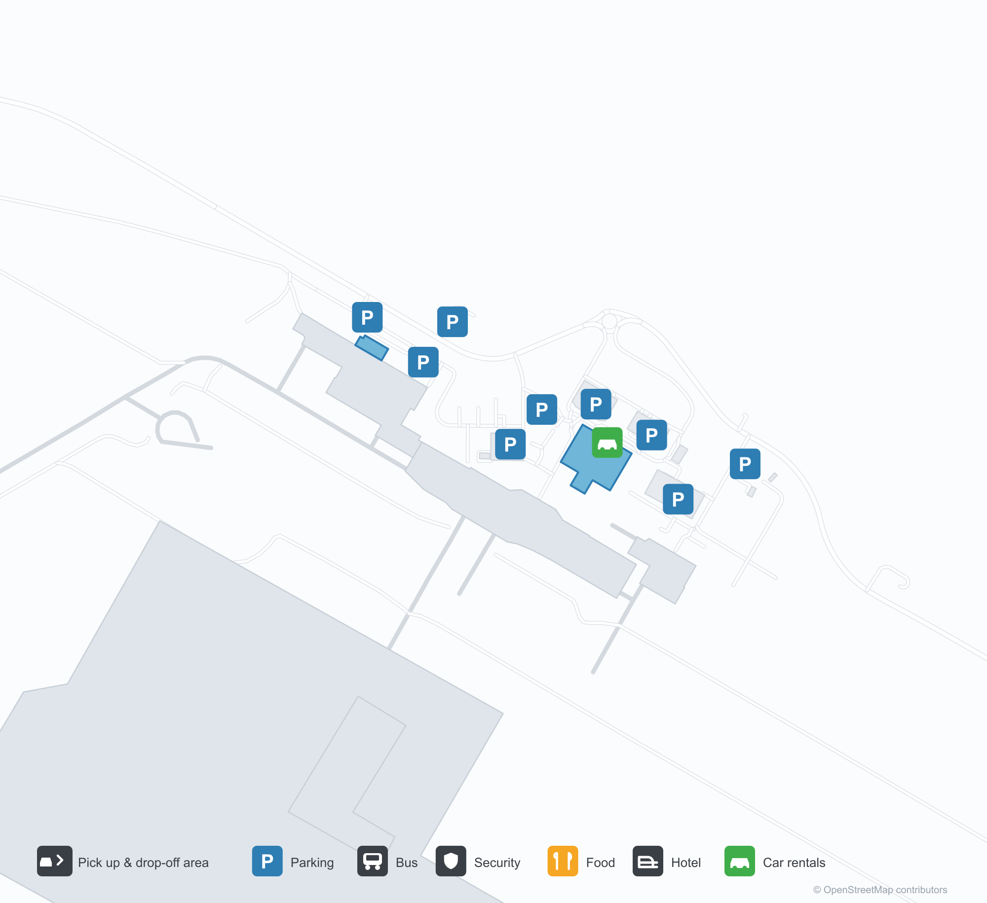
Unduh Peta BandaraUnduhan
Foto bandaraFoto Bandara
Foto asli bandara ini, masing-masing dikreditkan ke halaman web publik tempat foto ditemukan; hak cipta tetap milik fotografer aslinya. Klik foto untuk memperbesar, atau baris kredit untuk membuka halaman sumbernya.
Menara kontrol lama Alice Springs — poros bata di bawah kabin kaca, pesawat Fokker F.27 menunggu di apron (sekitar 1970; foto Terry Martin, koleksi CAHS, via Airways Museum).
Alice Springs dari udara — landasan pacu dan taxiway terbentang di gurun merah, menara, terminal, dan apron berjajar di sepanjang lapangan (koleksi CAHS, via Airways Museum).
Kolom merah dan layar peneduh putih berjajar di tepi jalan terminal, papan Qantas di fascia di atasnya, dengan mobil dan van putih menunggu di luar.
Pemandangan udara memperlihatkan landasan pacu panjang, taxiway, dan apron dengan beberapa pesawat ringan terparkir, terminal, hanggar, dan parkiran tersebar di tanah gurun merah.
Ekor merah pesawat penumpang Virgin memenuhi bingkai di atas mesin yang terpasang di belakang, dua petugas darat berdiri di bawah sayap di antara bunga liar kuning.
Kursi hitam kosong memenuhi lounge keberangkatan yang sepi, konter biro perjalanan di sampingnya tertutup jeruji, panel dinding bergaris dan lantai mengkilap di bawah lampu langit-langit.
Pemandangan udara memandang ke bawah empat pesawat penumpang terparkir berdampingan di stand tanah merah, landasan pacu melintasi semak belukar di kejauhan dan pegunungan rendah di cakrawala.
Pesawat jet regional QantasLink menanjak meninggalkan landasan pacu gurun, ekor merahnya cerah di langit cerah, sementara dua pesawat penumpang yang disimpan terparkir di seberang lintasan di balik rumput kering.
Meja check-in Qantas berjajar di aula di balik pembatas antrean merah yang berkelok menuju papan pengumuman kesehatan, semuanya di atas karpet bermotif biru dan kuning.
Peta rute Alice Springs Airport — tujuan langsungPeta Rute
8 tujuan langsung: peta, maskapai yang beroperasi, dan jarak.
Penerbangan Alice Springs Airport — keberangkatan & kedatanganPapan Penerbangan
63 nomor penerbangan dari 12 maskapai dan 8 tujuan, dipisahkan menurut arah. Nomor codeshare disertakan.
| Penerbangan | Maskapai | Tujuan | Negara/wilayah |
|---|---|---|---|
| AA7273 | American Airlines | Bandara Sydney Kingsford Smith | Australia |
| AS5140 | Alaska Airlines | Bandara Sydney Kingsford Smith | Australia |
| CX9032 | Cathay Pacific | Bandara Sydney Kingsford Smith | Australia |
| EK5079 | Emirates | Adelaide International Airport | Australia |
| EK5373 | Emirates | Bandara Sydney Kingsford Smith | Australia |
| EK5722 | Emirates | Adelaide International Airport | Australia |
| NZ7036 | Air New Zealand | Melbourne Airport | Australia |
| NZ7098 | Air New Zealand | Brisbane International Airport | Australia |
| NZ7356 | Air New Zealand | Adelaide International Airport | Australia |
| NZ7460 | Air New Zealand | Adelaide International Airport | Australia |
| NZ7473 | Air New Zealand | Adelaide International Airport | Australia |
| NZ7791 | Air New Zealand | Bandara Sydney Kingsford Smith | Australia |
| QF791 | Qantas | Bandara Sydney Kingsford Smith | Australia |
| QF1599 | Qantas | Melbourne Airport | Australia |
| QF1817 | Qantas | Adelaide International Airport | Australia |
| QF1875 | Qantas | Brisbane International Airport | Australia |
| QF1955 | Qantas | Adelaide International Airport | Australia |
| QF1959 | Qantas | Darwin (DRW) Darwin International Airport / RAAF Darwin | Australia |
| QF1961 | Qantas | Darwin (DRW) Darwin International Airport / RAAF Darwin | Australia |
| QF8657 | Qantas | Cairns (CNS) Cairns International Airport | Australia |
Nomor penerbangan dan rute dari indeks penerbangan aviability.com (cuplikan 26 Oktober 2026); nomor codeshare disertakan dan waktu keberangkatan tidak ditampilkan. Sumber: aviability.com ↗
Informasi & detail bandaraDetail Bandara
Peta interaktif — lokasi Alice Springs AirportPeta Interaktif
Lihat bandara ini di layanan peta lain:
Alice Springs Airport (ASP): From a 1970 Control Tower to a Red-Desert RunwayPanduan Bandara
The photos of Alice Springs Airport (IATA ASP, ICAO YBAS) span half a century. One shows the old control tower around 1970 — a brick shaft under a glazed cab, with a Fokker F.27 turboprop waiting on the apron. The other is a current aerial: runways and taxiways laid across red desert, with the tower, terminal and apron lined up along the field. The frame has barely changed; only the aircraft have.
The airport serves Alice Springs in Australia's Northern Territory at an elevation of about 545 m. Its main runway, 12/30, is 2,438 m long, with a second 1,133 m strip (17/35). The 2014 route snapshot records 8 non-stop destinations, all within Australia.
Airport photos
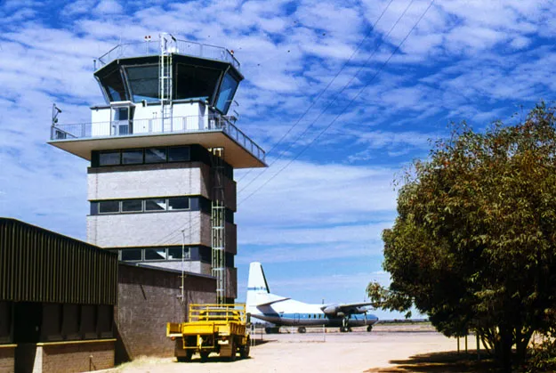
Alice Springs' old control tower — a brick shaft under the glazed cab, a Fokker F.27 waiting on the apron (c. 1970; photo Terry Martin, CAHS collection, via the Airways Museum).
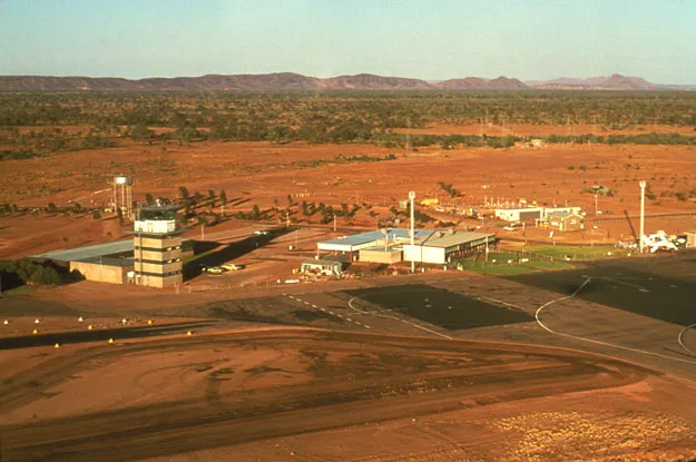
Alice Springs from the air — runways and taxiways laid across the red desert, the tower, terminal and apron lined up along the field (CAHS collection, via the Airways Museum).
The photos come from public web sources and remain the copyright of their photographers; full credits and source links sit in the photo gallery on this page.
Airport at a glance
| Item | Detail |
|---|---|
| IATA / ICAO | ASP / YBAS |
| Role | Medium-sized airport and regional gateway for central Australia |
| Elevation | about 545 m |
| Coordinates | -23.8066, 133.9034 |
| Runways | 2: 12/30 at 2,438 m, 17/35 at 1,133 m |
| Non-stop destinations | 8 (2014 snapshot, all domestic) |
| Official site | alicespringsairport.com.au |
Network shape: eight destinations, all listed for Qantas
By distance, only Ayers Rock (333 km) is within 1,000 km. The other 7 fall between 1,000 and 3,000 km, the farthest being Sydney (2,020 km), Perth (1,978 km) and Brisbane (1,965 km). This is a classic desert-spoke map: a short hop to Ayers Rock, then medium-haul links to Darwin, Adelaide, Melbourne, Perth and Sydney.
| Distance band | Destinations |
|---|---|
| Under 1,000 km | 1 |
| 1,000–3,000 km | 7 |
| Over 3,000 km | 0 |
All 8 routes list Qantas, with Tiger Airways Australia and American Airlines appearing on individual routes (including codeshares). The carrier column describes concentration, not who operates every flight. The full list is on the Alice Springs route map.
Getting there and navigating
- Coordinates: -23.8066, 133.9034
- Official site: alicespringsairport.com.au
- Open in a map: Google Maps | Amap | Baidu Maps
If your destination is not on the list, Adelaide (ADL) is the nearest larger alternative in the snapshot: about 1,317 km away with 25 destinations. Travellers heading to Ayers Rock can compare ASP and AYQ directly on distance and schedule.
The location map on this page shows the field against Alice Springs and the surrounding highway network. Terminal connections and local transport fall outside this dataset; the airport or airline can confirm them.
Before you fly
- Desert temperatures swing sharply between day and night, and summer heat is intense. The road into town is not short; a rental car or pre-booked transfer is more reliable than finding one on arrival.
- The 8 destinations are a 2014 snapshot. Qantas adjusts its central Australian schedule seasonally, so check the current timetable.
- The old tower and Fokker F.27 are historical images, not evidence of today's operators. If you plan to photograph aircraft, confirm the airport's spotting rules first.
About the data
Runways, elevation and coordinates come from OurAirports open data. Routes and carriers come from the June 2014 OpenFlights snapshot and include codeshares and interline services; they indicate network shape and scale, not current schedules. Historical photos are from the CAHS collection via the Airways Museum and remain the copyright of their photographers.
Komentar pembacaDiskusi
Pertanyaan, laporan perjalanan, dan koreksi sangat kami harapkan. Komentar bersifat publik.
Memuat…
Memuat komentar…