
Alice Springs Airport
 Alice Springs · Avustralya· Alice Springs Airport
Alice Springs Airport (IATA: ASP, ICAO YBAS), Alice Springs, Avustralya kentine hizmet veren bir orta büyüklükte havalimanıdır.
Alice Springs Airport is a medium-sized airport, at an elevation of about 1,789 ft, with scheduled passenger service. This page gathers its location map, airport codes and travel information.
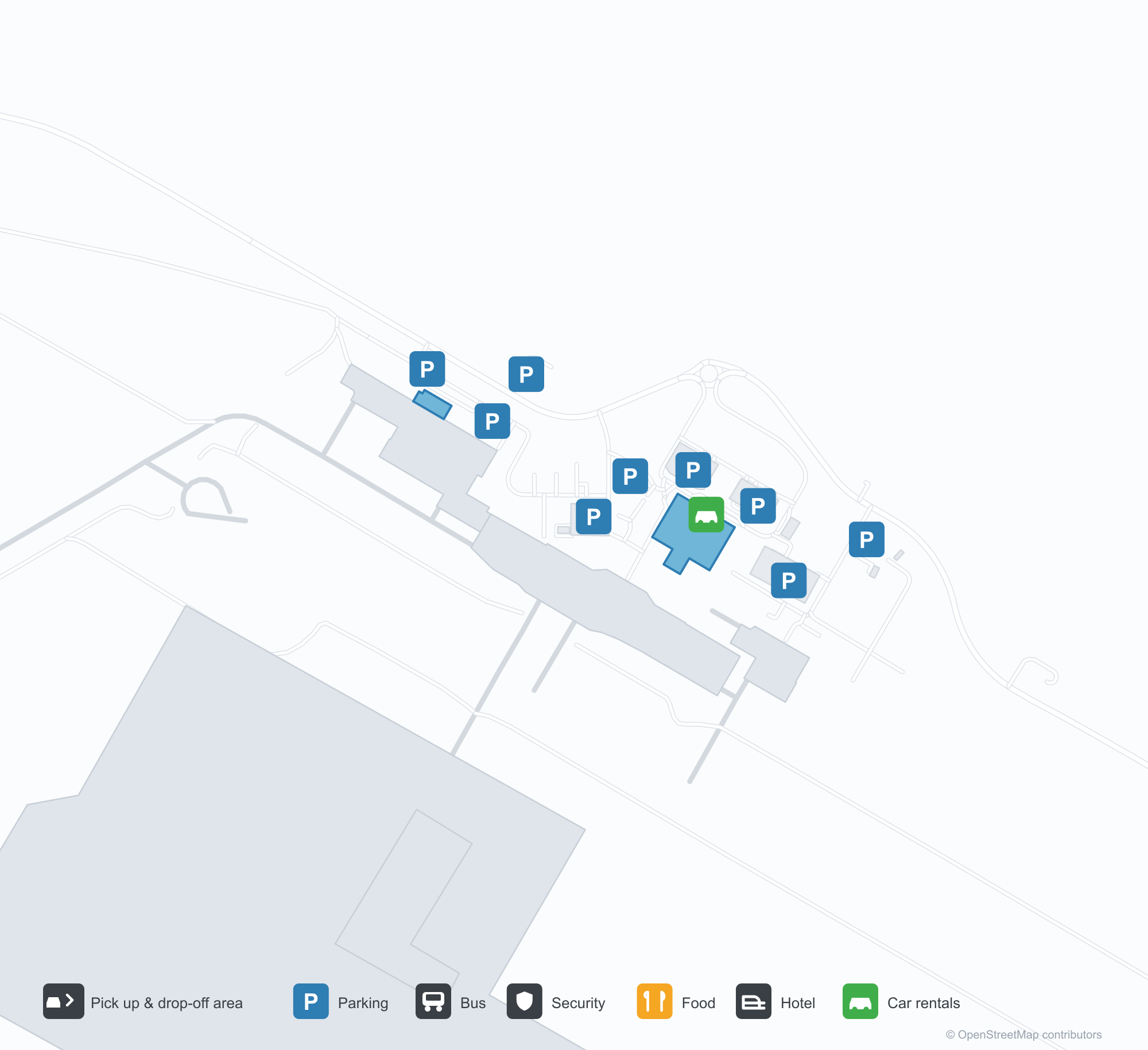
Havalimanı Haritalarını İndirinİndirmeler
Havalimanı fotoğraflarıHavalimanı Fotoğrafları
Bu havalimanının gerçek fotoğrafları; her fotoğrafın altında, fotoğrafın bulunduğu kamuya açık web sayfasına bir atıf yer alır ve telif hakkı özgün fotoğrafçılarda kalır. Yakınlaştırmak için bir fotoğrafa, kaynak sayfasını açmak için bir atıf satırına tıklayın.
Alice Springs'in eski kontrol kulesi — camlı kabinin altında tuğla bir gövde, apronda bekleyen bir Fokker F.27 (yaklaşık 1970; fotoğraf Terry Martin, CAHS koleksiyonu, Airways Museum aracılığıyla).
Havadan Alice Springs — kızıl çöl boyunca uzanan pistler ve taksi yolları; kule, terminal ve apron saha boyunca sıralanmış (CAHS koleksiyonu, Airways Museum aracılığıyla).
Kırmızı kolonlar ve beyaz gölgelik yelkenleri terminalin kaldırım kenarını süslüyor; üstteki cephede Qantas tabelası var, dışarıda arabalar ve beyaz bir minibüs bekliyor.
Havadan bir görünüm uzun pisti, taksi yolunu ve apronu seçiyor; birkaç hafif uçak park etmiş, terminal, hangarlar ve otoparklar kızıl çöl zeminine dağılmış.
Bir Virgin yolcu uçağının kırmızı kuyruğu, arka motorlarının üzerinde çerçeveyi dolduruyor; sarı kır çiçekleri arasında kanadın altında iki yer görevlisi duruyor.
Boş siyah koltuklar sessiz bir gidiş salonunu dolduruyor; yanlarındaki seyahat acentesi tezgâhı kafesiyle kapalı, duvar panelleri çizgili ve tavan ışıkları altında cilalı bir zemin var.
Havadan bir görünüm, kızıl toprak park yerlerinde yan yana park etmiş dört yolcu uçağına bakıyor; ötede çalılıkları bir pist kesiyor, ufukta alçak sıradağlar var.
Bir QantasLink bölgesel jeti çöl pistinden tırmanıyor; kırmızı kuyruğu açık gökyüzüne karşı parlak, kuru çimenlerin ötesinde iki park edilmiş yolcu uçağı pistin karşısında duruyor.
Qantas check-in bankoları salon boyunca uzanıyor; kırmızı kuyruk bariyerleri sağlık duyuru panosuna doğru kıvrılıyor, hepsi mavi-sarı desenli bir halının üzerinde.
Alice Springs Airport rota haritası — doğrudan varış noktalarıRota Haritası
8 doğrudan varış noktası: harita, sefer yapan havayolu şirketleri ve mesafeler.
Alice Springs Airport uçuşları — kalkışlar ve varışlarUçuş Panosu
63 uçuş numarası, 12 havayolu şirketi ve 8 varış noktası, yönlere göre ayrılmıştır. Ortak uçuş numaraları dahildir.
| Uçuş | Havayolu şirketi | Varış noktası | Ülke/bölge |
|---|---|---|---|
| AA7273 | American Airlines | Sidney Kingsford Smith Havalimanı | Avustralya |
| AS5140 | Alaska Airlines | Sidney Kingsford Smith Havalimanı | Avustralya |
| CX9032 | Cathay Pacific | Sidney Kingsford Smith Havalimanı | Avustralya |
| EK5079 | Emirates | Adelaide International Airport | Avustralya |
| EK5373 | Emirates | Sidney Kingsford Smith Havalimanı | Avustralya |
| EK5722 | Emirates | Adelaide International Airport | Avustralya |
| NZ7036 | Air New Zealand | Melbourne Airport | Avustralya |
| NZ7098 | Air New Zealand | Brisbane International Airport | Avustralya |
| NZ7356 | Air New Zealand | Adelaide International Airport | Avustralya |
| NZ7460 | Air New Zealand | Adelaide International Airport | Avustralya |
| NZ7473 | Air New Zealand | Adelaide International Airport | Avustralya |
| NZ7791 | Air New Zealand | Sidney Kingsford Smith Havalimanı | Avustralya |
| QF791 | Qantas | Sidney Kingsford Smith Havalimanı | Avustralya |
| QF1599 | Qantas | Melbourne Airport | Avustralya |
| QF1817 | Qantas | Adelaide International Airport | Avustralya |
| QF1875 | Qantas | Brisbane International Airport | Avustralya |
| QF1955 | Qantas | Adelaide International Airport | Avustralya |
| QF1959 | Qantas | Darwin (DRW) Darwin International Airport / RAAF Darwin | Avustralya |
| QF1961 | Qantas | Darwin (DRW) Darwin International Airport / RAAF Darwin | Avustralya |
| QF8657 | Qantas | Cairns (CNS) Cairns International Airport | Avustralya |
Uçuş numaraları ve rotalar aviability.com uçuş dizininden (anlık görüntü: 26 Ekim 2026); ortak uçuş numaraları dahildir ve kalkış saatleri gösterilmez. Kaynak: aviability.com ↗
Havalimanı bilgileri ve ayrıntılarıHavalimanı Ayrıntıları
Etkileşimli harita — Alice Springs Airport konumuEtkileşimli Harita
Bu havalimanını diğer harita hizmetlerinde görüntüleyin:
Alice Springs Airport (ASP): From a 1970 Control Tower to a Red-Desert RunwayHavalimanı Rehberi
The photos of Alice Springs Airport (IATA ASP, ICAO YBAS) span half a century. One shows the old control tower around 1970 — a brick shaft under a glazed cab, with a Fokker F.27 turboprop waiting on the apron. The other is a current aerial: runways and taxiways laid across red desert, with the tower, terminal and apron lined up along the field. The frame has barely changed; only the aircraft have.
The airport serves Alice Springs in Australia's Northern Territory at an elevation of about 545 m. Its main runway, 12/30, is 2,438 m long, with a second 1,133 m strip (17/35). The 2014 route snapshot records 8 non-stop destinations, all within Australia.
Airport photos
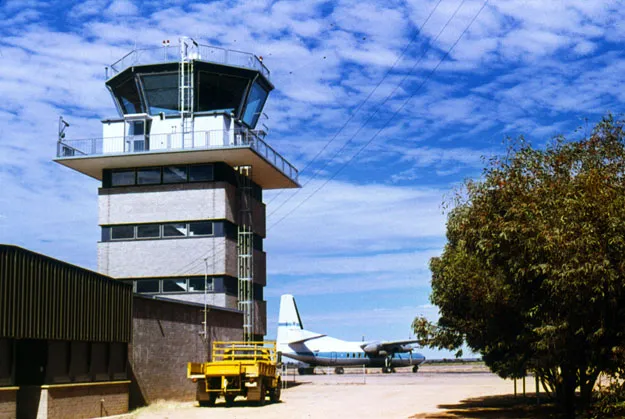
Alice Springs' old control tower — a brick shaft under the glazed cab, a Fokker F.27 waiting on the apron (c. 1970; photo Terry Martin, CAHS collection, via the Airways Museum).
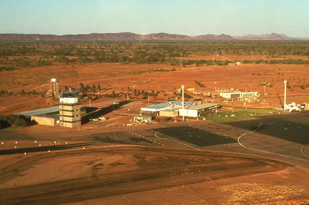
Alice Springs from the air — runways and taxiways laid across the red desert, the tower, terminal and apron lined up along the field (CAHS collection, via the Airways Museum).
The photos come from public web sources and remain the copyright of their photographers; full credits and source links sit in the photo gallery on this page.
Airport at a glance
| Item | Detail |
|---|---|
| IATA / ICAO | ASP / YBAS |
| Role | Medium-sized airport and regional gateway for central Australia |
| Elevation | about 545 m |
| Coordinates | -23.8066, 133.9034 |
| Runways | 2: 12/30 at 2,438 m, 17/35 at 1,133 m |
| Non-stop destinations | 8 (2014 snapshot, all domestic) |
| Official site | alicespringsairport.com.au |
Network shape: eight destinations, all listed for Qantas
By distance, only Ayers Rock (333 km) is within 1,000 km. The other 7 fall between 1,000 and 3,000 km, the farthest being Sydney (2,020 km), Perth (1,978 km) and Brisbane (1,965 km). This is a classic desert-spoke map: a short hop to Ayers Rock, then medium-haul links to Darwin, Adelaide, Melbourne, Perth and Sydney.
| Distance band | Destinations |
|---|---|
| Under 1,000 km | 1 |
| 1,000–3,000 km | 7 |
| Over 3,000 km | 0 |
All 8 routes list Qantas, with Tiger Airways Australia and American Airlines appearing on individual routes (including codeshares). The carrier column describes concentration, not who operates every flight. The full list is on the Alice Springs route map.
Getting there and navigating
- Coordinates: -23.8066, 133.9034
- Official site: alicespringsairport.com.au
- Open in a map: Google Maps | Amap | Baidu Maps
If your destination is not on the list, Adelaide (ADL) is the nearest larger alternative in the snapshot: about 1,317 km away with 25 destinations. Travellers heading to Ayers Rock can compare ASP and AYQ directly on distance and schedule.
The location map on this page shows the field against Alice Springs and the surrounding highway network. Terminal connections and local transport fall outside this dataset; the airport or airline can confirm them.
Before you fly
- Desert temperatures swing sharply between day and night, and summer heat is intense. The road into town is not short; a rental car or pre-booked transfer is more reliable than finding one on arrival.
- The 8 destinations are a 2014 snapshot. Qantas adjusts its central Australian schedule seasonally, so check the current timetable.
- The old tower and Fokker F.27 are historical images, not evidence of today's operators. If you plan to photograph aircraft, confirm the airport's spotting rules first.
About the data
Runways, elevation and coordinates come from OurAirports open data. Routes and carriers come from the June 2014 OpenFlights snapshot and include codeshares and interline services; they indicate network shape and scale, not current schedules. Historical photos are from the CAHS collection via the Airways Museum and remain the copyright of their photographers.
Okuyucu yorumlarıTartışma
Sorular, seyahat deneyimleri ve düzeltmeler memnuniyetle karşılanır. Yorumlar herkese açıktır.
Yükleniyor…
Yorumlar yükleniyor…