
Alice Springs Airport
 Alice Springs · Úc· Alice Springs Airport
Alice Springs Airport (IATA: ASP, ICAO YBAS) là một sân bay trung bình phục vụ Alice Springs, Úc.
Alice Springs Airport is a medium-sized airport, at an elevation of about 1,789 ft, with scheduled passenger service. This page gathers its location map, airport codes and travel information.
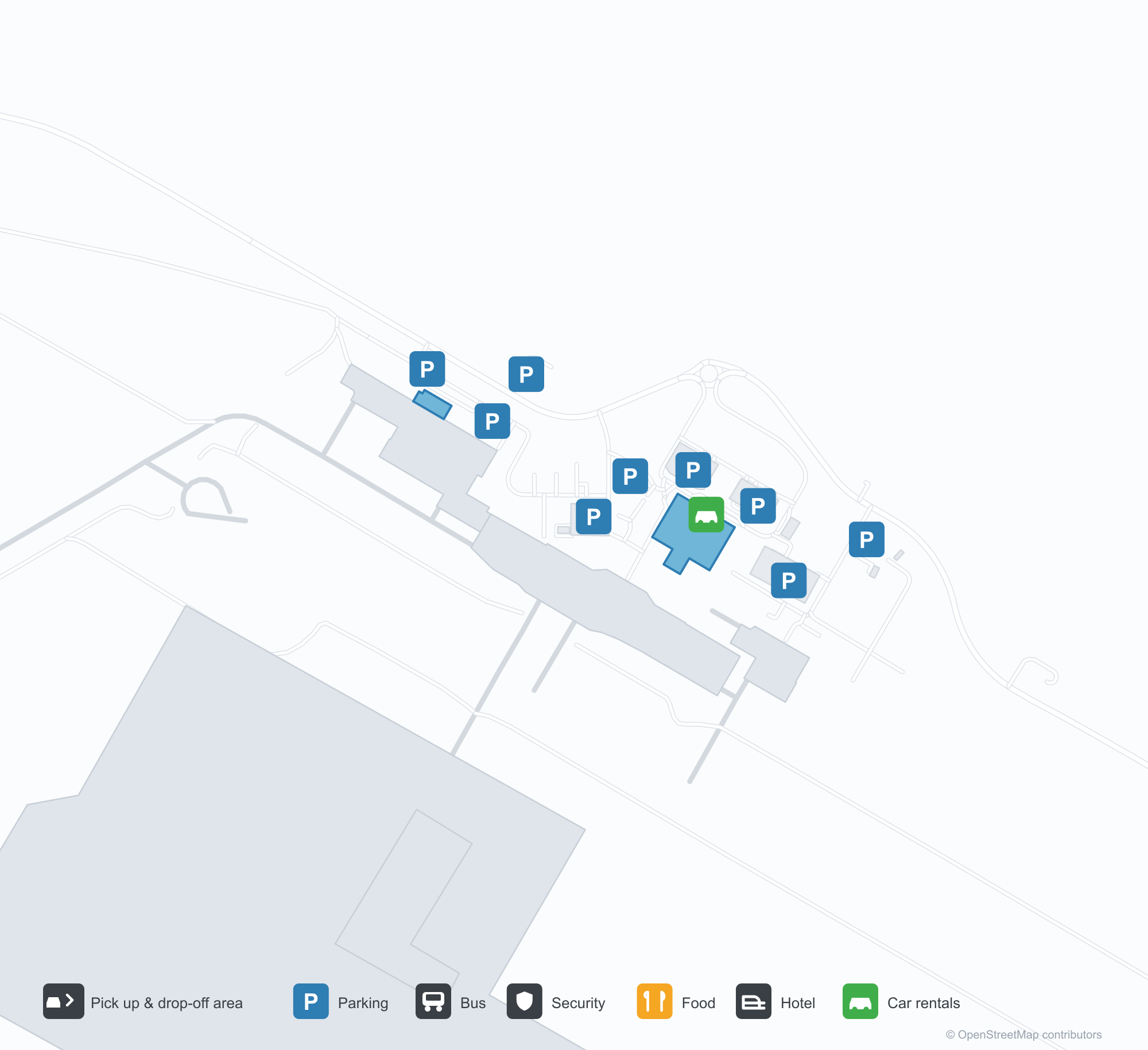
Tải bản đồ sân bayTải xuống
Ảnh sân bayẢnh sân bay
Ảnh thực tế của sân bay này, mỗi ảnh đều ghi nguồn từ trang web công khai nơi tìm thấy ảnh; bản quyền thuộc về nhiếp ảnh gia gốc. Nhấp vào ảnh để phóng to, hoặc nhấp vào dòng ghi nguồn để mở trang nguồn.
Tháp không lưu cũ của Alice Springs — thân gạch dưới cabin kính, một chiếc Fokker F.27 chờ trên sân đỗ (khoảng 1970; ảnh Terry Martin, bộ sưu tập CAHS, qua Airways Museum).
Alice Springs nhìn từ trên không — đường băng và đường lăn trải qua sa mạc đỏ, tháp không lưu, nhà ga và sân đỗ xếp dọc sân bay (bộ sưu tập CAHS, qua Airways Museum).
Những cột đỏ và bạt che nắng trắng chạy dọc lề đường trước nhà ga, biển Qantas trên dải mặt tiền phía trên, ô tô và một xe van trắng chờ bên ngoài.
Ảnh chụp từ trên cao cho thấy đường băng dài, đường lăn và sân đỗ với vài máy bay hạng nhẹ đỗ, nhà ga, nhà chứa máy bay và bãi đỗ xe rải rác trên nền sa mạc đỏ.
Đuôi đỏ của một máy bay chở khách Virgin chiếm trọn khung hình phía trên động cơ gắn sau, hai nhân viên mặt đất đứng dưới cánh giữa những bông hoa dại vàng.
Những ghế đen trống lấp đầy phòng chờ khởi hành yên tĩnh, quầy đại lý du lịch bên cạnh đóng cửa sau lưới sắt, tường ốp sọc và nền bóng dưới đèn trần.
Ảnh chụp từ trên cao nhìn xuống bốn máy bay chở khách đỗ cạnh nhau trên các vị trí đất đỏ, một đường băng cắt qua cây bụi phía xa và dãy núi thấp ở chân trời.
Một máy bay phản lực khu vực QantasLink bay lên khỏi đường băng sa mạc, đuôi đỏ nổi bật trên nền trời trong, trong khi hai máy bay chở khách lưu kho đỗ bên kia dải cỏ khô.
Các quầy làm thủ tục Qantas xếp dọc sảnh sau những rào chắn xếp hàng đỏ uốn về bảng thông báo y tế, tất cả trên thảm hoa văn xanh và vàng.
Bản đồ tuyến bay Alice Springs Airport — điểm đến thẳngBản đồ tuyến bay
8 điểm đến thẳng: bản đồ, hãng hàng không khai thác và khoảng cách.
Chuyến bay tại Alice Springs Airport — khởi hành & đếnBảng chuyến bay
63 số hiệu chuyến bay của 12 hãng hàng không, kết nối 8 điểm đến, phân theo chiều bay. Bao gồm số hiệu liên danh.
| Chuyến bay | Hãng hàng không | Điểm đến | Quốc gia/khu vực |
|---|---|---|---|
| AA7273 | American Airlines | Sân bay Kingsford Smith Sydney | Úc |
| AS5140 | Alaska Airlines | Sân bay Kingsford Smith Sydney | Úc |
| CX9032 | Cathay Pacific | Sân bay Kingsford Smith Sydney | Úc |
| EK5079 | Emirates | Adelaide International Airport | Úc |
| EK5373 | Emirates | Sân bay Kingsford Smith Sydney | Úc |
| EK5722 | Emirates | Adelaide International Airport | Úc |
| NZ7036 | Air New Zealand | Melbourne Airport | Úc |
| NZ7098 | Air New Zealand | Brisbane International Airport | Úc |
| NZ7356 | Air New Zealand | Adelaide International Airport | Úc |
| NZ7460 | Air New Zealand | Adelaide International Airport | Úc |
| NZ7473 | Air New Zealand | Adelaide International Airport | Úc |
| NZ7791 | Air New Zealand | Sân bay Kingsford Smith Sydney | Úc |
| QF791 | Qantas | Sân bay Kingsford Smith Sydney | Úc |
| QF1599 | Qantas | Melbourne Airport | Úc |
| QF1817 | Qantas | Adelaide International Airport | Úc |
| QF1875 | Qantas | Brisbane International Airport | Úc |
| QF1955 | Qantas | Adelaide International Airport | Úc |
| QF1959 | Qantas | Darwin (DRW) Darwin International Airport / RAAF Darwin | Úc |
| QF1961 | Qantas | Darwin (DRW) Darwin International Airport / RAAF Darwin | Úc |
| QF8657 | Qantas | Cairns (CNS) Cairns International Airport | Úc |
Số hiệu chuyến bay và tuyến bay từ chỉ mục chuyến bay aviability.com (ảnh chụp 26 tháng 10, 2026); bao gồm số hiệu liên danh và không hiển thị giờ khởi hành. Nguồn: aviability.com ↗
Thông tin & chi tiết sân bayChi tiết sân bay
Bản đồ tương tác — vị trí Alice Springs AirportBản đồ tương tác
Xem sân bay này trên các dịch vụ bản đồ khác:
Alice Springs Airport (ASP): From a 1970 Control Tower to a Red-Desert RunwayHướng dẫn sân bay
The photos of Alice Springs Airport (IATA ASP, ICAO YBAS) span half a century. One shows the old control tower around 1970 — a brick shaft under a glazed cab, with a Fokker F.27 turboprop waiting on the apron. The other is a current aerial: runways and taxiways laid across red desert, with the tower, terminal and apron lined up along the field. The frame has barely changed; only the aircraft have.
The airport serves Alice Springs in Australia's Northern Territory at an elevation of about 545 m. Its main runway, 12/30, is 2,438 m long, with a second 1,133 m strip (17/35). The 2014 route snapshot records 8 non-stop destinations, all within Australia.
Airport photos
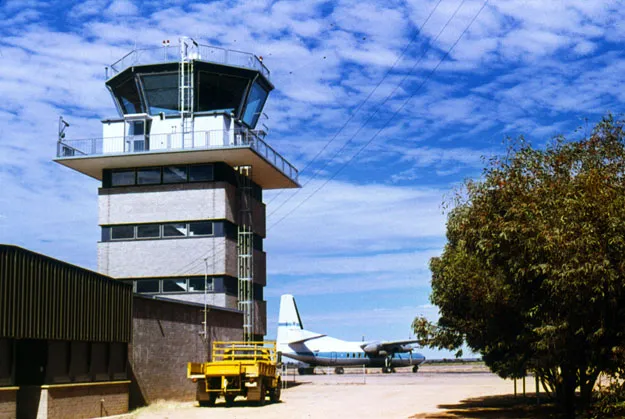
Alice Springs' old control tower — a brick shaft under the glazed cab, a Fokker F.27 waiting on the apron (c. 1970; photo Terry Martin, CAHS collection, via the Airways Museum).
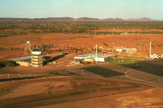
Alice Springs from the air — runways and taxiways laid across the red desert, the tower, terminal and apron lined up along the field (CAHS collection, via the Airways Museum).
The photos come from public web sources and remain the copyright of their photographers; full credits and source links sit in the photo gallery on this page.
Airport at a glance
| Item | Detail |
|---|---|
| IATA / ICAO | ASP / YBAS |
| Role | Medium-sized airport and regional gateway for central Australia |
| Elevation | about 545 m |
| Coordinates | -23.8066, 133.9034 |
| Runways | 2: 12/30 at 2,438 m, 17/35 at 1,133 m |
| Non-stop destinations | 8 (2014 snapshot, all domestic) |
| Official site | alicespringsairport.com.au |
Network shape: eight destinations, all listed for Qantas
By distance, only Ayers Rock (333 km) is within 1,000 km. The other 7 fall between 1,000 and 3,000 km, the farthest being Sydney (2,020 km), Perth (1,978 km) and Brisbane (1,965 km). This is a classic desert-spoke map: a short hop to Ayers Rock, then medium-haul links to Darwin, Adelaide, Melbourne, Perth and Sydney.
| Distance band | Destinations |
|---|---|
| Under 1,000 km | 1 |
| 1,000–3,000 km | 7 |
| Over 3,000 km | 0 |
All 8 routes list Qantas, with Tiger Airways Australia and American Airlines appearing on individual routes (including codeshares). The carrier column describes concentration, not who operates every flight. The full list is on the Alice Springs route map.
Getting there and navigating
- Coordinates: -23.8066, 133.9034
- Official site: alicespringsairport.com.au
- Open in a map: Google Maps | Amap | Baidu Maps
If your destination is not on the list, Adelaide (ADL) is the nearest larger alternative in the snapshot: about 1,317 km away with 25 destinations. Travellers heading to Ayers Rock can compare ASP and AYQ directly on distance and schedule.
The location map on this page shows the field against Alice Springs and the surrounding highway network. Terminal connections and local transport fall outside this dataset; the airport or airline can confirm them.
Before you fly
- Desert temperatures swing sharply between day and night, and summer heat is intense. The road into town is not short; a rental car or pre-booked transfer is more reliable than finding one on arrival.
- The 8 destinations are a 2014 snapshot. Qantas adjusts its central Australian schedule seasonally, so check the current timetable.
- The old tower and Fokker F.27 are historical images, not evidence of today's operators. If you plan to photograph aircraft, confirm the airport's spotting rules first.
About the data
Runways, elevation and coordinates come from OurAirports open data. Routes and carriers come from the June 2014 OpenFlights snapshot and include codeshares and interline services; they indicate network shape and scale, not current schedules. Historical photos are from the CAHS collection via the Airways Museum and remain the copyright of their photographers.
Bình luận của độc giảThảo luận
Hoan nghênh mọi câu hỏi, báo cáo chuyến đi và góp ý chỉnh sửa. Bình luận được công khai.
Đang tải…
Đang tải bình luận…