
Alice Springs Airport
 Alice Springs · オーストラリア· Alice Springs Airport
Alice Springs Airport(IATA: ASP、ICAO: YBAS)はAlice Springs、オーストラリアにある中型空港です。
Alice Springs Airport is a medium-sized airport, at an elevation of about 1,789 ft, with scheduled passenger service. This page gathers its location map, airport codes and travel information.
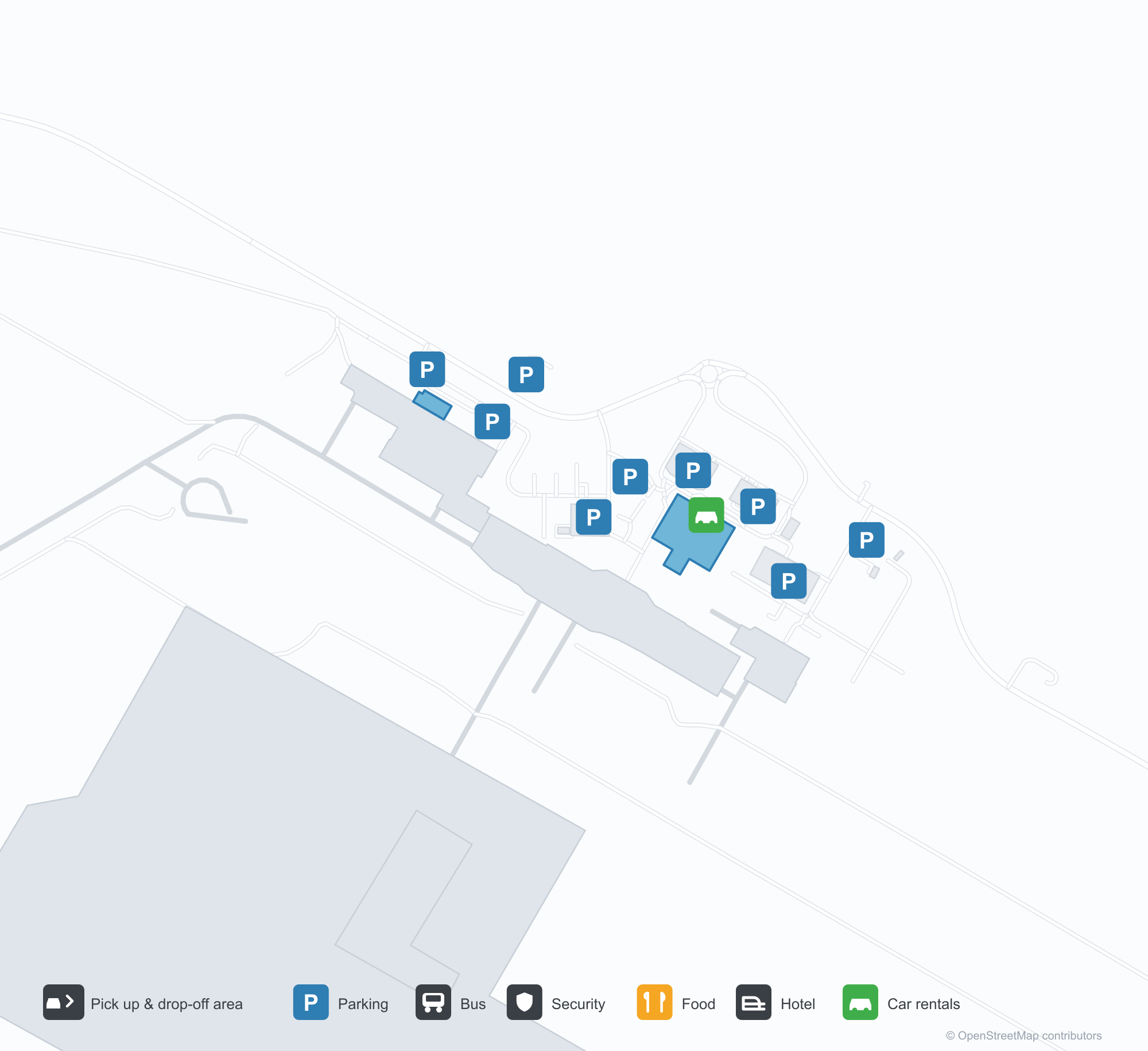
空港マップをダウンロードダウンロード
空港写真空港写真
この空港の実際の写真です。いずれも公開ウェブページを出典として明記しており、著作権は撮影者に帰属します。写真をクリックすると拡大表示され、クレジットをクリックすると元のページが開きます。
アリススプリングスの旧管制塔——ガラス張りの管制室の下のレンガの塔身、エプロンにはフォッカーF.27が待つ(1970年頃、写真:テリー・マーティン、CAHSコレクション、Airways Museum経由)。
空から見たアリススプリングス——赤い砂漠を横切る滑走路と誘導路、飛行場沿いに管制塔、ターミナル、エプロンが並ぶ(CAHSコレクション、Airways Museum経由)。
ターミナルの縁石沿いに赤い柱と白い日よけ布、ファサードの上にカンタスの看板、外には車と白いバンが待つ。
空撮:長い滑走路、誘導路、エプロンが浮かび、軽飛行機が数機停まる。赤い砂漠の地面にターミナル、格納庫、駐車場が点在する。
ヴァージン・オーストラリアの旅客機の赤い尾翼が後部エンジンの上に画面いっぱいに広がり、翼の下の黄色い野花の中に地上係員2人。
静かな出発ラウンジに黒い座席が並び、隣の旅行代理店カウンターはシャッターを下ろし、縞模様の壁パネルと磨かれた床が天井灯に照らされる。
空撮:赤土の駐機場に旅客機4機が並び、その先に低木を横切る滑走路、地平線には低い山並み。
カンタスリンクのリージョナルジェットが砂漠の滑走路から上昇し、赤い尾翼が澄んだ空に映える。乾いた草の向こうには保管中の旅客機2機。
ロビーにカンタスのチェックインカウンターが並び、赤い行列用バーが健康案内板へ蛇行し、床には青と黄色の模様のカーペット。
Alice Springs Airportの路線マップ — 直行便の目的地路線マップ
直行目的地8か所。地図、就航航空会社、距離を掲載しています。
Alice Springs Airport発着便 — 出発と到着フライトボード
便名63件、12社の航空会社、8か所の目的地を出発・到着別に掲載しています。コードシェア便も含みます。
| 便 | 航空会社 | 目的地 | 国・地域 |
|---|---|---|---|
| AA7273 | American Airlines | シドニー・キングスフォード・スミス空港 | オーストラリア |
| AS5140 | Alaska Airlines | シドニー・キングスフォード・スミス空港 | オーストラリア |
| CX9032 | Cathay Pacific | シドニー・キングスフォード・スミス空港 | オーストラリア |
| EK5079 | Emirates | Adelaide International Airport | オーストラリア |
| EK5373 | Emirates | シドニー・キングスフォード・スミス空港 | オーストラリア |
| EK5722 | Emirates | Adelaide International Airport | オーストラリア |
| NZ7036 | Air New Zealand | Melbourne Airport | オーストラリア |
| NZ7098 | Air New Zealand | Brisbane International Airport | オーストラリア |
| NZ7356 | Air New Zealand | Adelaide International Airport | オーストラリア |
| NZ7460 | Air New Zealand | Adelaide International Airport | オーストラリア |
| NZ7473 | Air New Zealand | Adelaide International Airport | オーストラリア |
| NZ7791 | Air New Zealand | シドニー・キングスフォード・スミス空港 | オーストラリア |
| QF791 | Qantas | シドニー・キングスフォード・スミス空港 | オーストラリア |
| QF1599 | Qantas | Melbourne Airport | オーストラリア |
| QF1817 | Qantas | Adelaide International Airport | オーストラリア |
| QF1875 | Qantas | Brisbane International Airport | オーストラリア |
| QF1955 | Qantas | Adelaide International Airport | オーストラリア |
| QF1959 | Qantas | ダーウィン (DRW) Darwin International Airport / RAAF Darwin | オーストラリア |
| QF1961 | Qantas | ダーウィン (DRW) Darwin International Airport / RAAF Darwin | オーストラリア |
| QF8657 | Qantas | ケアンズ (CNS) Cairns International Airport | オーストラリア |
便名と路線はaviability.comのフライトインデックス(スナップショット:2026年10月26日)に基づきます。コードシェア便を含み、出発時刻は掲載していません。出典:aviability.com ↗
空港情報と詳細空港の詳細
インタラクティブマップ — Alice Springs Airportの位置インタラクティブマップ
他の地図サービスでこの空港を見る:
Alice Springs Airport (ASP): From a 1970 Control Tower to a Red-Desert Runway空港ガイド
The photos of Alice Springs Airport (IATA ASP, ICAO YBAS) span half a century. One shows the old control tower around 1970 — a brick shaft under a glazed cab, with a Fokker F.27 turboprop waiting on the apron. The other is a current aerial: runways and taxiways laid across red desert, with the tower, terminal and apron lined up along the field. The frame has barely changed; only the aircraft have.
The airport serves Alice Springs in Australia's Northern Territory at an elevation of about 545 m. Its main runway, 12/30, is 2,438 m long, with a second 1,133 m strip (17/35). The 2014 route snapshot records 8 non-stop destinations, all within Australia.
Airport photos
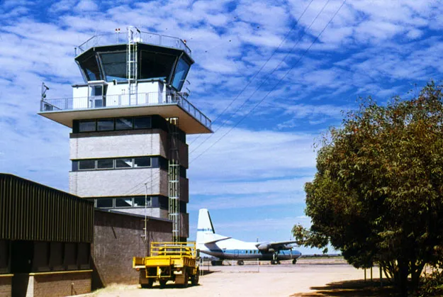
Alice Springs' old control tower — a brick shaft under the glazed cab, a Fokker F.27 waiting on the apron (c. 1970; photo Terry Martin, CAHS collection, via the Airways Museum).
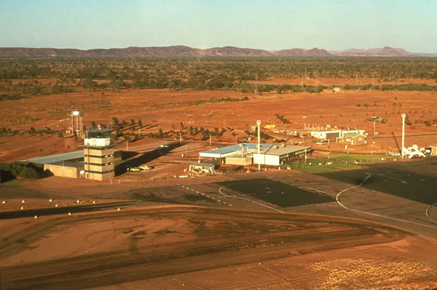
Alice Springs from the air — runways and taxiways laid across the red desert, the tower, terminal and apron lined up along the field (CAHS collection, via the Airways Museum).
The photos come from public web sources and remain the copyright of their photographers; full credits and source links sit in the photo gallery on this page.
Airport at a glance
| Item | Detail |
|---|---|
| IATA / ICAO | ASP / YBAS |
| Role | Medium-sized airport and regional gateway for central Australia |
| Elevation | about 545 m |
| Coordinates | -23.8066, 133.9034 |
| Runways | 2: 12/30 at 2,438 m, 17/35 at 1,133 m |
| Non-stop destinations | 8 (2014 snapshot, all domestic) |
| Official site | alicespringsairport.com.au |
Network shape: eight destinations, all listed for Qantas
By distance, only Ayers Rock (333 km) is within 1,000 km. The other 7 fall between 1,000 and 3,000 km, the farthest being Sydney (2,020 km), Perth (1,978 km) and Brisbane (1,965 km). This is a classic desert-spoke map: a short hop to Ayers Rock, then medium-haul links to Darwin, Adelaide, Melbourne, Perth and Sydney.
| Distance band | Destinations |
|---|---|
| Under 1,000 km | 1 |
| 1,000–3,000 km | 7 |
| Over 3,000 km | 0 |
All 8 routes list Qantas, with Tiger Airways Australia and American Airlines appearing on individual routes (including codeshares). The carrier column describes concentration, not who operates every flight. The full list is on the Alice Springs route map.
Getting there and navigating
- Coordinates: -23.8066, 133.9034
- Official site: alicespringsairport.com.au
- Open in a map: Google Maps | Amap | Baidu Maps
If your destination is not on the list, Adelaide (ADL) is the nearest larger alternative in the snapshot: about 1,317 km away with 25 destinations. Travellers heading to Ayers Rock can compare ASP and AYQ directly on distance and schedule.
The location map on this page shows the field against Alice Springs and the surrounding highway network. Terminal connections and local transport fall outside this dataset; the airport or airline can confirm them.
Before you fly
- Desert temperatures swing sharply between day and night, and summer heat is intense. The road into town is not short; a rental car or pre-booked transfer is more reliable than finding one on arrival.
- The 8 destinations are a 2014 snapshot. Qantas adjusts its central Australian schedule seasonally, so check the current timetable.
- The old tower and Fokker F.27 are historical images, not evidence of today's operators. If you plan to photograph aircraft, confirm the airport's spotting rules first.
About the data
Runways, elevation and coordinates come from OurAirports open data. Routes and carriers come from the June 2014 OpenFlights snapshot and include codeshares and interline services; they indicate network shape and scale, not current schedules. Historical photos are from the CAHS collection via the Airways Museum and remain the copyright of their photographers.
読者コメントディスカッション
質問、旅行記、訂正など、お気軽にお寄せください。コメントは公開されます。
読み込み中…
コメントを読み込み中…