
Armidale Airport
 Armidale · Australia· Armidale Airport
Armidale Airport (IATA: ARM, ICAO YARM) adalah bandara sedang yang melayani Armidale, Australia.
Armidale Airport is a medium-sized airport, at an elevation of about 3,556 ft, with scheduled passenger service. This page gathers its location map, airport codes and travel information.
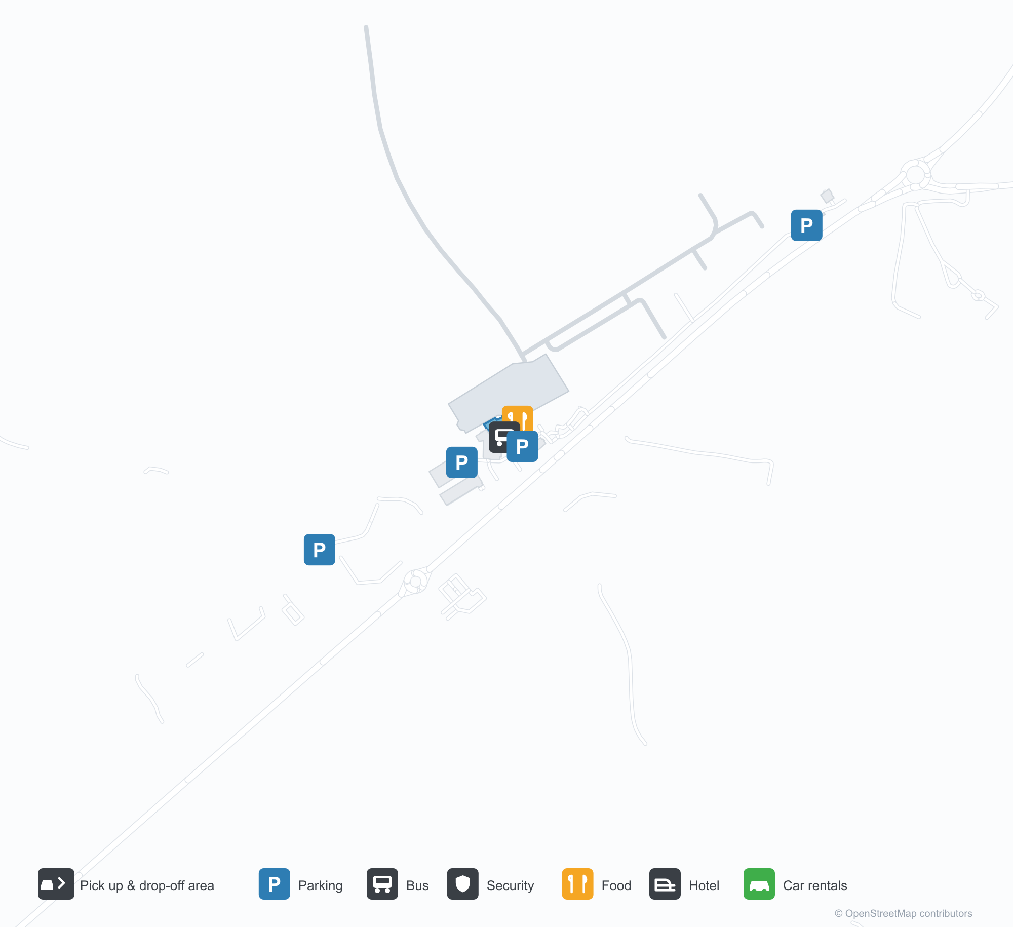
Unduh Peta BandaraUnduhan
Foto bandaraFoto Bandara
Foto asli bandara ini, masing-masing dikreditkan ke halaman web publik tempat foto ditemukan; hak cipta tetap milik fotografer aslinya. Klik foto untuk memperbesar, atau baris kredit untuk membuka halaman sumbernya.
Citra satelit: landasan pacu Armidale terletak di antara perbukitan dan lahan pertanian di dataran tinggi New England, dengan terminal dan apron di samping lapangan.
Di bawah langit mendung, dua pelancong mendorong koper melewati pintu masuk kaca terminal kelabu rendah Bandara Regional Armidale.
Dari udara, landasan pacu membentang lurus melewati padang hijau sementara taxiway lingkar yang baru diaspal melengkung di sekitar apron dan hanggarnya.
Saat senja, pesawat turboprop bermesin ganda beristirahat di apron di samping terminal berdinding kaca, bayangannya membentang di aspal gelap.
Ujung atap pelana gelap terminal berkaca dari atap hingga tanah, dengan panel seni berwarna karat berdiri di samping jalur bata merah.
Lampu hangat bersinar di bawah kanopi terminal saat malam tiba, sementara ekor pesawat di apron jauh menangkap cahaya terakhir.
Di dalam aula check-in yang kosong, petugas berseragam bersandar di meja di bawah layar bertanda Qantas dan Link Airways.
Di bawah langit biru cerah, penumpang turun dari pesawat turboprop QantasLink ke apron sementara petugas darat menunggu di samping sayap.
Peta rute Armidale Airport — tujuan langsungPeta Rute
1 tujuan langsung: peta, maskapai yang beroperasi, dan jarak.
Penerbangan Armidale Airport — keberangkatan & kedatanganPapan Penerbangan
52 nomor penerbangan dari 6 maskapai dan 3 tujuan, dipisahkan menurut arah. Nomor codeshare disertakan.
| Penerbangan | Maskapai | Tujuan | Negara/wilayah |
|---|---|---|---|
| EK5118 | Emirates | Bandara Sydney Kingsford Smith | Australia |
| EK5154 | Emirates | Bandara Sydney Kingsford Smith | Australia |
| EK5170 | Emirates | Bandara Sydney Kingsford Smith | Australia |
| EK5190 | Emirates | Bandara Sydney Kingsford Smith | Australia |
| EK5194 | Emirates | Bandara Sydney Kingsford Smith | Australia |
| FC884 | Link Airways | Brisbane International Airport | Australia |
| FC5184 | Link Airways | Brisbane International Airport | Australia |
| FC8154 | Link Airways | Coffs Harbour (CFS) Coffs Harbour Airport | Australia |
| MU4056 | China Eastern Airlines | Bandara Sydney Kingsford Smith | Australia |
| NZ7015 | Air New Zealand | Bandara Sydney Kingsford Smith | Australia |
| NZ7017 | Air New Zealand | Bandara Sydney Kingsford Smith | Australia |
| NZ7222 | Air New Zealand | Bandara Sydney Kingsford Smith | Australia |
| NZ7265 | Air New Zealand | Bandara Sydney Kingsford Smith | Australia |
| NZ7448 | Air New Zealand | Bandara Sydney Kingsford Smith | Australia |
| NZ7478 | Air New Zealand | Bandara Sydney Kingsford Smith | Australia |
| QF2019 | Qantas | Bandara Sydney Kingsford Smith | Australia |
| QF2021 | Qantas | Bandara Sydney Kingsford Smith | Australia |
| QF2023 | Qantas | Bandara Sydney Kingsford Smith | Australia |
| QF2025 | Qantas | Bandara Sydney Kingsford Smith | Australia |
| QF2031 | Qantas | Bandara Sydney Kingsford Smith | Australia |
Nomor penerbangan dan rute dari indeks penerbangan aviability.com (cuplikan 26 Oktober 2026); nomor codeshare disertakan dan waktu keberangkatan tidak ditampilkan. Sumber: aviability.com ↗
Informasi & detail bandaraDetail Bandara
Peta interaktif — lokasi Armidale AirportPeta Interaktif
Lihat bandara ini di layanan peta lain:
Armidale Airport (ARM): One Domestic Route on the New England TablelandsPanduan Bandara
Seen from above, Armidale's runways lie among hills and farmland on the New England tablelands, with the terminal and apron alongside the field. The airport serves Armidale in New South Wales, Australia, at an elevation of about 1,084 m, with runways up to 1,738 m; Armidale is a university and farming town on the New England tablelands, and its route map is short — only Sydney (382 km), the link to the national network.
Satellite view
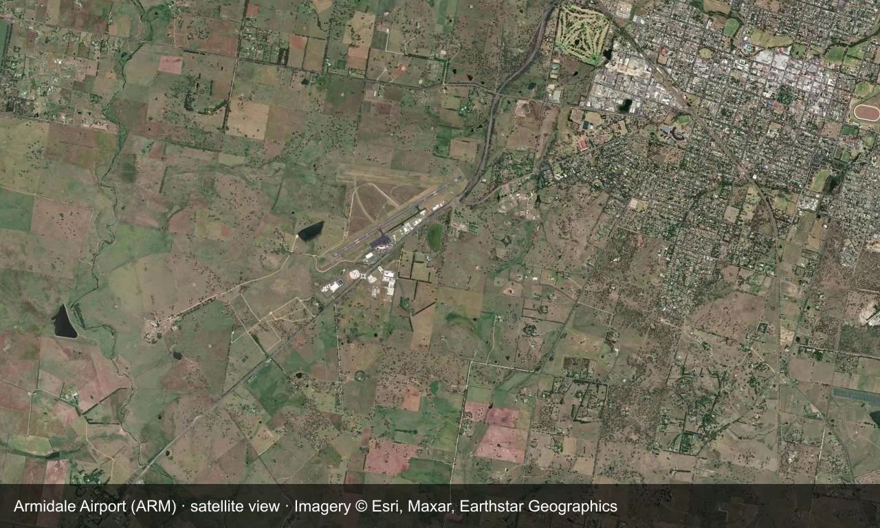
Satellite view: Armidale's runways lie among hills and farmland on the New England tablelands, with the terminal and apron alongside the field.
The satellite image comes from Esri World Imagery (© Esri, Maxar, Earthstar Geographics); the field and attribution are labelled in the image. This is a satellite view, not a ground-level photograph.
Airport at a glance
| Item | Detail |
|---|---|
| IATA / ICAO | ARM / YARM |
| Role | Medium-sized airport |
| Elevation | about 1,084 m |
| Coordinates | -30.5281, 151.6170 |
| Runways | 2, longest 1,738 m |
| Non-stop destinations | 1 (Sydney; 2014 snapshot) |
Runways
| Runway | Length | Width | Surface |
|---|---|---|---|
| 05/23 | 1,738 m | 30 m | asphalt |
| 09/27 | 1,116 m | 30 m | GVL |
2 runways, the longest 1,738 m.
Non-stop routes
1 non-stop destinations, nearest first (OpenFlights route snapshot compiled in 2014 — confirm with the airline or airport):
| Destination | Distance | Carriers |
|---|---|---|
| Sydney Kingsford Smith International Airport (SYD) | ~382 km | Qantas, Regional Express |
The carrier column comes from the same snapshot and includes codeshare and interline services; treat it as an indication of how busy the route is and check the airline for who actually flies it.
Nearby airports to compare
If the fares are close, these are the nearest airports of the same class (medium-sized airport) — straight-line distance, with their own non-stop counts from the same dataset:
| Airport | Distance | Non-stop destinations |
|---|---|---|
| Albury Airport (ABX) | ~753 km | 2 |
Before you fly
- With only Sydney, confirm the flight is operating after booking.
- Tableland winters are cold, with morning frost and low cloud possible.
About the data
Runways, elevation and coordinates come from OurAirports open data. Routes and carriers come from the June 2014 OpenFlights snapshot and include codeshares and interline services; they indicate network shape and scale, not current schedules.
Komentar pembacaDiskusi
Pertanyaan, laporan perjalanan, dan koreksi sangat kami harapkan. Komentar bersifat publik.
Memuat…
Memuat komentar…