
Clermont-Ferrand Auvergne airport
 Clermont-Ferrand · ฝรั่งเศส· Clermont-Ferrand Auvergne airport
Clermont-Ferrand Auvergne airport (IATA: CFE, ICAO LFLC) เป็นสนามบินขนาดใหญ่ที่ให้บริการClermont-Ferrand, ฝรั่งเศส
Clermont-Ferrand Auvergne airport is a large airport, at an elevation of about 1,090 ft, with scheduled passenger service. This page gathers its location map, airport codes and travel information.
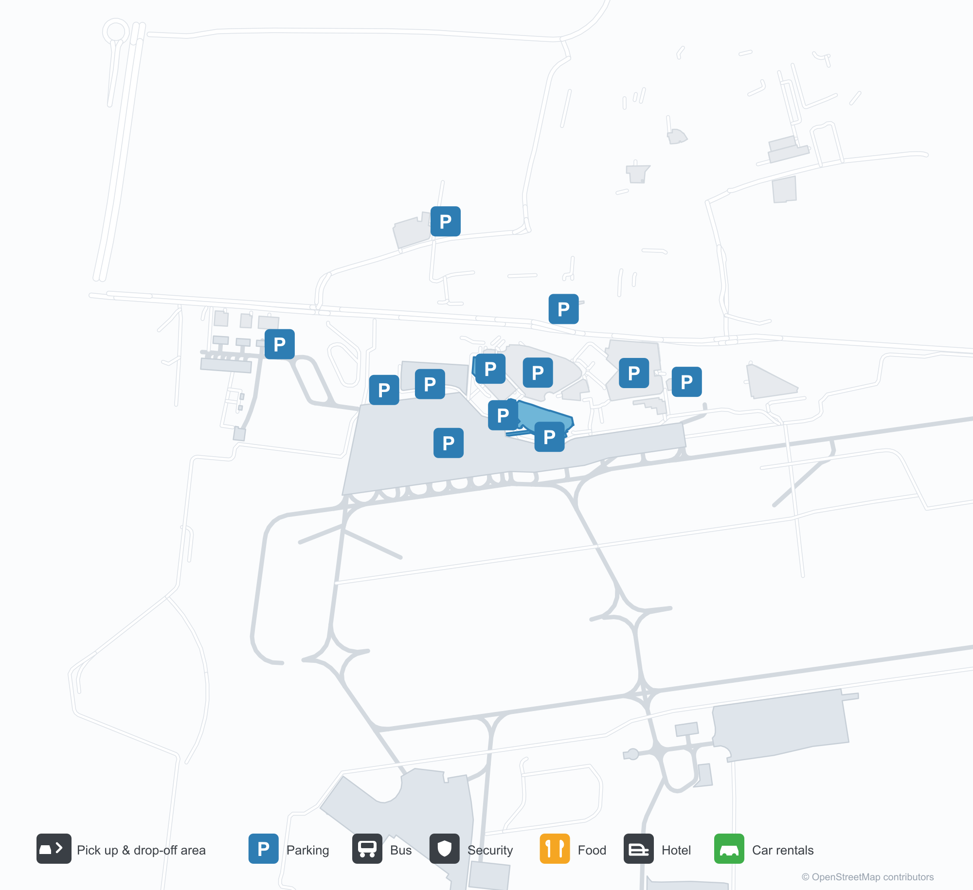
ดาวน์โหลดแผนที่สนามบินดาวน์โหลด
ภาพสนามบินภาพสนามบิน
ภาพจริงของสนามบินแห่งนี้ พร้อมเครดิตของหน้าเว็บสาธารณะที่พบภาพ; ลิขสิทธิ์ยังเป็นของผู้ถ่ายภาพต้นฉบับ คลิกที่ภาพเพื่อขยาย หรือคลิกบรรทัดเครดิตเพื่อเปิดหน้าแหล่งที่มา
อาคารผู้โดยสารการบินธุรกิจ — ข้อความ 'départs / departures' พาดผ่านด้านหน้าสีเข้ม มีประตูหมุนและช่องจอดส่งผู้โดยสารอยู่ด้านหน้า
เครื่องบินธุรกิจ Dassault Falcon บนลานจอด โดยมีหอบังคับการบินและอาคารผู้โดยสารอยู่ด้านหลัง
ประติมากรรมเครื่องบินสองปีกตั้งอยู่บนเสากลางวงเวียนจอดส่งผู้โดยสาร ขณะที่ผู้เดินทางเข็นกระเป๋าไปยังอาคารผู้โดยสารด้านหน้ากระจก
มองจากที่สูง ทางเดินยื่นออกจากอาคารหลักไปยังลานจอด มีอากาศยานขนาดเล็กไม่กี่ลำจอดอยู่ และเมืองหลังคาสีแดงอยู่ไกลออกไป
ผู้โดยสารปีนบันไดเคลื่อนที่ขึ้นเครื่องบิน ขณะที่เจ้าหน้าที่ภาคพื้นในเสื้อสะท้อนแสงยืนอยู่ข้าง ๆ โดยมีป้ายชื่ออาคารผู้โดยสารอยู่เหนือพวกเขา
ภาพถ่ายทางอากาศที่มีคำอธิบายของสนามบินแสดงทางวิ่งหญ้าและทางวิ่งปูพื้น โดยมีเครื่องบินเบาไม่กี่ลำจอดอยู่ข้างทุ่งนาทางซ้าย
มองลงมา อาคารผู้โดยสารและลานจอดรถที่แน่นขนัดล้อมลานจอดที่มีเครื่องบินโดยสารสองลำ โดยมีอนุสาวรีย์เครื่องบินสองปีกอยู่บนเกาะวงเวียน
เครื่องบินเจ็ตภูมิภาค Air France HOP พักอยู่บนลานจอด ขณะที่รถบรรทุกสัมภาระและรถภาคพื้นทำงานอยู่ข้างลำ โดยมีเนินเขาอยู่ไกลออกไป
ผู้เดินทางพร้อมเป้เดินผ่านประตูหมุนใต้ตัวอักษร 'départs' สีเหลืองบนหลังคากันแดดสีเข้มของอาคารผู้โดยสาร
แผนที่เส้นทาง Clermont-Ferrand Auvergne airport — จุดหมายบินตรงแผนที่เส้นทาง
6 จุดหมายบินตรง: แผนที่ สายการบินที่ให้บริการ และระยะทาง
เที่ยวบินของClermont-Ferrand Auvergne airport — ขาออกและขาเข้าป้ายเที่ยวบิน
56 หมายเลขเที่ยวบิน ครอบคลุม 12 สายการบิน และ 3 จุดหมายปลายทาง แยกตามทิศทาง หมายเลขเที่ยวบินร่วม (codeshare) รวมอยู่ด้วย
| เที่ยวบิน | สายการบิน | จุดหมายปลายทาง | ประเทศ/ภูมิภาค |
|---|---|---|---|
| 5O133 | ASL Airlines France | แอลเจียร์ (ALG) Houari Boumediene Airport | แอลจีเรีย |
| AF7391 | Air France | ท่าอากาศยานปารีสชาร์ลเดอโกล | ฝรั่งเศส |
| AF7393 | Air France | ท่าอากาศยานปารีสชาร์ลเดอโกล | ฝรั่งเศส |
| AF7395 | Air France | ท่าอากาศยานปารีสชาร์ลเดอโกล | ฝรั่งเศส |
| AM5819 | Aeroméxico | ท่าอากาศยานปารีสชาร์ลเดอโกล | ฝรั่งเศส |
| AM5828 | Aeroméxico | ท่าอากาศยานปารีสชาร์ลเดอโกล | ฝรั่งเศส |
| AM6134 | Aeroméxico | ท่าอากาศยานปารีสชาร์ลเดอโกล | ฝรั่งเศส |
| DL8350 | Delta Air Lines | ท่าอากาศยานปารีสชาร์ลเดอโกล | ฝรั่งเศส |
| DL8612 | Delta Air Lines | ท่าอากาศยานปารีสชาร์ลเดอโกล | ฝรั่งเศส |
| DL8613 | Delta Air Lines | ท่าอากาศยานปารีสชาร์ลเดอโกล | ฝรั่งเศส |
| G35066 | Gol Airlines | ท่าอากาศยานปารีสชาร์ลเดอโกล | ฝรั่งเศส |
| KL2027 | KLM | ท่าอากาศยานปารีสชาร์ลเดอโกล | ฝรั่งเศส |
| KL2029 | KLM | ท่าอากาศยานปารีสชาร์ลเดอโกล | ฝรั่งเศส |
| KL2455 | KLM | ท่าอากาศยานปารีสชาร์ลเดอโกล | ฝรั่งเศส |
| KQ3080 | Kenya Airways | ท่าอากาศยานปารีสชาร์ลเดอโกล | ฝรั่งเศส |
| MK9031 | Air Mauritius | ท่าอากาศยานปารีสชาร์ลเดอโกล | ฝรั่งเศส |
| MK9035 | Air Mauritius | ท่าอากาศยานปารีสชาร์ลเดอโกล | ฝรั่งเศส |
| MU1506 | China Eastern Airlines | ท่าอากาศยานปารีสชาร์ลเดอโกล | ฝรั่งเศส |
| MU1534 | China Eastern Airlines | ท่าอากาศยานปารีสชาร์ลเดอโกล | ฝรั่งเศส |
| V72268 | Volotea | Francisco de Sá Carneiro Airport | โปรตุเกส |
หมายเลขเที่ยวบินและเส้นทางจากดัชนีเที่ยวบิน aviability.com (ข้อมูล ณ วันที่ 26 ตุลาคม 2569); รวมหมายเลขเที่ยวบินร่วมและไม่แสดงเวลาเดินทาง ที่มา: aviability.com ↗
ข้อมูลและรายละเอียดสนามบินรายละเอียดสนามบิน
แผนที่อินเทอร์แอกทีฟ — ตำแหน่ง Clermont-Ferrand Auvergne airportแผนที่อินเทอร์แอกทีฟ
ดูสนามบินนี้บนบริการแผนที่อื่น:
Clermont-Ferrand Airport (CFE): Business Aviation and Six Routesคู่มือสนามบิน
The photos of Clermont-Ferrand Auvergne airport (IATA CFE, ICAO LFLC) do not show the main terminal. They focus on business aviation: a dark façade carrying the words "départs · departures", a revolving door and a drop-off lane in front; then a Dassault Falcon on the apron with the control tower and terminal behind it. This is not an airport that runs on scheduled flights alone — business and general aviation have a real place here.
The field serves Clermont-Ferrand, France, at an elevation of about 332 m. Its main runway, 08/26, is 3,013 m of asphalt; the other two are grass strips of 900 m and 705 m. The 2014 route snapshot records only 6 non-stop destinations: 4 in France and 2 abroad.
Airport photos
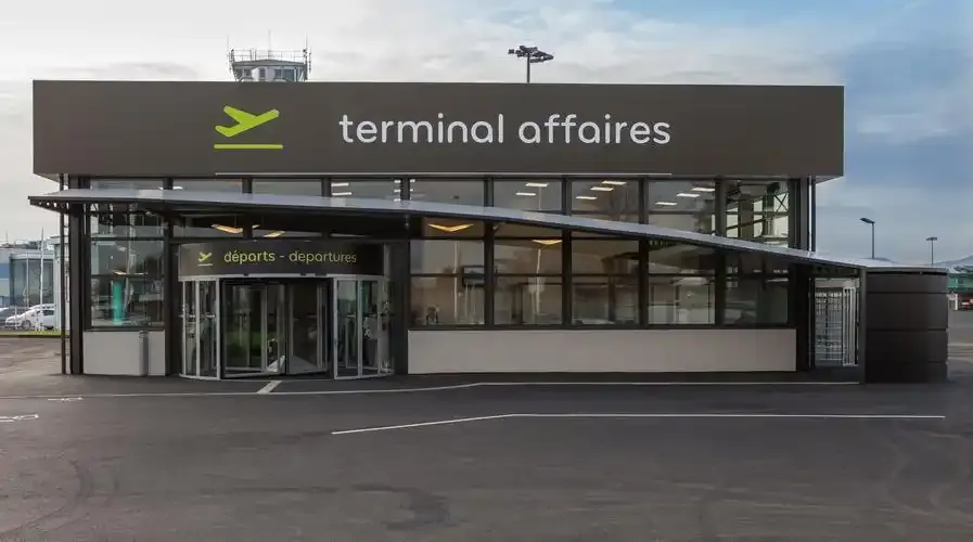
The business-aviation terminal — 'départs / departures' across its dark façade, a revolving door and drop-off lane in front.
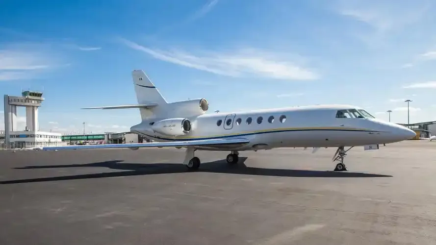
A Dassault Falcon business jet on the apron, with the control tower and terminal behind it.
The photos come from public web sources and remain the copyright of their photographers; full credits and source links sit in the photo gallery on this page.
Airport at a glance
| Item | Detail |
|---|---|
| IATA / ICAO | CFE / LFLC |
| Role | Large airport by this site's classification; regional gateway for Auvergne |
| Elevation | about 332 m |
| Coordinates | 45.7867, 3.1692 |
| Runways | 3: 08/26 at 3,013 m asphalt; 08L/26R at 900 m grass; 01/19 at 705 m grass |
| Non-stop destinations | 6 (4 domestic, 2 international; 2014 snapshot) |
| Official site | clermont-aeroport.com |
Network shape: six routes, five within 1,000 km
By distance: 5 destinations within 1,000 km, 1 between 1,000 and 3,000 km, and none beyond 3,000 km. The near layer is Lyon (149 km), Paris Orly (333 km) and Paris Charles de Gaulle (361 km); the only route over 1,000 km is Porto at 1,079 km. Air France and Airlinair each appear on 3 routes; the carrier column includes codeshares, so the figures describe concentration.
| Distance band | Destinations |
|---|---|
| Under 1,000 km | 5 |
| 1,000–3,000 km | 1 |
| Over 3,000 km | 0 |
Those six routes are all the 2014 snapshot recorded, not proof that the airport serves only six places today; seasonal and charter flights may be missing. The full list is on the Clermont-Ferrand route map.
Getting there and navigating
- Coordinates: 45.7867, 3.1692
- Official site: clermont-aeroport.com
- Open in a map: Google Maps | Amap | Baidu Maps
If fares are close, compare the two Paris airports: Orly (ORY) is about 333 km away with 109 destinations, and Charles de Gaulle (CDG) about 361 km away with 234. The snapshot also shows a CFE–Lyon route (149 km), making Lyon the nearest regional alternative.
The location map on this page shows the field against Clermont-Ferrand and the road network. This page does not cover terminal connections or local transport; confirm them with the airport or airline.
Before you fly
- The airport is small, so 90 minutes before departure is usually enough; add time for an international flight or checked bags.
- The "départs" entrance in the photos belongs to the business-aviation terminal, not the scheduled-flight terminal. Confirm which building you need before setting off.
- The two grass strips serve light aircraft; scheduled flights use the 3,013 m asphalt runway. The six routes are a 2014 snapshot, so check current schedules.
About the data
Runways, elevation and coordinates come from OurAirports open data. Routes and carriers come from the June 2014 OpenFlights snapshot and include codeshares and interline services; they indicate network shape and scale, not current schedules. Photos are from public web sources and remain the copyright of their photographers.
ความคิดเห็นจากผู้อ่านการสนทนา
ยินดีรับคำถาม รายงานการเดินทาง และการแก้ไข ความคิดเห็นเป็นสาธารณะ
กำลังโหลด…
กำลังโหลดความคิดเห็น…