
Anaa Airport
 Anaa · フランス領ポリネシア· Anaa Airport
Anaa Airport(IATA: AAA、ICAO: NTGA)はAnaa、フランス領ポリネシアにある中型空港です。
Anaa Airport is a medium-sized airport, at an elevation of about 10 ft, with scheduled passenger service. This page gathers its location map, airport codes and travel information.
空港マップをダウンロードダウンロード
空港写真空港写真
この空港の実際の写真です。いずれも公開ウェブページを出典として明記しており、著作権は撮影者に帰属します。写真をクリックすると拡大表示され、クレジットをクリックすると元のページが開きます。
国際宇宙ステーションから撮影したアナア環礁(NASAの画像 ISS007-E-14624、パブリックドメイン)——細長い環礁、白いリーフの縁、ターコイズ色のラグーンが見え、空港は中央の小島にある。
Anaa Airport発着便 — 出発と到着フライトボード
便名6件、1社の航空会社、3か所の目的地を出発・到着別に掲載しています。コードシェア便も含みます。
便名と路線はaviability.comのフライトインデックス(スナップショット:2026年10月26日)に基づきます。コードシェア便を含み、出発時刻は掲載していません。出典:aviability.com ↗
空港情報と詳細空港の詳細
インタラクティブマップ — Anaa Airportの位置インタラクティブマップ
他の地図サービスでこの空港を見る:
Anaa Airport (AAA): An Atoll Airport Seen From Space空港ガイド
The photo comes from the International Space Station: the long, narrow Anaa atoll, its white reef edge and turquoise lagoon are clearly visible, and the airport sits on the main islet in the frame. The field serves Anaa in French Polynesia at an elevation of about 3 m, with a 1,500 m runway; the 2014 snapshot records no scheduled routes.
Airport photos
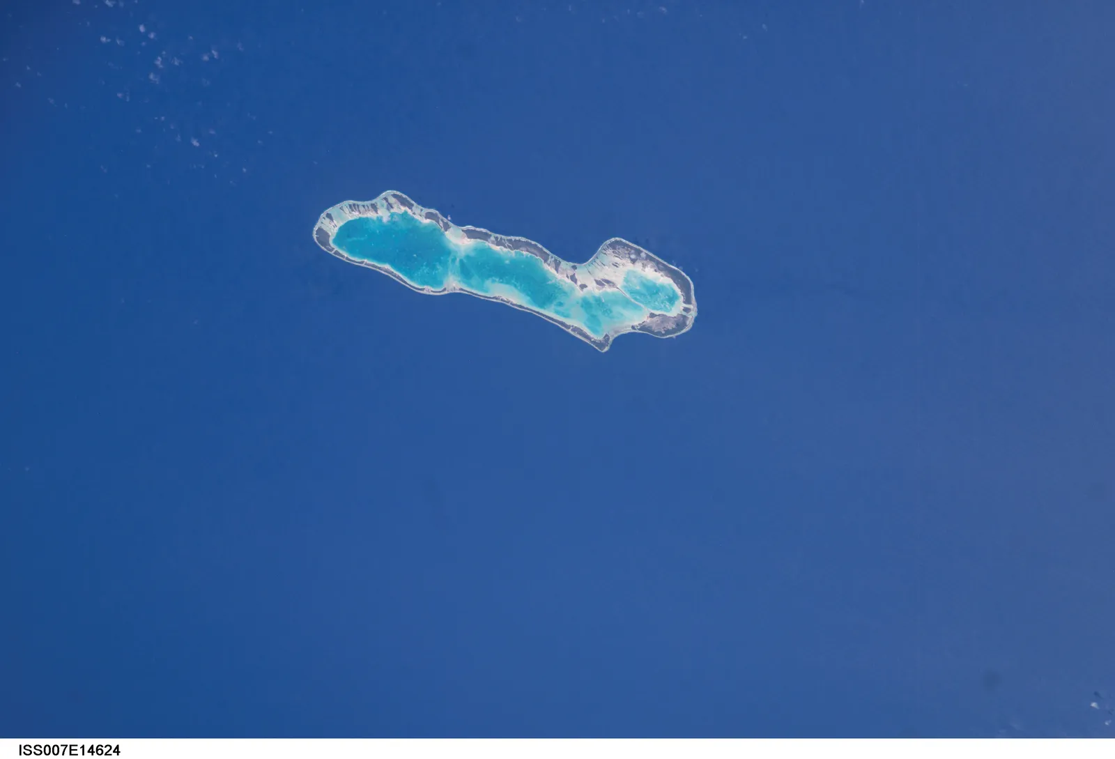
Anaa atoll photographed from the International Space Station (NASA image ISS007-E-14624, public domain) — the narrow atoll with its white reef edge and turquoise lagoon; the airport sits on the main islet.
The photos come from public web sources and remain the copyright of their photographers; full credits and source links sit in the photo gallery on this page.
Airport at a glance
| Item | Detail |
|---|---|
| IATA / ICAO | AAA / NTGA |
| Role | Medium-sized airport |
| Elevation | about 3 m |
| Coordinates | -17.3526, -145.5100 |
| Runways | 1, 1,500 m |
| Non-stop destinations | 0 in the 2014 snapshot |
Runways
| Runway | Length | Width | Surface |
|---|---|---|---|
| 14/32 | 1,500 m | 18 m | asphalt |
1 runway, the longest 1,500 m.
Non-stop routes
The route dataset carries no scheduled non-stop services for this airport. Regional schedules change often — confirm with the airline or airport before booking.
Nearby airports to compare
If the fares are close, these are the nearest airports of the same class (medium-sized airport) — straight-line distance, with their own non-stop counts from the same dataset:
| Airport | Distance | Non-stop destinations |
|---|---|---|
| Arutua Airport (AXR) | ~262 km | 1 |
| Ahe Airport (AHE) | ~335 km | 2 |
Before you fly
- Atoll schedules are usually run by regional carriers; an empty 2014 snapshot does not mean no flights today, so check the airline directly.
- With a 1,500 m runway, aircraft and payloads are limited; baggage and supplies follow small-aircraft rules.
About the data
Runways, elevation and coordinates come from OurAirports open data. Routes and carriers come from the June 2014 OpenFlights snapshot and include codeshares and interline services; they indicate network shape and scale, not current schedules.
読者コメントディスカッション
質問、旅行記、訂正など、お気軽にお寄せください。コメントは公開されます。
読み込み中…
コメントを読み込み中…