
Antoine-Simon International Airport
 Les Cayes · Haiti· Antoine-Simon International Airport
Antoine-Simon International Airport (IATA: CYA, ICAO MTCA), Les Cayes, Haiti kentine hizmet veren bir orta büyüklükte havalimanıdır.
Antoine-Simon International Airport is a medium-sized airport, at an elevation of about 203 ft, with scheduled passenger service. This page gathers its location map, airport codes and travel information.
Havalimanı Haritalarını İndirinİndirmeler
Havalimanı fotoğraflarıHavalimanı Fotoğrafları
Bu havalimanının gerçek fotoğrafları; her fotoğrafın altında, fotoğrafın bulunduğu kamuya açık web sayfasına bir atıf yer alır ve telif hakkı özgün fotoğrafçılarda kalır. Yakınlaştırmak için bir fotoğrafa, kaynak sayfasını açmak için bir atıf satırına tıklayın.
Uydu görüntüsünde Antoine-Simon Uluslararası Havalimanı'nın (CYA) pisti kasaba, tarım arazileri ve bitki örtüsü arasında yer alıyor.
Soluk yeşil bir tente altındaki beyaz tabela, Les Cayes'teki Antoine Simon Uluslararası Havalimanı'na Fransızca hoş geldiniz yazıyor; altından insanlar geçiyor.
Kapalı gökyüzü altında arka motorlu ve T kuyruklu beyaz bir bölgesel jet, koyu asfalt apron boyunca yeşil ağaç duvarının önünden taksi yapıyor.
Parlak öğle güneşi altında küçük yeşil-beyaz tek motorlu bir turboprop beton apronda duruyor; kabin kapısı açık, merdivende bir kişi var.
Mavi-beyaz bir bölgesel jet, su topu selamlaması eşliğinde ıslak pist boyunca ilerliyor; çimenden iki itfaiyeci koyu kıyafetleriyle hortumları doğrultuyor.
Aeroport Antoine Simon des Cayes yazılı mavi bir tabela tel örgü çitin yanında duruyor; parlak gökyüzünde kümülüs bulutları, yanında bir palmiye ve pembe zakkum çiçekleri var.
Batan güneş, duvarında Les Cayes Airport yazan küçük beyaz terminalin arkasındaki apronu altın rengine boyuyor; girişin yanında birkaç yolcu duruyor.
Soluk nane yeşili varış girişi, iki aşağı okun üzerinde Arrivee yazılı beyaz bir tabela taşıyor; önünde mavi korkuluklar ve çalılar var.
Antoine-Simon International Airport uçuşları — kalkışlar ve varışlarUçuş Panosu
15 uçuş numarası, 1 havayolu şirketi ve 2 varış noktası, yönlere göre ayrılmıştır. Ortak uçuş numaraları dahildir.
| Uçuş | Havayolu şirketi | Varış noktası | Ülke/bölge |
|---|---|---|---|
| S630 | Sunrise Airways | Port-au-Prince (PAP) Toussaint Louverture International Airport | Haiti |
| S632 | Sunrise Airways | Port-au-Prince (PAP) Toussaint Louverture International Airport | Haiti |
| S640 | Sunrise Airways | Cap Haitien (CAP) Cap Haitien International Airport | Haiti |
| S642 | Sunrise Airways | Cap Haitien (CAP) Cap Haitien International Airport | Haiti |
| S644 | Sunrise Airways | Cap Haitien (CAP) Cap Haitien International Airport | Haiti |
| S646 | Sunrise Airways | Cap Haitien (CAP) Cap Haitien International Airport | Haiti |
| S648 | Sunrise Airways | Cap Haitien (CAP) Cap Haitien International Airport | Haiti |
| S62030 | Sunrise Airways | Port-au-Prince (PAP) Toussaint Louverture International Airport | Haiti |
Uçuş numaraları ve rotalar aviability.com uçuş dizininden (anlık görüntü: 26 Ekim 2026); ortak uçuş numaraları dahildir ve kalkış saatleri gösterilmez. Kaynak: aviability.com ↗
Havalimanı bilgileri ve ayrıntılarıHavalimanı Ayrıntıları
Etkileşimli harita — Antoine-Simon International Airport konumuEtkileşimli Harita
Bu havalimanını diğer harita hizmetlerinde görüntüleyin:
Antoine-Simon International Airport (CYA) Guide: A regional runway in contextHavalimanı Rehberi
Satellite imagery of Antoine-Simon International Airport (CYA) in Haiti shows a field surrounded by a patchwork of vegetation and open ground. At about 62 m above sea level, it has a single 981 m runway. The 2014 snapshot lists no scheduled destinations; Jérémie Airport is 59.4 km away.
Satellite view
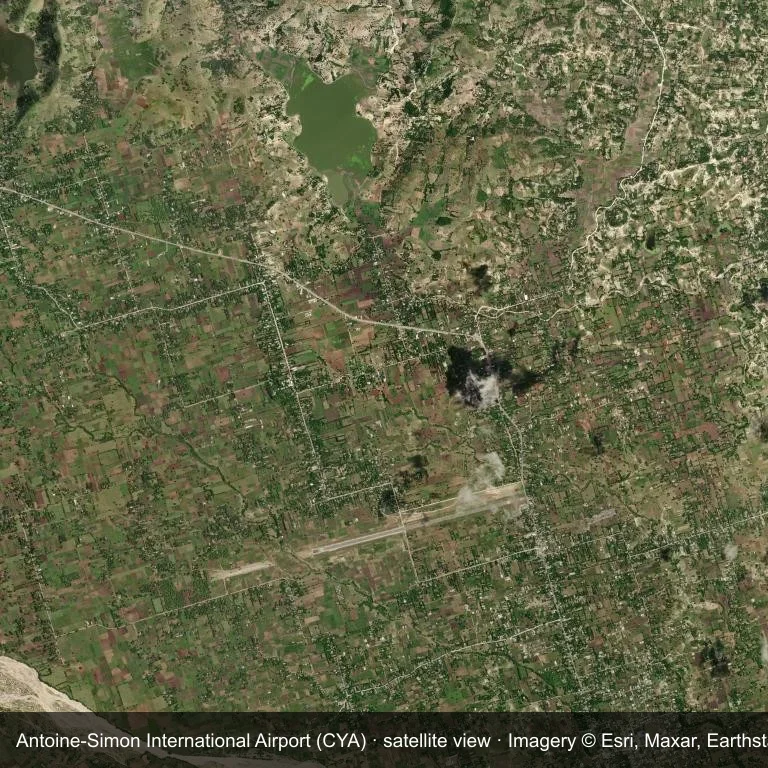
Satellite view of Antoine-Simon International Airport (CYA), with the airfield visible among a patchwork of vegetation and open ground.
Imagery: Esri World Imagery (© Esri, Maxar, Earthstar Geographics), with attribution in the image. It shows the field from orbit, not from the ground.
Airport at a glance
| Item | Detail |
|---|---|
| IATA / ICAO | CYA / MTCA |
| Role | medium-sized airport |
| Elevation | about 62 m |
| Coordinates | 18.2711, -73.7883 |
| Runways | 1, longest 981 m |
| Non-stop destinations | 0 in the 2014 snapshot |
Runways
| Runway | Length | Surface |
|---|---|---|
| 08/26 | 981 m | ASP |
Why there is no route table
The 2014 OpenFlights snapshot contains no scheduled services for CYA. Absence from that dataset is not proof that the field is unused today; check current airport and airline information before travelling.
Nearby airports
| Airport | Distance | Non-stop destinations |
|---|---|---|
| Jérémie Airport (JEE) | ~59.4 km | — |
| Toussaint Louverture International Airport (PAP) | ~161 km | 12 |
| Cap Haitien International Airport (CAP) | ~232 km | 2 |
Getting there and navigating
- Coordinates: 18.2711, -73.7883
- Open in a map: Google Maps | Amap | Baidu Maps
The location map on this page places the field in relation to nearby towns and roads. Terminal connections and local transport fall outside this dataset; the airport or airline can confirm them.
Airport sketch
Antoine-Simon International Airport occupies ground in Haiti surrounded by a patchwork of vegetation and open ground. The 08/26 runway runs east–west and offers 981 m of asphalt; elevation is about 62 m.
The runway gives 981 m of asphalt, a turboprop and light-jet profile. The paved surface supports regular operations, though it does not imply scheduled service. Jérémie Airport is 59.4 km away, with no recorded destinations in the same snapshot.
With no routes in the 2014 data, this is not a reliable scheduled destination. Use Jérémie Airport as the nearest back-up and verify access with the airport operator.
Before you fly
- The 981 m runway limits operations to small aircraft; baggage and payload limits are usually strict.
- The runway is paved, which supports year-round operations, but scheduled service is still not guaranteed.
- Jérémie Airport is the nearest airport in this dataset, 59.4 km away, but it also has no recorded destinations for 2014.
- The site has no terminal guide on this page, so allow extra time for local arrangements and onward transport.
- Treat this as a general-aviation or charter field rather than a large terminal; confirm handling and opening hours in advance.
About the data
Runways, elevation and coordinates come from OurAirports open data; routes come from the June 2014 OpenFlights snapshot. That snapshot describes network shape and scale, not current schedules.
Okuyucu yorumlarıTartışma
Sorular, seyahat deneyimleri ve düzeltmeler memnuniyetle karşılanır. Yorumlar herkese açıktır.
Yükleniyor…
Yorumlar yükleniyor…