
Antoine-Simon International Airport
 Les Cayes · Гаити· Antoine-Simon International Airport
Antoine-Simon International Airport (IATA: CYA, ICAO MTCA) — аэропорт среднего размера в городе Les Cayes, Гаити.
Antoine-Simon International Airport is a medium-sized airport, at an elevation of about 203 ft, with scheduled passenger service. This page gathers its location map, airport codes and travel information.
Скачать карты аэропортаЗагрузки
Фотографии аэропортаФото аэропорта
Реальные фотографии этого аэропорта; у каждой указан источник — общедоступная веб-страница. Авторские права принадлежат фотографам. Нажмите на фото, чтобы увеличить, или на подпись, чтобы открыть источник.
На спутниковом снимке полоса международного аэропорта Антуан-Симон (CYA) лежит между городом, сельхозугодьями и растительностью.
Белая вывеска под бледно-зелёным навесом по-французски приветствует гостей международного аэропорта Антуан-Симон в Ле-Ке, под ней проходят люди.
Под пасмурным небом белый региональный самолёт с задними двигателями и Т-образным хвостом рулит по тёмному асфальтовому перрону мимо стены зелёных деревьев.
В ярком полуденном солнце небольшой зелёно-белый одномоторный турбовинтовой самолёт стоит на бетонном перроне, дверь кабины открыта, у ступеньки стоит человек.
Сине-белый региональный самолёт катится по мокрой полосе сквозь водяную арку, а двое пожарных в тёмной экипировке направляют шланги с травы.
Синяя вывеска с надписью Aeroport Antoine Simon des Cayes стоит у сетчатого забора, рядом пальма и розовые цветы олеандра под ярким небом с кучевыми облаками.
Заходящее солнце золотит перрон за небольшим белым терминалом, на стене которого написано Les Cayes Airport; у входа стоят несколько путешественников.
Бледно-мятный вход в зону прилёта несёт белую вывеску Arrivee над двумя стрелками вниз, впереди синие перила и кустарник.
Antoine-Simon International Airport: рейсы — вылеты и прилётыТабло рейсов
15 номеров рейсов у 1 авиакомпании по 2 направлениям, с разбивкой по направлению. Номера код-шеринга также включены.
| Рейс | Авиакомпания | Направление | Страна/регион |
|---|---|---|---|
| S630 | Sunrise Airways | Port-au-Prince (PAP) Toussaint Louverture International Airport | Гаити |
| S632 | Sunrise Airways | Port-au-Prince (PAP) Toussaint Louverture International Airport | Гаити |
| S640 | Sunrise Airways | Cap Haitien (CAP) Cap Haitien International Airport | Гаити |
| S642 | Sunrise Airways | Cap Haitien (CAP) Cap Haitien International Airport | Гаити |
| S644 | Sunrise Airways | Cap Haitien (CAP) Cap Haitien International Airport | Гаити |
| S646 | Sunrise Airways | Cap Haitien (CAP) Cap Haitien International Airport | Гаити |
| S648 | Sunrise Airways | Cap Haitien (CAP) Cap Haitien International Airport | Гаити |
| S62030 | Sunrise Airways | Port-au-Prince (PAP) Toussaint Louverture International Airport | Гаити |
Номера рейсов и маршруты из индекса рейсов aviability.com (снимок 26 октября 2026 г.); номера код-шеринга включены, время вылета не указано. Источник: aviability.com ↗
Информация об аэропортеСведения об аэропорте
Интерактивная карта: Antoine-Simon International AirportИнтерактивная карта
Посмотреть этот аэропорт на других картографических сервисах:
Antoine-Simon International Airport (CYA) Guide: A regional runway in contextПутеводитель по аэропорту
Satellite imagery of Antoine-Simon International Airport (CYA) in Haiti shows a field surrounded by a patchwork of vegetation and open ground. At about 62 m above sea level, it has a single 981 m runway. The 2014 snapshot lists no scheduled destinations; Jérémie Airport is 59.4 km away.
Satellite view
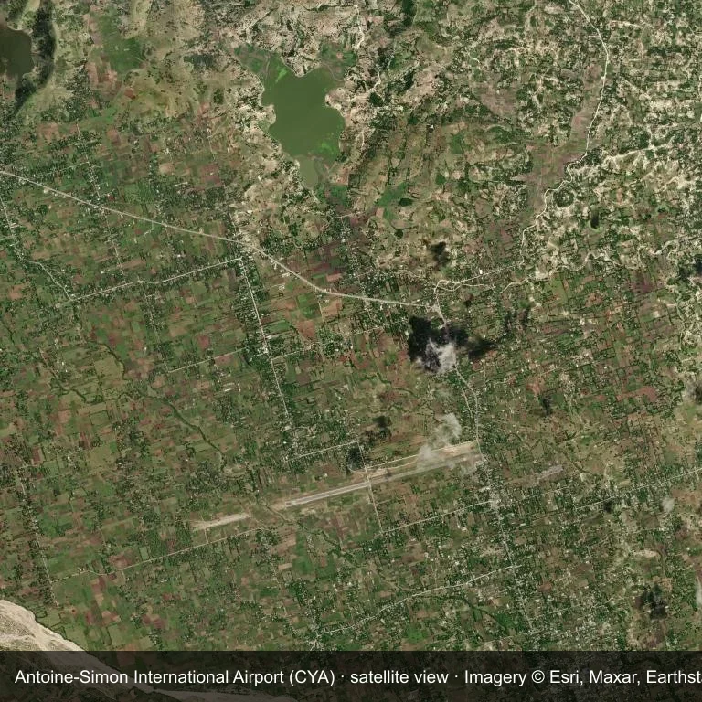
Satellite view of Antoine-Simon International Airport (CYA), with the airfield visible among a patchwork of vegetation and open ground.
Imagery: Esri World Imagery (© Esri, Maxar, Earthstar Geographics), with attribution in the image. It shows the field from orbit, not from the ground.
Airport at a glance
| Item | Detail |
|---|---|
| IATA / ICAO | CYA / MTCA |
| Role | medium-sized airport |
| Elevation | about 62 m |
| Coordinates | 18.2711, -73.7883 |
| Runways | 1, longest 981 m |
| Non-stop destinations | 0 in the 2014 snapshot |
Runways
| Runway | Length | Surface |
|---|---|---|
| 08/26 | 981 m | ASP |
Why there is no route table
The 2014 OpenFlights snapshot contains no scheduled services for CYA. Absence from that dataset is not proof that the field is unused today; check current airport and airline information before travelling.
Nearby airports
| Airport | Distance | Non-stop destinations |
|---|---|---|
| Jérémie Airport (JEE) | ~59.4 km | — |
| Toussaint Louverture International Airport (PAP) | ~161 km | 12 |
| Cap Haitien International Airport (CAP) | ~232 km | 2 |
Getting there and navigating
- Coordinates: 18.2711, -73.7883
- Open in a map: Google Maps | Amap | Baidu Maps
The location map on this page places the field in relation to nearby towns and roads. Terminal connections and local transport fall outside this dataset; the airport or airline can confirm them.
Airport sketch
Antoine-Simon International Airport occupies ground in Haiti surrounded by a patchwork of vegetation and open ground. The 08/26 runway runs east–west and offers 981 m of asphalt; elevation is about 62 m.
The runway gives 981 m of asphalt, a turboprop and light-jet profile. The paved surface supports regular operations, though it does not imply scheduled service. Jérémie Airport is 59.4 km away, with no recorded destinations in the same snapshot.
With no routes in the 2014 data, this is not a reliable scheduled destination. Use Jérémie Airport as the nearest back-up and verify access with the airport operator.
Before you fly
- The 981 m runway limits operations to small aircraft; baggage and payload limits are usually strict.
- The runway is paved, which supports year-round operations, but scheduled service is still not guaranteed.
- Jérémie Airport is the nearest airport in this dataset, 59.4 km away, but it also has no recorded destinations for 2014.
- The site has no terminal guide on this page, so allow extra time for local arrangements and onward transport.
- Treat this as a general-aviation or charter field rather than a large terminal; confirm handling and opening hours in advance.
About the data
Runways, elevation and coordinates come from OurAirports open data; routes come from the June 2014 OpenFlights snapshot. That snapshot describes network shape and scale, not current schedules.
Комментарии читателейОбсуждение
Вопросы, отчёты о поездках и исправления приветствуются. Комментарии видны всем.
Загрузка…
Загрузка комментариев…