
Albany International Airport
 Albany · สหรัฐอเมริกา· Albany International Airport
Albany International Airport (IATA: ALB, ICAO KALB) เป็นสนามบินขนาดใหญ่ที่ให้บริการAlbany, สหรัฐอเมริกา
Albany International Airport is a large airport, at an elevation of about 285 ft, with scheduled passenger service. This page gathers its location map, airport codes and travel information.
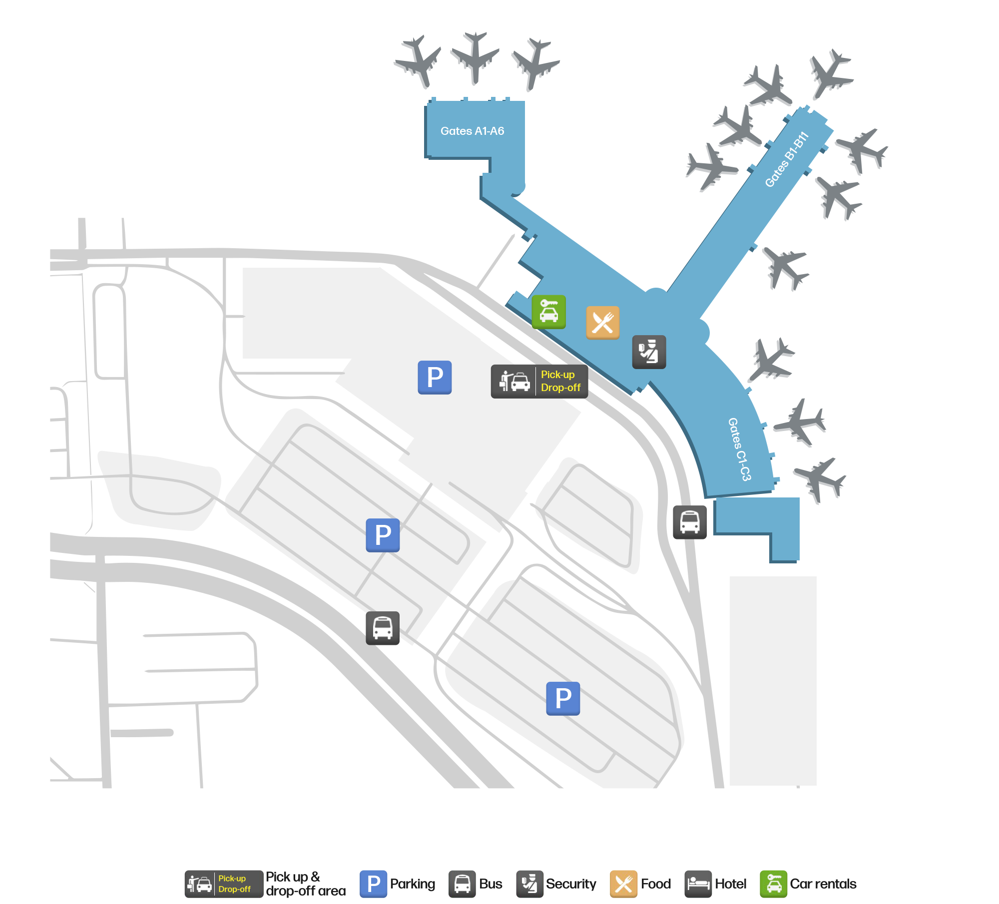
ดาวน์โหลดแผนที่สนามบินดาวน์โหลด
ภาพสนามบินภาพสนามบิน
ภาพจริงของสนามบินแห่งนี้ พร้อมเครดิตของหน้าเว็บสาธารณะที่พบภาพ; ลิขสิทธิ์ยังเป็นของผู้ถ่ายภาพต้นฉบับ คลิกที่ภาพเพื่อขยาย หรือคลิกบรรทัดเครดิตเพื่อเปิดหน้าแหล่งที่มา
ภาพถ่ายดาวเทียม: ทางวิ่งของออลบานีทอดเลียบขอบเมืองในหุบเขาฮัดสัน โดยมีอาคารผู้โดยสารและลานจอดอยู่ทางตะวันออกของสนามบิน
แผนที่เส้นทาง Albany International Airport — จุดหมายบินตรงแผนที่เส้นทาง
19 จุดหมายบินตรง: แผนที่ สายการบินที่ให้บริการ และระยะทาง
เที่ยวบินของAlbany International Airport — ขาออกและขาเข้าป้ายเที่ยวบิน
982 หมายเลขเที่ยวบิน ครอบคลุม 25 สายการบิน และ 26 จุดหมายปลายทาง แยกตามทิศทาง หมายเลขเที่ยวบินร่วม (codeshare) รวมอยู่ด้วย
| เที่ยวบิน | สายการบิน | จุดหมายปลายทาง | ประเทศ/ภูมิภาค |
|---|---|---|---|
| AA440 | American Airlines | Charlotte Douglas International Airport | สหรัฐอเมริกา |
| AA710 | American Airlines | Charlotte Douglas International Airport | สหรัฐอเมริกา |
| AA1050 | American Airlines | Charlotte Douglas International Airport | สหรัฐอเมริกา |
| AA1247 | American Airlines | Charlotte Douglas International Airport | สหรัฐอเมริกา |
| AA1857 | American Airlines | Charlotte Douglas International Airport | สหรัฐอเมริกา |
| AA2180 | American Airlines | Charlotte Douglas International Airport | สหรัฐอเมริกา |
| AA2394 | American Airlines | Charlotte Douglas International Airport | สหรัฐอเมริกา |
| AA2663 | American Airlines | Charlotte Douglas International Airport | สหรัฐอเมริกา |
| AA3480 | American Airlines | Ronald Reagan Washington National Airport | สหรัฐอเมริกา |
| AA3729 | American Airlines | ท่าอากาศยานนานาชาติโอแฮร์ | สหรัฐอเมริกา |
| AA3826 | American Airlines | ท่าอากาศยานนานาชาติโอแฮร์ | สหรัฐอเมริกา |
| AA3835 | American Airlines | ท่าอากาศยานนานาชาติโอแฮร์ | สหรัฐอเมริกา |
| AA4028 | American Airlines | ท่าอากาศยานนานาชาติไมแอมี | สหรัฐอเมริกา |
| AA4256 | American Airlines | ท่าอากาศยานนานาชาติโอแฮร์ | สหรัฐอเมริกา |
| AA4337 | American Airlines | Ronald Reagan Washington National Airport | สหรัฐอเมริกา |
| AA4340 | American Airlines | ท่าอากาศยานนานาชาติไมแอมี | สหรัฐอเมริกา |
| AA4341 | American Airlines | Ronald Reagan Washington National Airport | สหรัฐอเมริกา |
| AA4346 | American Airlines | Ronald Reagan Washington National Airport | สหรัฐอเมริกา |
| AA4362 | American Airlines | Ronald Reagan Washington National Airport | สหรัฐอเมริกา |
| AA4420 | American Airlines | Ronald Reagan Washington National Airport | สหรัฐอเมริกา |
หมายเลขเที่ยวบินและเส้นทางจากดัชนีเที่ยวบิน aviability.com (ข้อมูล ณ วันที่ 26 ตุลาคม 2569); รวมหมายเลขเที่ยวบินร่วมและไม่แสดงเวลาเดินทาง ที่มา: aviability.com ↗
ข้อมูลและรายละเอียดสนามบินรายละเอียดสนามบิน
แผนที่อินเทอร์แอกทีฟ — ตำแหน่ง Albany International Airportแผนที่อินเทอร์แอกทีฟ
ดูสนามบินนี้บนบริการแผนที่อื่น:
Albany Airport (ALB): Nineteen Domestic Routes in the Hudson Valleyคู่มือสนามบิน
On satellite imagery, Albany's runways run along the edge of the Hudson Valley towns, with the terminal and apron east of the field. The airport serves Albany, New York, at an elevation of about 87 m, with runways of 2,591 m and 2,195 m; the 2014 snapshot records 19 domestic destinations, from Newark at 231 km to Las Vegas at 3,591 km.
Satellite view
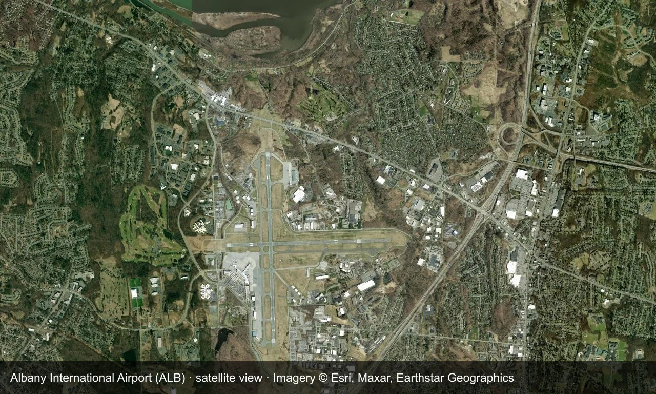
Satellite view: Albany's runways run along the edge of the Hudson Valley towns, with the terminal and apron east of the field.
The satellite image comes from Esri World Imagery (© Esri, Maxar, Earthstar Geographics); the field and attribution are labelled in the image. This is a satellite view, not a ground-level photograph.
Airport at a glance
| Item | Detail |
|---|---|
| IATA / ICAO | ALB / KALB |
| Role | Large airport |
| Elevation | about 87 m |
| Coordinates | 42.7483, -73.8017 |
| Runways | 2, longest 2,591 m |
| Non-stop destinations | 19 (2014 snapshot, all domestic US) |
| Official site | www.albanyairport.com |
Nearby airports
If nothing fits, these nearby fields are worth comparing:
| Airport | Distance |
|---|---|
| Adirondack Regional Airport (SLK) | 185 km |
| Westchester County Airport (HPN) | 187 km |
| LaGuardia Airport (LGA) | 219 km |
Before you fly
- Allow 90–120 minutes for a domestic departure; upstate New York winter weather can disrupt flights.
- The 19 destinations are a 2014 snapshot and Southwest and AirTran have consolidated routes; check current schedules.
About the data
Runways, elevation and coordinates come from OurAirports open data. Routes and carriers come from the June 2014 OpenFlights snapshot and include codeshares and interline services; they indicate network shape and scale, not current schedules.
ความคิดเห็นจากผู้อ่านการสนทนา
ยินดีรับคำถาม รายงานการเดินทาง และการแก้ไข ความคิดเห็นเป็นสาธารณะ
กำลังโหลด…
กำลังโหลดความคิดเห็น…