
Albany International Airport
 Albany · アメリカ合衆国· Albany International Airport
Albany International Airport(IATA: ALB、ICAO: KALB)はAlbany、アメリカ合衆国にある大型空港です。
Albany International Airport is a large airport, at an elevation of about 285 ft, with scheduled passenger service. This page gathers its location map, airport codes and travel information.
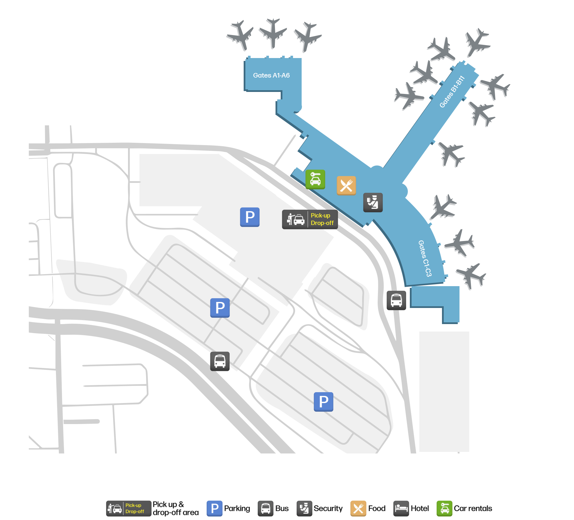
空港マップをダウンロードダウンロード
空港写真空港写真
この空港の実際の写真です。いずれも公開ウェブページを出典として明記しており、著作権は撮影者に帰属します。写真をクリックすると拡大表示され、クレジットをクリックすると元のページが開きます。
衛星画像:オールバニの滑走路はハドソン渓谷の町々の縁に沿って走り、ターミナルとエプロンは飛行場の東にある。
Albany International Airportの路線マップ — 直行便の目的地路線マップ
直行目的地19か所。地図、就航航空会社、距離を掲載しています。
Albany International Airport発着便 — 出発と到着フライトボード
便名982件、25社の航空会社、26か所の目的地を出発・到着別に掲載しています。コードシェア便も含みます。
| 便 | 航空会社 | 目的地 | 国・地域 |
|---|---|---|---|
| AA440 | American Airlines | Charlotte Douglas International Airport | アメリカ合衆国 |
| AA710 | American Airlines | Charlotte Douglas International Airport | アメリカ合衆国 |
| AA1050 | American Airlines | Charlotte Douglas International Airport | アメリカ合衆国 |
| AA1247 | American Airlines | Charlotte Douglas International Airport | アメリカ合衆国 |
| AA1857 | American Airlines | Charlotte Douglas International Airport | アメリカ合衆国 |
| AA2180 | American Airlines | Charlotte Douglas International Airport | アメリカ合衆国 |
| AA2394 | American Airlines | Charlotte Douglas International Airport | アメリカ合衆国 |
| AA2663 | American Airlines | Charlotte Douglas International Airport | アメリカ合衆国 |
| AA3480 | American Airlines | Ronald Reagan Washington National Airport | アメリカ合衆国 |
| AA3729 | American Airlines | オヘア国際空港 | アメリカ合衆国 |
| AA3826 | American Airlines | オヘア国際空港 | アメリカ合衆国 |
| AA3835 | American Airlines | オヘア国際空港 | アメリカ合衆国 |
| AA4028 | American Airlines | マイアミ国際空港 | アメリカ合衆国 |
| AA4256 | American Airlines | オヘア国際空港 | アメリカ合衆国 |
| AA4337 | American Airlines | Ronald Reagan Washington National Airport | アメリカ合衆国 |
| AA4340 | American Airlines | マイアミ国際空港 | アメリカ合衆国 |
| AA4341 | American Airlines | Ronald Reagan Washington National Airport | アメリカ合衆国 |
| AA4346 | American Airlines | Ronald Reagan Washington National Airport | アメリカ合衆国 |
| AA4362 | American Airlines | Ronald Reagan Washington National Airport | アメリカ合衆国 |
| AA4420 | American Airlines | Ronald Reagan Washington National Airport | アメリカ合衆国 |
便名と路線はaviability.comのフライトインデックス(スナップショット:2026年10月26日)に基づきます。コードシェア便を含み、出発時刻は掲載していません。出典:aviability.com ↗
空港情報と詳細空港の詳細
インタラクティブマップ — Albany International Airportの位置インタラクティブマップ
他の地図サービスでこの空港を見る:
Albany Airport (ALB): Nineteen Domestic Routes in the Hudson Valley空港ガイド
On satellite imagery, Albany's runways run along the edge of the Hudson Valley towns, with the terminal and apron east of the field. The airport serves Albany, New York, at an elevation of about 87 m, with runways of 2,591 m and 2,195 m; the 2014 snapshot records 19 domestic destinations, from Newark at 231 km to Las Vegas at 3,591 km.
Satellite view
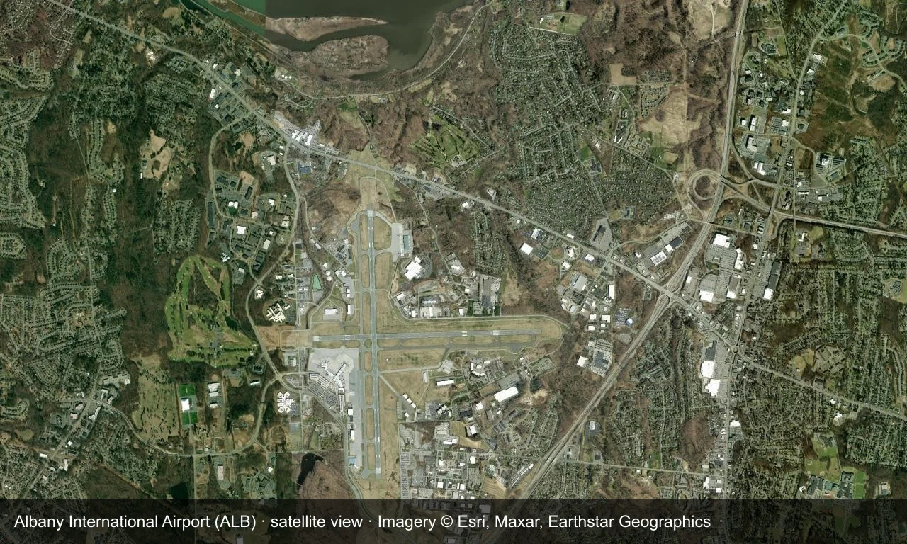
Satellite view: Albany's runways run along the edge of the Hudson Valley towns, with the terminal and apron east of the field.
The satellite image comes from Esri World Imagery (© Esri, Maxar, Earthstar Geographics); the field and attribution are labelled in the image. This is a satellite view, not a ground-level photograph.
Airport at a glance
| Item | Detail |
|---|---|
| IATA / ICAO | ALB / KALB |
| Role | Large airport |
| Elevation | about 87 m |
| Coordinates | 42.7483, -73.8017 |
| Runways | 2, longest 2,591 m |
| Non-stop destinations | 19 (2014 snapshot, all domestic US) |
| Official site | www.albanyairport.com |
Nearby airports
If nothing fits, these nearby fields are worth comparing:
| Airport | Distance |
|---|---|
| Adirondack Regional Airport (SLK) | 185 km |
| Westchester County Airport (HPN) | 187 km |
| LaGuardia Airport (LGA) | 219 km |
Before you fly
- Allow 90–120 minutes for a domestic departure; upstate New York winter weather can disrupt flights.
- The 19 destinations are a 2014 snapshot and Southwest and AirTran have consolidated routes; check current schedules.
About the data
Runways, elevation and coordinates come from OurAirports open data. Routes and carriers come from the June 2014 OpenFlights snapshot and include codeshares and interline services; they indicate network shape and scale, not current schedules.
読者コメントディスカッション
質問、旅行記、訂正など、お気軽にお寄せください。コメントは公開されます。
読み込み中…
コメントを読み込み中…