
Da Nang International Airport
 Da Nang · Vietnam· Da Nang International Airport
Da Nang International Airport (IATA: DAD, OACI VVDN) es un aeropuerto mediano que da servicio a Da Nang, Vietnam.
Da Nang International Airport (DAD) is a medium airport serving Da Nang, Vietnam. This page gathers the airport codes, location map and travel information.
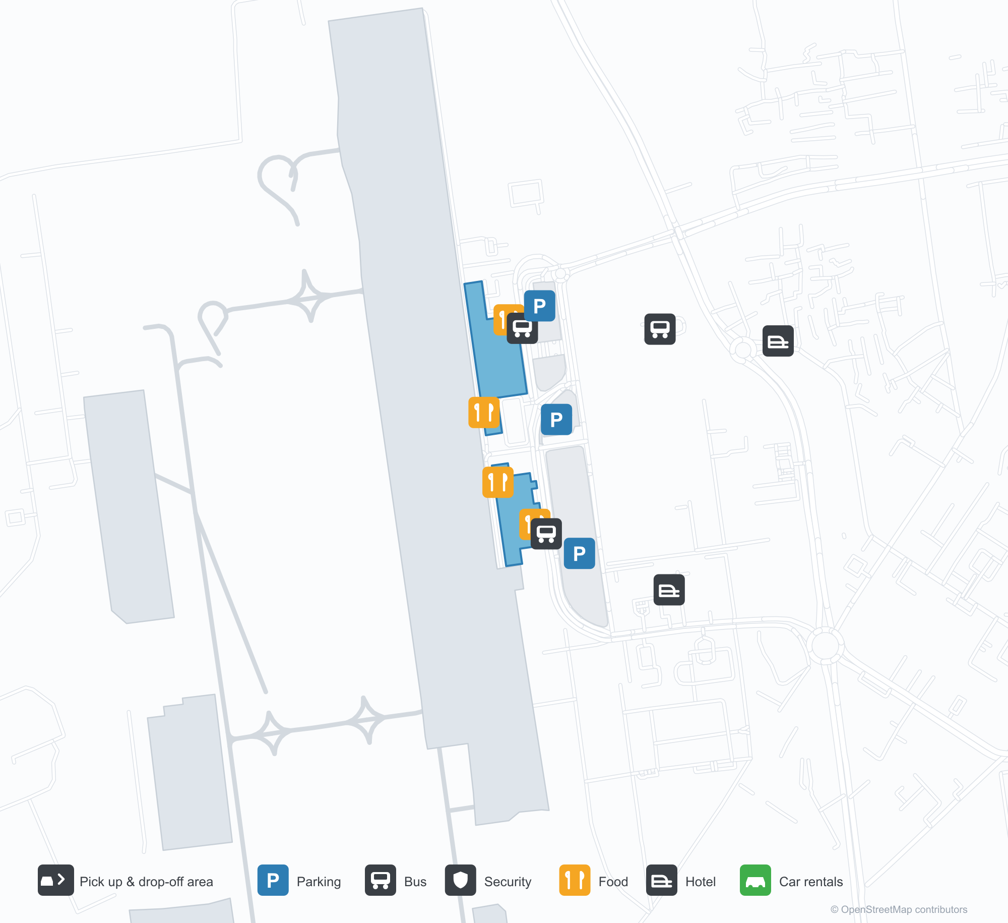
Descargar mapas de aeropuertosDescargas
Fotos del aeropuertoFotos del aeropuerto
Fotos reales de este aeropuerto, cada una con la referencia de la página web pública donde se encontró; los derechos de autor siguen siendo de los fotógrafos originales. Haz clic en una foto para ampliarla o en la línea de crédito para abrir su página de origen.
La vía de descenso de pasajeros frente a la terminal del aeropuerto de Da Nang, flanqueada por una hilera de marquesinas blancas curvas.
Dentro de la terminal del aeropuerto de Da Nang, un cartel luminoso de «Welcome to Da Nang» se alza sobre un muro vegetal.
En la imagen satelital se aprecia claramente la disposición del Aeropuerto Internacional de Da Nang (DAD) y su entorno.
Mapa de rutas de Da Nang International Airport — destinos directosMapa de rutas
19 destinos directos: mapa, aerolíneas que operan y distancias.
Vuelos de Da Nang International Airport — salidas y llegadasPanel de vuelos
936 números de vuelo de 64 aerolíneas y 27 destinos, divididos por dirección. Se incluyen los números de código compartido.
| Vuelo | Aerolínea | Destino | País/región |
|---|---|---|---|
| 5J5757 | Cebu Pacific | Aeropuerto Internacional Ninoy Aquino | Filipinas |
| 5J5759 | Cebu Pacific | Aeropuerto Internacional Ninoy Aquino | Filipinas |
| 7C2212 | Jeju Air | Aeropuerto Internacional de Incheon | Corea del Sur |
| 7C2218 | Jeju Air | Aeropuerto Internacional de Incheon | Corea del Sur |
| 8M455 | Myanmar Airways International | Yangón (RGN) Yangon International Airport | Myanmar |
| 9G908 | Sun Phuquoc Airways | Noi Bai International Airport | Vietnam |
| 9G910 | Sun Phuquoc Airways | Noi Bai International Airport | Vietnam |
| 9G922 | Sun Phuquoc Airways | Noi Bai International Airport | Vietnam |
| 9G924 | Sun Phuquoc Airways | Noi Bai International Airport | Vietnam |
| 9G928 | Sun Phuquoc Airways | Noi Bai International Airport | Vietnam |
| 9G930 | Sun Phuquoc Airways | Noi Bai International Airport | Vietnam |
| 9G932 | Sun Phuquoc Airways | Noi Bai International Airport | Vietnam |
| 9G934 | Sun Phuquoc Airways | Noi Bai International Airport | Vietnam |
| 9G936 | Sun Phuquoc Airways | Noi Bai International Airport | Vietnam |
| 9G940 | Sun Phuquoc Airways | Noi Bai International Airport | Vietnam |
| 9G946 | Sun Phuquoc Airways | Noi Bai International Airport | Vietnam |
| 9G961 | Sun Phuquoc Airways | Aeropuerto Internacional de Tan Son Nhat | Vietnam |
| 9G965 | Sun Phuquoc Airways | Aeropuerto Internacional de Tan Son Nhat | Vietnam |
| 9G967 | Sun Phuquoc Airways | Aeropuerto Internacional de Tan Son Nhat | Vietnam |
| 9G971 | Sun Phuquoc Airways | Aeropuerto Internacional de Tan Son Nhat | Vietnam |
Números de vuelo y rutas del índice de vuelos de aviability.com (instantánea de 26 de octubre de 2026); se incluyen los números de código compartido y no se muestran horarios de salida. Fuente: aviability.com ↗
Información y datos del aeropuertoDatos del aeropuerto
Mapa interactivo — ubicación de Da Nang International AirportMapa interactivo
Consulta este aeropuerto en otros servicios de mapas:
Da Nang International Airport GuideGuía del aeropuerto
Da Nang International Airport (IATA DAD, ICAO VVDN) serves Da Nang, Vietnam, Southeast Asia, and is classified as a medium-sized airport. This page gathers what the site's database, maps and route dataset say about it in one place.
Airport photos
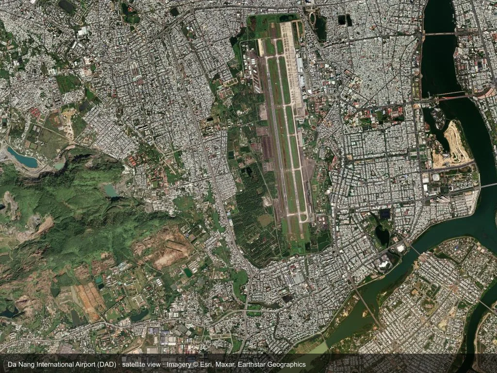
In the satellite image, the layout of Da Nang International Airport (DAD) and its surroundings are clearly visible.

The drop-off roadway outside Da Nang airport's terminal, lined with a row of curved white canopies.

Inside Da Nang airport's terminal, a glowing 'Welcome to Da Nang' sign stands above a planted wall.
The photos come from public web sources and remain the copyright of their photographers; full credits and source links sit in the photo gallery on this page.
Facts at a glance
| IATA / ICAO | DAD / VVDN |
| Airport class | medium-sized airport |
| Location | Da Nang, Vietnam (Southeast Asia) |
| Coordinates | 16.0439, 108.1990 |
| Direct destinations | 19 (see below) |
Airport map
The map on this page is rendered from OpenStreetMap data: airports with terminal polygons show the terminal buildings, aprons and access roads, while small fields show the airfield outline and runway. Icons for parking, buses, food, hotels and car rentals follow whatever OSM has mapped.
- Full-size view — open the map card on this page to zoom in; the 2000 px original can be downloaded.
- Location map — the interactive map lets you pan and zoom to see the field against the city and road network.
- Schematic — the page also draws a size-based schematic to indicate the airport's scale; it is not the actual layout.
Direct routes
Non-stop destinations, nearest first (OpenFlights route dataset, compiled 2014 — treat as indicative and confirm with the airline):
| Destination | Distance | Main carriers |
|---|---|---|
| Pleiku Airport (PXU) | ~228 km | Vietnam Airlines |
| Buon Ma Thuot Airport (BMV) | ~375 km | Vietnam Airlines |
| Vinh Airport (VII) | ~402 km | Vietnam Airlines |
| Cam Ranh International Airport / Cam Ranh Air Base (CXR) | ~463 km | Vietnam Airlines |
| Lien Khuong Airport (DLI) | ~478 km | Vietnam Airlines |
| Cat Bi International Airport (HPH) | ~553 km | Vietnam Airlines |
| Tan Son Nhat International Airport (SGN) | ~605 km | Jetstar Pacific, Royal Air Cambodge |
| Noi Bai International Airport (HAN) | ~628 km | Jetstar Pacific, Royal Air Cambodge |
See the Da Nang International Airport route map for the full list of 19 non-stop destinations.
Nearby airports
If nothing fits, these nearby fields are worth comparing:
| Airport | Distance |
|---|---|
| Sanya Phoenix International Airport (SYX) | 282 km |
| Haikou Meilan International Airport (HAK) | 494 km |
| Tan Son Nhat International Airport (SGN) | 605 km |
Getting there
The airport: coordinates 16.0439, 108.1990; elevation about 10 m.
Navigate straight to the field:
- Driving / taxi: 高德地图 | 百度地图 | Google Maps
The location map on this page shows the field against the city and road network, and the ground-transport section lists the public transport recorded for it. For driving routes, timetables and parking, rely on the airport's own information.
Size and facilities
Medium-sized airports are regional hubs: one compact terminal, walkable distances and usually faster check-in than a major hub — but with fewer frequencies, so rebooking after a missed flight is harder. Aim for 90–120 minutes before departure.
Terminal plans, check-in locations and ground-transport timetables are published by the airport itself; for detail that must be right on the day, rely on the airport's own information. If something here looks wrong, please tell us via the Contact page and we will check it.
Tips
- If your destination is not in the table above, you will usually connect via Pleiku Airport (PXU) or another larger airport.
- Use the search box at the top of the page to compare alternatives: type a city name or IATA code.
- In peak season parking and rental cars run short at small fields too — book ahead if you are driving.
Comentarios de los lectoresDebate
Las preguntas, los relatos de viaje y las correcciones son bienvenidos. Los comentarios son públicos.
Cargando…
Cargando comentarios…