
Asheville Regional Airport
 Asheville · Estados Unidos· Asheville Regional Airport
Asheville Regional Airport (IATA: AVL, OACI KAVL) es un aeropuerto mediano que da servicio a Asheville, Estados Unidos.
Asheville Regional Airport is a medium-sized airport, at an elevation of about 2,165 ft, with scheduled passenger service. This page gathers its location map, airport codes and travel information.
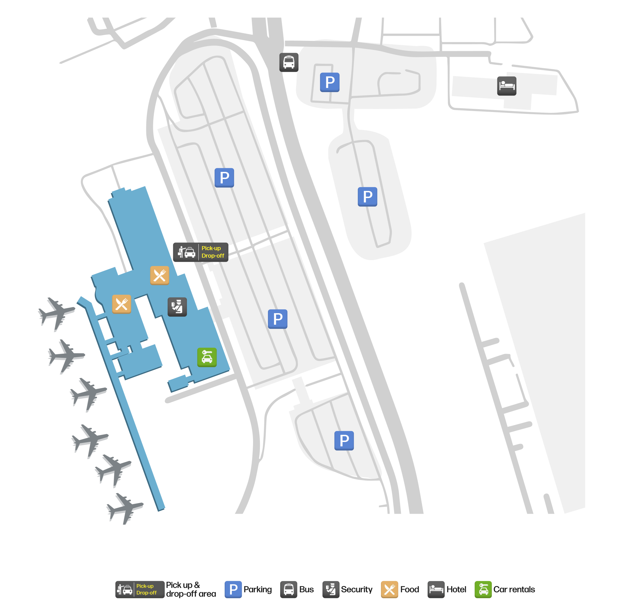
Descargar mapas de aeropuertosDescargas
Fotos del aeropuertoFotos del aeropuerto
Fotos reales de este aeropuerto, cada una con la referencia de la página web pública donde se encontró; los derechos de autor siguen siendo de los fotógrafos originales. Haz clic en una foto para ampliarla o en la línea de crédito para abrir su página de origen.
El letrero de entrada del Aeropuerto Regional de Asheville: letras verdes junto a un panel SHUTTLE LOT, con colinas boscosas al fondo.
Mapa de rutas de Asheville Regional Airport — destinos directosMapa de rutas
8 destinos directos: mapa, aerolíneas que operan y distancias.
Vuelos de Asheville Regional Airport — salidas y llegadasPanel de vuelos
1389 números de vuelo de 19 aerolíneas y 23 destinos, divididos por dirección. Se incluyen los números de código compartido.
| Vuelo | Aerolínea | Destino | País/región |
|---|---|---|---|
| AA569 | American Airlines | Dallas Fort Worth International Airport | Estados Unidos |
| AA629 | American Airlines | Ronald Reagan Washington National Airport | Estados Unidos |
| AA1077 | American Airlines | Ronald Reagan Washington National Airport | Estados Unidos |
| AA1937 | American Airlines | Dallas Fort Worth International Airport | Estados Unidos |
| AA2106 | American Airlines | Dallas Fort Worth International Airport | Estados Unidos |
| AA2400 | American Airlines | Dallas Fort Worth International Airport | Estados Unidos |
| AA2718 | American Airlines | Dallas Fort Worth International Airport | Estados Unidos |
| AA3073 | American Airlines | Dallas Fort Worth International Airport | Estados Unidos |
| AA3356 | American Airlines | Aeropuerto Internacional de Miami | Estados Unidos |
| AA3424 | American Airlines | Aeropuerto Internacional O'Hare | Estados Unidos |
| AA3528 | American Airlines | Aeropuerto Internacional O'Hare | Estados Unidos |
| AA3535 | American Airlines | Aeropuerto Internacional O'Hare | Estados Unidos |
| AA3549 | American Airlines | Aeropuerto Internacional O'Hare | Estados Unidos |
| AA3560 | American Airlines | Aeropuerto Internacional de Miami | Estados Unidos |
| AA3571 | American Airlines | Aeropuerto Internacional O'Hare | Estados Unidos |
| AA3623 | American Airlines | Aeropuerto Internacional O'Hare | Estados Unidos |
| AA3650 | American Airlines | Aeropuerto Internacional de Miami | Estados Unidos |
| AA3678 | American Airlines | Dallas Fort Worth International Airport | Estados Unidos |
| AA3702 | American Airlines | Aeropuerto Internacional de Miami | Estados Unidos |
| AA3782 | American Airlines | Aeropuerto Internacional de Miami | Estados Unidos |
Números de vuelo y rutas del índice de vuelos de aviability.com (instantánea de 26 de octubre de 2026); se incluyen los números de código compartido y no se muestran horarios de salida. Fuente: aviability.com ↗
Información y datos del aeropuertoDatos del aeropuerto
Mapa interactivo — ubicación de Asheville Regional AirportMapa interactivo
Consulta este aeropuerto en otros servicios de mapas:
Asheville Airport (AVL): A Mountain Gateway With Eight Domestic RoutesGuía del aeropuerto
The photo of Asheville Regional Airport (IATA AVL, ICAO KAVL) is of the entrance: a green "Asheville Regional Airport" sign beside a SHUTTLE LOT display, with trees and hills behind. For a regional airport serving a mountain city in western North Carolina, that image is more distinctive than a terminal façade — it tells you where the airport is before it tells you where it flies.
The field sits in Asheville, North Carolina, at an elevation of about 660 m, with a single 2,439 m runway (17/35). The 2014 route snapshot records 8 non-stop destinations, all in the United States.
Airport photos

The entrance sign at Asheville Regional Airport — green lettering beside a SHUTTLE LOT display, with wooded hills behind.
The photos come from public web sources and remain the copyright of their photographers; full credits and source links sit in the photo gallery on this page.
Airport at a glance
| Item | Detail |
|---|---|
| IATA / ICAO | AVL / KAVL |
| Role | Medium-sized airport and regional gateway for western North Carolina |
| Elevation | about 660 m |
| Coordinates | 35.4355, -82.5419 |
| Runway | 1: 17/35, 2,439 m × 46 m asphalt |
| Non-stop destinations | 8 (2014 snapshot, all domestic US) |
| Official site | flyavl.com |
Network shape: seven short hops and one longer link
By distance: 7 destinations within 1,000 km, 1 between 1,000 and 3,000 km, and none beyond 3,000 km. The nearest are Charlotte (147 km) and Atlanta (264 km), the two hubs that carry most connections; farther out are Orlando Sanford (751 km) and Detroit (757 km). Chicago O'Hare (863 km) and Punta Gorda (948 km) are still inside 1,000 km; the only route beyond that is Fort Lauderdale at 1,066 km.
| Distance band | Destinations |
|---|---|
| Under 1,000 km | 7 |
| 1,000–3,000 km | 1 |
| Over 3,000 km | 0 |
Allegiant Air appears on 4 routes, Delta Air Lines on 2, and American Airlines and US Airways on 1 each. The carrier column includes codeshares, so the figures describe concentration. The full list is on the Asheville route map.
Getting there and navigating
- Coordinates: 35.4355, -82.5419
- Official site: flyavl.com
- Open in a map: Google Maps | Amap | Baidu Maps
If fares are close, compare Anderson Regional (AND, about 106 km) and Athens Ben Epps (AHN, about 180 km); neither has comparable scheduled-route data, so Charlotte and Atlanta remain the practical alternatives.
The location map on this page shows the field against Asheville and the Blue Ridge road network. For terminal connections and local transport, check the airport's or airline's own information.
Before you fly
- The 8 destinations are a 2014 snapshot. Allegiant's leisure routes are seasonal, so check the airline's current schedule.
- The airport is small, so 90–120 minutes before departure is usually enough. Mountain weather can disrupt flights, especially in winter, so leave a buffer.
- The SHUTTLE LOT display in the photo points to a shuttle parking area; if you are driving, confirm the lot and shuttle location before working backwards from your flight time.
About the data
Runways, elevation and coordinates come from OurAirports open data. Routes and carriers come from the June 2014 OpenFlights snapshot and include codeshares and interline services; they indicate network shape and scale, not current schedules. Photos are from public web sources and remain the copyright of their photographers.
History
Owned by the City of Asheville and set in the town of Fletcher 14 km south of the city, the field passed 580,000 passengers in 2009 (+4.1%) on a single 2,439 m runway, with general aviation and air taxis making up most movements.
Source: Asheville Rgnl Airport.
Comentarios de los lectoresDebate
Las preguntas, los relatos de viaje y las correcciones son bienvenidos. Los comentarios son públicos.
Cargando…
Cargando comentarios…