
Asheville Regional Airport
 Asheville · สหรัฐอเมริกา· Asheville Regional Airport
Asheville Regional Airport (IATA: AVL, ICAO KAVL) เป็นสนามบินขนาดกลางที่ให้บริการAsheville, สหรัฐอเมริกา
Asheville Regional Airport is a medium-sized airport, at an elevation of about 2,165 ft, with scheduled passenger service. This page gathers its location map, airport codes and travel information.
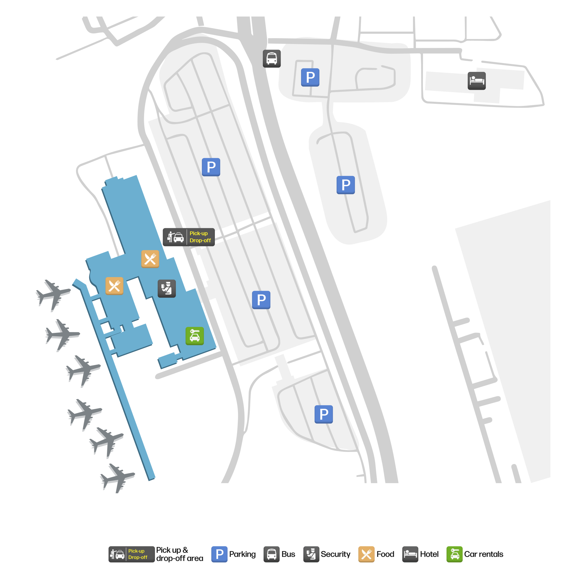
ดาวน์โหลดแผนที่สนามบินดาวน์โหลด
ภาพสนามบินภาพสนามบิน
ภาพจริงของสนามบินแห่งนี้ พร้อมเครดิตของหน้าเว็บสาธารณะที่พบภาพ; ลิขสิทธิ์ยังเป็นของผู้ถ่ายภาพต้นฉบับ คลิกที่ภาพเพื่อขยาย หรือคลิกบรรทัดเครดิตเพื่อเปิดหน้าแหล่งที่มา
ป้ายทางเข้าท่าอากาศยานภูมิภาคแอชวิลล์ — ตัวอักษรสีเขียวข้างจอแสดง 'SHUTTLE LOT' โดยมีเนินเขาที่เต็มไปด้วยป่าอยู่ด้านหลัง
แผนที่เส้นทาง Asheville Regional Airport — จุดหมายบินตรงแผนที่เส้นทาง
8 จุดหมายบินตรง: แผนที่ สายการบินที่ให้บริการ และระยะทาง
เที่ยวบินของAsheville Regional Airport — ขาออกและขาเข้าป้ายเที่ยวบิน
1,389 หมายเลขเที่ยวบิน ครอบคลุม 19 สายการบิน และ 23 จุดหมายปลายทาง แยกตามทิศทาง หมายเลขเที่ยวบินร่วม (codeshare) รวมอยู่ด้วย
| เที่ยวบิน | สายการบิน | จุดหมายปลายทาง | ประเทศ/ภูมิภาค |
|---|---|---|---|
| AA569 | American Airlines | Dallas Fort Worth International Airport | สหรัฐอเมริกา |
| AA629 | American Airlines | Ronald Reagan Washington National Airport | สหรัฐอเมริกา |
| AA1077 | American Airlines | Ronald Reagan Washington National Airport | สหรัฐอเมริกา |
| AA1937 | American Airlines | Dallas Fort Worth International Airport | สหรัฐอเมริกา |
| AA2106 | American Airlines | Dallas Fort Worth International Airport | สหรัฐอเมริกา |
| AA2400 | American Airlines | Dallas Fort Worth International Airport | สหรัฐอเมริกา |
| AA2718 | American Airlines | Dallas Fort Worth International Airport | สหรัฐอเมริกา |
| AA3073 | American Airlines | Dallas Fort Worth International Airport | สหรัฐอเมริกา |
| AA3356 | American Airlines | ท่าอากาศยานนานาชาติไมแอมี | สหรัฐอเมริกา |
| AA3424 | American Airlines | ท่าอากาศยานนานาชาติโอแฮร์ | สหรัฐอเมริกา |
| AA3528 | American Airlines | ท่าอากาศยานนานาชาติโอแฮร์ | สหรัฐอเมริกา |
| AA3535 | American Airlines | ท่าอากาศยานนานาชาติโอแฮร์ | สหรัฐอเมริกา |
| AA3549 | American Airlines | ท่าอากาศยานนานาชาติโอแฮร์ | สหรัฐอเมริกา |
| AA3560 | American Airlines | ท่าอากาศยานนานาชาติไมแอมี | สหรัฐอเมริกา |
| AA3571 | American Airlines | ท่าอากาศยานนานาชาติโอแฮร์ | สหรัฐอเมริกา |
| AA3623 | American Airlines | ท่าอากาศยานนานาชาติโอแฮร์ | สหรัฐอเมริกา |
| AA3650 | American Airlines | ท่าอากาศยานนานาชาติไมแอมี | สหรัฐอเมริกา |
| AA3678 | American Airlines | Dallas Fort Worth International Airport | สหรัฐอเมริกา |
| AA3702 | American Airlines | ท่าอากาศยานนานาชาติไมแอมี | สหรัฐอเมริกา |
| AA3782 | American Airlines | ท่าอากาศยานนานาชาติไมแอมี | สหรัฐอเมริกา |
หมายเลขเที่ยวบินและเส้นทางจากดัชนีเที่ยวบิน aviability.com (ข้อมูล ณ วันที่ 26 ตุลาคม 2569); รวมหมายเลขเที่ยวบินร่วมและไม่แสดงเวลาเดินทาง ที่มา: aviability.com ↗
ข้อมูลและรายละเอียดสนามบินรายละเอียดสนามบิน
แผนที่อินเทอร์แอกทีฟ — ตำแหน่ง Asheville Regional Airportแผนที่อินเทอร์แอกทีฟ
ดูสนามบินนี้บนบริการแผนที่อื่น:
Asheville Airport (AVL): A Mountain Gateway With Eight Domestic Routesคู่มือสนามบิน
The photo of Asheville Regional Airport (IATA AVL, ICAO KAVL) is of the entrance: a green "Asheville Regional Airport" sign beside a SHUTTLE LOT display, with trees and hills behind. For a regional airport serving a mountain city in western North Carolina, that image is more distinctive than a terminal façade — it tells you where the airport is before it tells you where it flies.
The field sits in Asheville, North Carolina, at an elevation of about 660 m, with a single 2,439 m runway (17/35). The 2014 route snapshot records 8 non-stop destinations, all in the United States.
Airport photos

The entrance sign at Asheville Regional Airport — green lettering beside a SHUTTLE LOT display, with wooded hills behind.
The photos come from public web sources and remain the copyright of their photographers; full credits and source links sit in the photo gallery on this page.
Airport at a glance
| Item | Detail |
|---|---|
| IATA / ICAO | AVL / KAVL |
| Role | Medium-sized airport and regional gateway for western North Carolina |
| Elevation | about 660 m |
| Coordinates | 35.4355, -82.5419 |
| Runway | 1: 17/35, 2,439 m × 46 m asphalt |
| Non-stop destinations | 8 (2014 snapshot, all domestic US) |
| Official site | flyavl.com |
Network shape: seven short hops and one longer link
By distance: 7 destinations within 1,000 km, 1 between 1,000 and 3,000 km, and none beyond 3,000 km. The nearest are Charlotte (147 km) and Atlanta (264 km), the two hubs that carry most connections; farther out are Orlando Sanford (751 km) and Detroit (757 km). Chicago O'Hare (863 km) and Punta Gorda (948 km) are still inside 1,000 km; the only route beyond that is Fort Lauderdale at 1,066 km.
| Distance band | Destinations |
|---|---|
| Under 1,000 km | 7 |
| 1,000–3,000 km | 1 |
| Over 3,000 km | 0 |
Allegiant Air appears on 4 routes, Delta Air Lines on 2, and American Airlines and US Airways on 1 each. The carrier column includes codeshares, so the figures describe concentration. The full list is on the Asheville route map.
Getting there and navigating
- Coordinates: 35.4355, -82.5419
- Official site: flyavl.com
- Open in a map: Google Maps | Amap | Baidu Maps
If fares are close, compare Anderson Regional (AND, about 106 km) and Athens Ben Epps (AHN, about 180 km); neither has comparable scheduled-route data, so Charlotte and Atlanta remain the practical alternatives.
The location map on this page shows the field against Asheville and the Blue Ridge road network. For terminal connections and local transport, check the airport's or airline's own information.
Before you fly
- The 8 destinations are a 2014 snapshot. Allegiant's leisure routes are seasonal, so check the airline's current schedule.
- The airport is small, so 90–120 minutes before departure is usually enough. Mountain weather can disrupt flights, especially in winter, so leave a buffer.
- The SHUTTLE LOT display in the photo points to a shuttle parking area; if you are driving, confirm the lot and shuttle location before working backwards from your flight time.
About the data
Runways, elevation and coordinates come from OurAirports open data. Routes and carriers come from the June 2014 OpenFlights snapshot and include codeshares and interline services; they indicate network shape and scale, not current schedules. Photos are from public web sources and remain the copyright of their photographers.
History
Owned by the City of Asheville and set in the town of Fletcher 14 km south of the city, the field passed 580,000 passengers in 2009 (+4.1%) on a single 2,439 m runway, with general aviation and air taxis making up most movements.
Source: Asheville Rgnl Airport.
ความคิดเห็นจากผู้อ่านการสนทนา
ยินดีรับคำถาม รายงานการเดินทาง และการแก้ไข ความคิดเห็นเป็นสาธารณะ
กำลังโหลด…
กำลังโหลดความคิดเห็น…