
Asheville Regional Airport
 Asheville · アメリカ合衆国· Asheville Regional Airport
Asheville Regional Airport(IATA: AVL、ICAO: KAVL)はAsheville、アメリカ合衆国にある中型空港です。
Asheville Regional Airport is a medium-sized airport, at an elevation of about 2,165 ft, with scheduled passenger service. This page gathers its location map, airport codes and travel information.
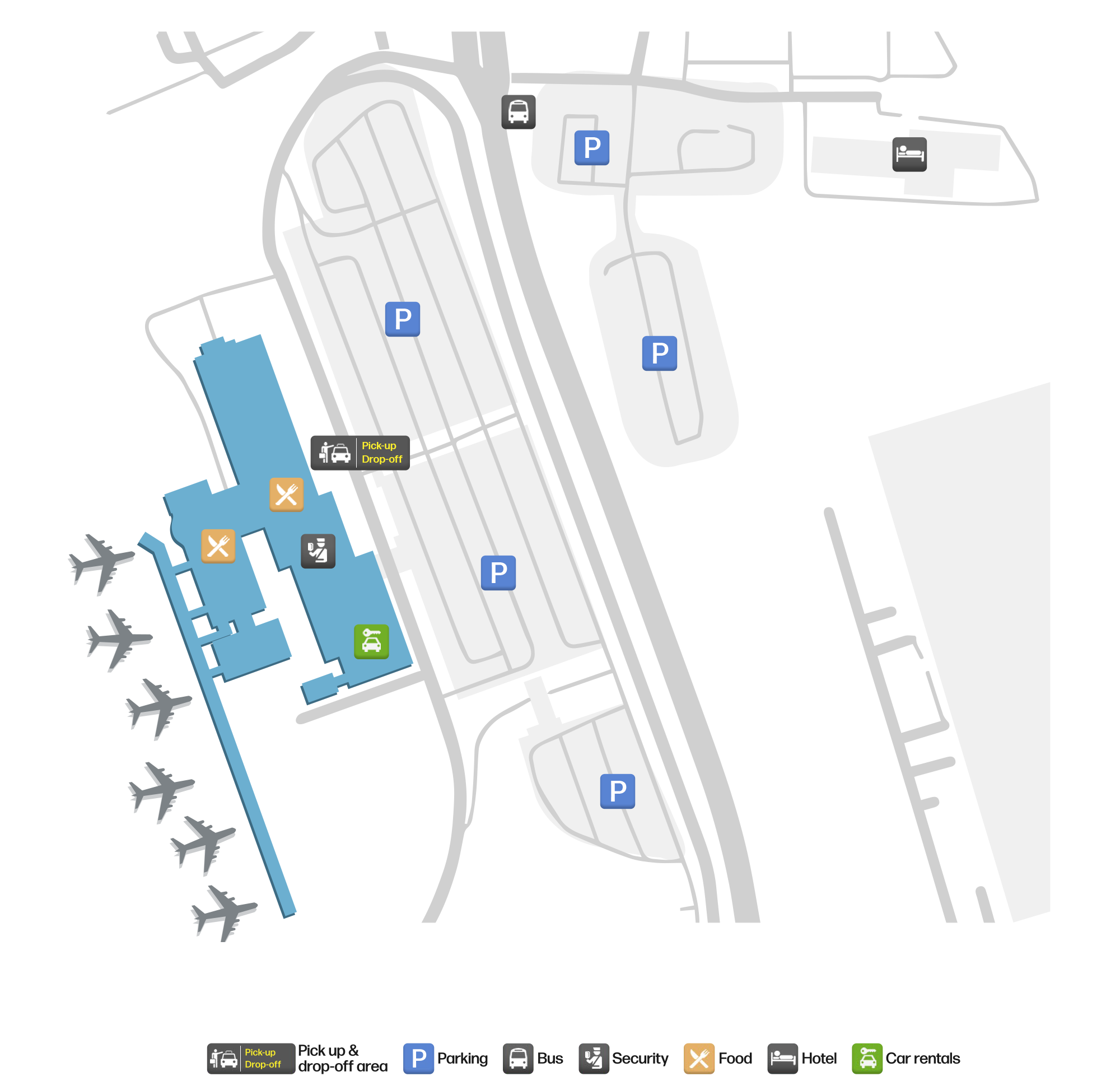
空港マップをダウンロードダウンロード
空港写真空港写真
この空港の実際の写真です。いずれも公開ウェブページを出典として明記しており、著作権は撮影者に帰属します。写真をクリックすると拡大表示され、クレジットをクリックすると元のページが開きます。
アッシュビル地域空港の入口看板——緑の文字のそばにSHUTTLE LOTの表示、背後に森の丘陵。
Asheville Regional Airportの路線マップ — 直行便の目的地路線マップ
直行目的地8か所。地図、就航航空会社、距離を掲載しています。
Asheville Regional Airport発着便 — 出発と到着フライトボード
便名1,389件、19社の航空会社、23か所の目的地を出発・到着別に掲載しています。コードシェア便も含みます。
| 便 | 航空会社 | 目的地 | 国・地域 |
|---|---|---|---|
| AA569 | American Airlines | Dallas Fort Worth International Airport | アメリカ合衆国 |
| AA629 | American Airlines | Ronald Reagan Washington National Airport | アメリカ合衆国 |
| AA1077 | American Airlines | Ronald Reagan Washington National Airport | アメリカ合衆国 |
| AA1937 | American Airlines | Dallas Fort Worth International Airport | アメリカ合衆国 |
| AA2106 | American Airlines | Dallas Fort Worth International Airport | アメリカ合衆国 |
| AA2400 | American Airlines | Dallas Fort Worth International Airport | アメリカ合衆国 |
| AA2718 | American Airlines | Dallas Fort Worth International Airport | アメリカ合衆国 |
| AA3073 | American Airlines | Dallas Fort Worth International Airport | アメリカ合衆国 |
| AA3356 | American Airlines | マイアミ国際空港 | アメリカ合衆国 |
| AA3424 | American Airlines | オヘア国際空港 | アメリカ合衆国 |
| AA3528 | American Airlines | オヘア国際空港 | アメリカ合衆国 |
| AA3535 | American Airlines | オヘア国際空港 | アメリカ合衆国 |
| AA3549 | American Airlines | オヘア国際空港 | アメリカ合衆国 |
| AA3560 | American Airlines | マイアミ国際空港 | アメリカ合衆国 |
| AA3571 | American Airlines | オヘア国際空港 | アメリカ合衆国 |
| AA3623 | American Airlines | オヘア国際空港 | アメリカ合衆国 |
| AA3650 | American Airlines | マイアミ国際空港 | アメリカ合衆国 |
| AA3678 | American Airlines | Dallas Fort Worth International Airport | アメリカ合衆国 |
| AA3702 | American Airlines | マイアミ国際空港 | アメリカ合衆国 |
| AA3782 | American Airlines | マイアミ国際空港 | アメリカ合衆国 |
便名と路線はaviability.comのフライトインデックス(スナップショット:2026年10月26日)に基づきます。コードシェア便を含み、出発時刻は掲載していません。出典:aviability.com ↗
空港情報と詳細空港の詳細
インタラクティブマップ — Asheville Regional Airportの位置インタラクティブマップ
他の地図サービスでこの空港を見る:
Asheville Airport (AVL): A Mountain Gateway With Eight Domestic Routes空港ガイド
The photo of Asheville Regional Airport (IATA AVL, ICAO KAVL) is of the entrance: a green "Asheville Regional Airport" sign beside a SHUTTLE LOT display, with trees and hills behind. For a regional airport serving a mountain city in western North Carolina, that image is more distinctive than a terminal façade — it tells you where the airport is before it tells you where it flies.
The field sits in Asheville, North Carolina, at an elevation of about 660 m, with a single 2,439 m runway (17/35). The 2014 route snapshot records 8 non-stop destinations, all in the United States.
Airport photos

The entrance sign at Asheville Regional Airport — green lettering beside a SHUTTLE LOT display, with wooded hills behind.
The photos come from public web sources and remain the copyright of their photographers; full credits and source links sit in the photo gallery on this page.
Airport at a glance
| Item | Detail |
|---|---|
| IATA / ICAO | AVL / KAVL |
| Role | Medium-sized airport and regional gateway for western North Carolina |
| Elevation | about 660 m |
| Coordinates | 35.4355, -82.5419 |
| Runway | 1: 17/35, 2,439 m × 46 m asphalt |
| Non-stop destinations | 8 (2014 snapshot, all domestic US) |
| Official site | flyavl.com |
Network shape: seven short hops and one longer link
By distance: 7 destinations within 1,000 km, 1 between 1,000 and 3,000 km, and none beyond 3,000 km. The nearest are Charlotte (147 km) and Atlanta (264 km), the two hubs that carry most connections; farther out are Orlando Sanford (751 km) and Detroit (757 km). Chicago O'Hare (863 km) and Punta Gorda (948 km) are still inside 1,000 km; the only route beyond that is Fort Lauderdale at 1,066 km.
| Distance band | Destinations |
|---|---|
| Under 1,000 km | 7 |
| 1,000–3,000 km | 1 |
| Over 3,000 km | 0 |
Allegiant Air appears on 4 routes, Delta Air Lines on 2, and American Airlines and US Airways on 1 each. The carrier column includes codeshares, so the figures describe concentration. The full list is on the Asheville route map.
Getting there and navigating
- Coordinates: 35.4355, -82.5419
- Official site: flyavl.com
- Open in a map: Google Maps | Amap | Baidu Maps
If fares are close, compare Anderson Regional (AND, about 106 km) and Athens Ben Epps (AHN, about 180 km); neither has comparable scheduled-route data, so Charlotte and Atlanta remain the practical alternatives.
The location map on this page shows the field against Asheville and the Blue Ridge road network. For terminal connections and local transport, check the airport's or airline's own information.
Before you fly
- The 8 destinations are a 2014 snapshot. Allegiant's leisure routes are seasonal, so check the airline's current schedule.
- The airport is small, so 90–120 minutes before departure is usually enough. Mountain weather can disrupt flights, especially in winter, so leave a buffer.
- The SHUTTLE LOT display in the photo points to a shuttle parking area; if you are driving, confirm the lot and shuttle location before working backwards from your flight time.
About the data
Runways, elevation and coordinates come from OurAirports open data. Routes and carriers come from the June 2014 OpenFlights snapshot and include codeshares and interline services; they indicate network shape and scale, not current schedules. Photos are from public web sources and remain the copyright of their photographers.
History
Owned by the City of Asheville and set in the town of Fletcher 14 km south of the city, the field passed 580,000 passengers in 2009 (+4.1%) on a single 2,439 m runway, with general aviation and air taxis making up most movements.
Source: Asheville Rgnl Airport.
読者コメントディスカッション
質問、旅行記、訂正など、お気軽にお寄せください。コメントは公開されます。
読み込み中…
コメントを読み込み中…