
Annette Island Airport
 Annette Island · ABD· Annette Island Airport
Annette Island Airport (IATA: ANN, ICAO PANT), Annette Island, ABD kentine hizmet veren bir orta büyüklükte havalimanıdır.
Annette Island Airport is a medium-sized airport, at an elevation of about 119 ft. This page gathers its location map, airport codes and travel information.

Havalimanı Haritalarını İndirinİndirmeler
Havalimanı fotoğraflarıHavalimanı Fotoğrafları
Bu havalimanının gerçek fotoğrafları; her fotoğrafın altında, fotoğrafın bulunduğu kamuya açık web sayfasına bir atıf yer alır ve telif hakkı özgün fotoğrafçılarda kalır. Yakınlaştırmak için bir fotoğrafa, kaynak sayfasını açmak için bir atıf satırına tıklayın.
Uydu görüntüsünde Annette Island Havalimanı'nın (ANN) pisti yeşil bitki örtüsü ve tarım arazileri arasında yer alıyor.
Bu siyah-beyaz hava görüntüsünde apron ve taksi yolu yer yer çimenlerin arasında birleşiyor; kenar boyunca uzun bir hangar ve birkaç alçak bina var.
Bu havalimanı diyagramı, 07/25 ve 02/20 olarak adlandırılmış kesişen iki pisti gösteriyor; uzunlukları ve saha yükseltisi belirtilmiş.
Kokpitten bir uçuş simülatörü görünümü, pervane kanatlarının üzerinden düz karlı arazideki bir piste bakıyor; ötede dağlar ve deniz var.
Eski bir siyah-beyaz karede tel örgü çitin yanındaki bir tabela havalimanının Ketchikan ve çevresine hizmet ettiğini söylüyor; solda bir Pan Am kuyruğu görünüyor.
Uçak işaretli bir konum haritası, havaalanını Ketchikan'ın güneyindeki bir adaya yerleştiriyor; haritada Hydaburg ve Prince Rupert da adlandırılmış.
Havalimanı bilgileri ve ayrıntılarıHavalimanı Ayrıntıları
Etkileşimli harita — Annette Island Airport konumuEtkileşimli Harita
Bu havalimanını diğer harita hizmetlerinde görüntüleyin:
Annette Island Airport (ANN) Guide: A regional runway in contextHavalimanı Rehberi
Satellite imagery of Annette Island Airport (ANN) in the United States shows a field surrounded by green vegetation and farmland. At about 36 m above sea level, it has 2 runways, the longest 2,284 m. The 2014 snapshot lists no scheduled destinations; Ketchikan International Airport is 36.5 km away.
Satellite view
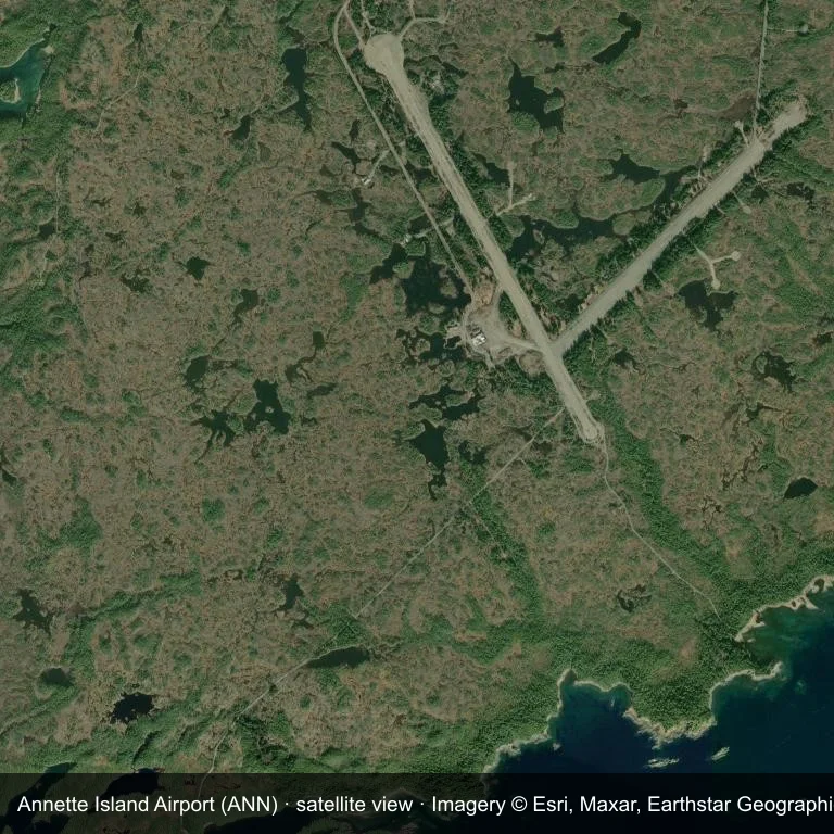
Satellite view of Annette Island Airport (ANN), with the airfield visible among green vegetation and farmland.
Imagery: Esri World Imagery (© Esri, Maxar, Earthstar Geographics), with attribution in the image. It shows the field from orbit, not from the ground.
Airport at a glance
| Item | Detail |
|---|---|
| IATA / ICAO | ANN / PANT |
| Role | medium-sized airport |
| Elevation | about 36 m |
| Coordinates | 55.0377, -131.5726 |
| Runways | 2, longest 2,284 m |
| Non-stop destinations | 0 in the 2014 snapshot |
Runways
| Runway | Length | Surface |
|---|---|---|
| 12/30 | 2,284 m | ASP |
| 02/20 | 1,740 m | GVL |
Why there is no route table
The 2014 OpenFlights snapshot contains no scheduled services for ANN. Absence from that dataset is not proof that the field is unused today; check current airport and airline information before travelling.
Nearby airports
| Airport | Distance | Non-stop destinations |
|---|---|---|
| Ketchikan International Airport (KTN) | ~36.5 km | 5 |
| Prince Rupert Airport (YPR) | ~111 km | 1 |
| Klawock Airport (KLW) | ~113 km | 1 |
Getting there and navigating
- Coordinates: 55.0377, -131.5726
- Open in a map: Google Maps | Amap | Baidu Maps
The location map on this page places the field in relation to nearby towns and roads. Terminal connections and local transport fall outside this dataset; the airport or airline can confirm them.
Airport sketch
Annette Island Airport occupies ground in the United States surrounded by green vegetation and farmland. The 12/30 runway runs northwest–southeast and offers 2,284 m of asphalt; elevation is about 36 m.
The runway gives 2,284 m of asphalt, a regional-jet profile. The paved surface supports regular operations, though it does not imply scheduled service. Ketchikan International Airport is 36.5 km away, with 5 destinations in the same snapshot.
With no routes in the 2014 data, this is not a reliable scheduled destination. Use Ketchikan International Airport as the nearest back-up and verify access with the airport operator.
Before you fly
- The 2,284 m runway can take larger regional aircraft, but that does not guarantee scheduled service.
- The runway is paved, which supports year-round operations, but scheduled service is still not guaranteed.
- Ketchikan International Airport is 36.5 km away with 5 destinations in the 2014 snapshot, making it the nearest alternative for a scheduled flight.
- The site has no terminal guide on this page, so allow extra time for local arrangements and onward transport.
- Treat this as a general-aviation or charter field rather than a large terminal; confirm handling and opening hours in advance.
About the data
Runways, elevation and coordinates come from OurAirports open data; routes come from the June 2014 OpenFlights snapshot. That snapshot describes network shape and scale, not current schedules.
Okuyucu yorumlarıTartışma
Sorular, seyahat deneyimleri ve düzeltmeler memnuniyetle karşılanır. Yorumlar herkese açıktır.
Yükleniyor…
Yorumlar yükleniyor…