
Annette Island Airport
 Annette Island · Estados Unidos· Annette Island Airport
O Annette Island Airport (IATA: ANN, ICAO PANT) é um aeroporto de porte médio que atende Annette Island, Estados Unidos.
Annette Island Airport is a medium-sized airport, at an elevation of about 119 ft. This page gathers its location map, airport codes and travel information.

Baixar mapas do aeroportoDownloads
Fotos do aeroportoFotos do aeroporto
Fotos reais deste aeroporto, cada uma creditada à página pública da web onde foi encontrada; os direitos autorais continuam com os fotógrafos originais. Clique em uma foto para ampliar ou em uma linha de crédito para abrir a página de origem.
Na imagem de satélite, a pista do Aeroporto da Ilha Annette (ANN) fica entre vegetação verde e terras agrícolas.
Nesta vista aérea em preto e branco, o pátio e a pista de táxi se encontram entre grama irregular, com um longo hangar e alguns edifícios baixos ao longo da borda.
Este diagrama aeroportuário mostra duas pistas que se cruzam, identificadas como 07/25 e 02/20, com seus comprimentos e a elevação do campo indicados.
Uma vista de simulador de voo a partir da cabine olha sobre as pás da hélice para uma pista em uma região plana e nevada, com montanhas e mar ao fundo.
Em uma antiga foto em preto e branco, uma placa junto à cerca de tela diz que o aeroporto atende Ketchikan e arredores, com a cauda de um Pan Am visível à esquerda.
Um mapa de localização com um marcador de avião posiciona o aeródromo em uma ilha ao sul de Ketchikan, e a carta também nomeia Hydaburg e Prince Rupert.
Informações e detalhes do aeroportoDetalhes do aeroporto
Mapa interativo — localização do Annette Island AirportMapa interativo
Veja este aeroporto em outros serviços de mapas:
Annette Island Airport (ANN) Guide: A regional runway in contextGuia do aeroporto
Satellite imagery of Annette Island Airport (ANN) in the United States shows a field surrounded by green vegetation and farmland. At about 36 m above sea level, it has 2 runways, the longest 2,284 m. The 2014 snapshot lists no scheduled destinations; Ketchikan International Airport is 36.5 km away.
Satellite view
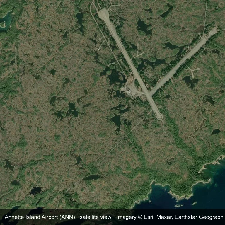
Satellite view of Annette Island Airport (ANN), with the airfield visible among green vegetation and farmland.
Imagery: Esri World Imagery (© Esri, Maxar, Earthstar Geographics), with attribution in the image. It shows the field from orbit, not from the ground.
Airport at a glance
| Item | Detail |
|---|---|
| IATA / ICAO | ANN / PANT |
| Role | medium-sized airport |
| Elevation | about 36 m |
| Coordinates | 55.0377, -131.5726 |
| Runways | 2, longest 2,284 m |
| Non-stop destinations | 0 in the 2014 snapshot |
Runways
| Runway | Length | Surface |
|---|---|---|
| 12/30 | 2,284 m | ASP |
| 02/20 | 1,740 m | GVL |
Why there is no route table
The 2014 OpenFlights snapshot contains no scheduled services for ANN. Absence from that dataset is not proof that the field is unused today; check current airport and airline information before travelling.
Nearby airports
| Airport | Distance | Non-stop destinations |
|---|---|---|
| Ketchikan International Airport (KTN) | ~36.5 km | 5 |
| Prince Rupert Airport (YPR) | ~111 km | 1 |
| Klawock Airport (KLW) | ~113 km | 1 |
Getting there and navigating
- Coordinates: 55.0377, -131.5726
- Open in a map: Google Maps | Amap | Baidu Maps
The location map on this page places the field in relation to nearby towns and roads. Terminal connections and local transport fall outside this dataset; the airport or airline can confirm them.
Airport sketch
Annette Island Airport occupies ground in the United States surrounded by green vegetation and farmland. The 12/30 runway runs northwest–southeast and offers 2,284 m of asphalt; elevation is about 36 m.
The runway gives 2,284 m of asphalt, a regional-jet profile. The paved surface supports regular operations, though it does not imply scheduled service. Ketchikan International Airport is 36.5 km away, with 5 destinations in the same snapshot.
With no routes in the 2014 data, this is not a reliable scheduled destination. Use Ketchikan International Airport as the nearest back-up and verify access with the airport operator.
Before you fly
- The 2,284 m runway can take larger regional aircraft, but that does not guarantee scheduled service.
- The runway is paved, which supports year-round operations, but scheduled service is still not guaranteed.
- Ketchikan International Airport is 36.5 km away with 5 destinations in the 2014 snapshot, making it the nearest alternative for a scheduled flight.
- The site has no terminal guide on this page, so allow extra time for local arrangements and onward transport.
- Treat this as a general-aviation or charter field rather than a large terminal; confirm handling and opening hours in advance.
About the data
Runways, elevation and coordinates come from OurAirports open data; routes come from the June 2014 OpenFlights snapshot. That snapshot describes network shape and scale, not current schedules.
Comentários dos leitoresDiscussão
Perguntas, relatos de viagem e correções são bem-vindos. Os comentários são públicos.
Carregando…
Carregando comentários…