
Almaty International Airport
 อัลมาตี · คาซัคสถาน· Almaty International Airport
Almaty International Airport (IATA: ALA, ICAO UAAA) เป็นสนามบินขนาดใหญ่ที่ให้บริการอัลมาตี, คาซัคสถาน
Almaty International Airport is a large airport, at an elevation of about 2,234 ft, with scheduled passenger service. This page gathers its location map, airport codes and travel information.
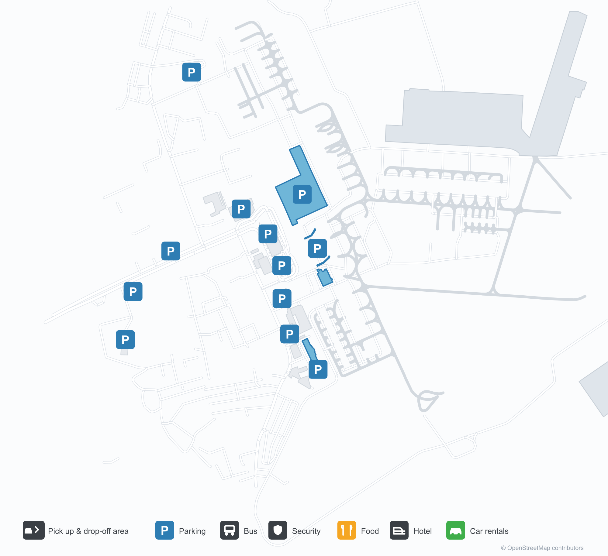
ดาวน์โหลดแผนที่สนามบินดาวน์โหลด
ภาพสนามบินภาพสนามบิน
ภาพจริงของสนามบินแห่งนี้ พร้อมเครดิตของหน้าเว็บสาธารณะที่พบภาพ; ลิขสิทธิ์ยังเป็นของผู้ถ่ายภาพต้นฉบับ คลิกที่ภาพเพื่อขยาย หรือคลิกบรรทัดเครดิตเพื่อเปิดหน้าแหล่งที่มา
อาคารผู้โดยสารอัลมาตีในยามกลางวัน — เส้นหลังคาโค้งไหลลื่นพร้อมทางลาดที่นำรถขึ้นไปยังขาออก
ยามค่ำคืน ป้ายนีออนสีแดง 'АЭРОПОРТ АЛМАТЫ' เรืองแสงเหนือด้านหน้ากระจก
ทิวทัศน์ฤดูหนาวหน้าอาคารผู้โดยสาร — แท็กซี่และรถมินิบัสในหิมะใต้ยอดแหลมเพชรของหลังคา
ตัวอักษร ALA โดดเด่นบนด้านหน้ากระจกของอาคารผู้โดยสารอัลมาตี โดยมีชื่อสนามบินภาษาคาซัคและอังกฤษอยู่ด้านล่าง
มองจากอากาศ สนามหญ้ากว้างกั้นทางวิ่งของอัลมาตีจากทางขับ ขณะที่เครื่องบินโดยสารเต็มลานจอดข้างอาคารผู้โดยสารหลังคาสีฟ้า
เครื่องบินโดยสารสีขาวหลายลำจอดบนลานจอด ลำหนึ่งหางสีเขียว และมีภูเขายอดหิมะตั้งตระหง่านอยู่เบื้องหลังในอากาศใส
เครื่องบินเจ็ตสีฟ้าขาวรออยู่บนลานจอดภายใต้ท้องฟ้ามืดครึ้ม โดยมีสายพานสัมภาระที่ทำเครื่องหมาย ALA จอดอยู่ข้าง ๆ
ใต้ยอดเขาหิมะ หลังคามีข้อความ ALMATY AIRPORT พร้อมเครื่องบินเจ็ตสีขาวบนลานจอดและหอบังคับการบินทางซ้าย
ภาพถ่ายทางอากาศยามกลางวันนี้ หลังคาสีฟ้าอ่อนของอาคารผู้โดยสารเชื่อมต่อกัน เครื่องบินโดยสารจอดเต็มช่องจอด และมีไซต์ก่อสร้างอยู่ข้าง ๆ
ภาพถ่ายดาวเทียมของสนามบินอัลมาตี — ทางวิ่งยาวหนึ่งเส้นตัดเฉียงผ่านลานจอดและทางขับ โดยมีที่อยู่อาศัยหนาแน่นอยู่อีกฟาก
แผนที่เส้นทาง Almaty International Airport — จุดหมายบินตรงแผนที่เส้นทาง
42 จุดหมายบินตรง: แผนที่ สายการบินที่ให้บริการ และระยะทาง
เที่ยวบินของAlmaty International Airport — ขาออกและขาเข้าป้ายเที่ยวบิน
652 หมายเลขเที่ยวบิน ครอบคลุม 58 สายการบิน และ 82 จุดหมายปลายทาง แยกตามทิศทาง หมายเลขเที่ยวบินร่วม (codeshare) รวมอยู่ด้วย
| เที่ยวบิน | สายการบิน | จุดหมายปลายทาง | ประเทศ/ภูมิภาค |
|---|---|---|---|
| 3F788 | Flyone Armenia | เยเรวาน (EVN) Zvartnots International Airport | อาร์เมเนีย |
| 3F3788 | Flyone Armenia | เยเรวาน (EVN) Zvartnots International Airport | อาร์เมเนีย |
| 3L782 | Air Arabia Abu Dhabi | Zayed International Airport | สหรัฐอาหรับเอมิเรตส์ |
| 4J216 | United Caribbean Airlines | ดูชานเบ (DYU) Dushanbe International Airport | ทาจิกิสถาน |
| A15007 | Apg Airlines | Václav Havel Airport Prague | สาธารณรัฐเช็ก |
| A15008 | Apg Airlines | Noi Bai International Airport | เวียดนาม |
| A46142 | Azimuth | Mineralnyye Vody (MRV) Mineralnye Vody Airport | รัสเซีย |
| AI6802 | Air India | ท่าอากาศยานนานาชาติอินทิรา คานธี | อินเดีย |
| AI6804 | Air India | ท่าอากาศยานนานาชาติอินทิรา คานธี | อินเดีย |
| AI6806 | Air India | Chhatrapati Shivaji Maharaj International Airport | อินเดีย |
| AI6810 | Air India | ท่าอากาศยานนานาชาติอินทิรา คานธี | อินเดีย |
| AT5785 | Royal Air Maroc | ท่าอากาศยานนานาชาติฮามัด | กาตาร์ |
| AT5787 | Royal Air Maroc | ท่าอากาศยานนานาชาติฮามัด | กาตาร์ |
| B2768 | Belavia | มินสก์ (MSQ) Minsk National Airport | เบลารุส |
| BA6378 | British Airways | ท่าอากาศยานนานาชาติฮามัด | กาตาร์ |
| C6206 | My Freighter | ท่าอากาศยานนานาชาติอิสลาม คาริมอฟ ทาชเคนต์ | อุซเบกิสถาน |
| CA456 | Air China | Chengdu Tianfu International Airport | จีน |
| CA800 | Air China | ท่าอากาศยานนานาชาติปักกิ่ง | จีน |
| CX680 | Cathay Pacific | ท่าอากาศยานนานาชาติฮ่องกง | จีน |
| CX6221 | Cathay Pacific | ท่าอากาศยานนานาชาติอินทิรา คานธี | อินเดีย |
หมายเลขเที่ยวบินและเส้นทางจากดัชนีเที่ยวบิน aviability.com (ข้อมูล ณ วันที่ 26 ตุลาคม 2569); รวมหมายเลขเที่ยวบินร่วมและไม่แสดงเวลาเดินทาง ที่มา: aviability.com ↗
ข้อมูลและรายละเอียดสนามบินรายละเอียดสนามบิน
แผนที่อินเทอร์แอกทีฟ — ตำแหน่ง Almaty International Airportแผนที่อินเทอร์แอกทีฟ
ดูสนามบินนี้บนบริการแผนที่อื่น:
Almaty Airport (ALA): A Central Asian Hub in Winterคู่มือสนามบิน
Three photographs tell the Almaty story from different angles. By day, a flowing roofline carries traffic up to the departures level. At night, red neon spelling "АЭРОПОРТ АЛМАТЫ" glows above the glazed frontage, with the roof's diamond finial picked out in light. The third image is the same forecourt under snow, taxis and minibuses waiting in the cold. Together they describe a Central Asian hub that has to keep working through winter.
Almaty International Airport (IATA ALA, ICAO UAAA) serves Almaty, Kazakhstan, at an elevation of about 681 m. Its two runways measure 4,500 m and 4,400 m. The 2014 route snapshot records 42 non-stop destinations: 14 in Kazakhstan and 28 abroad.
Airport photos
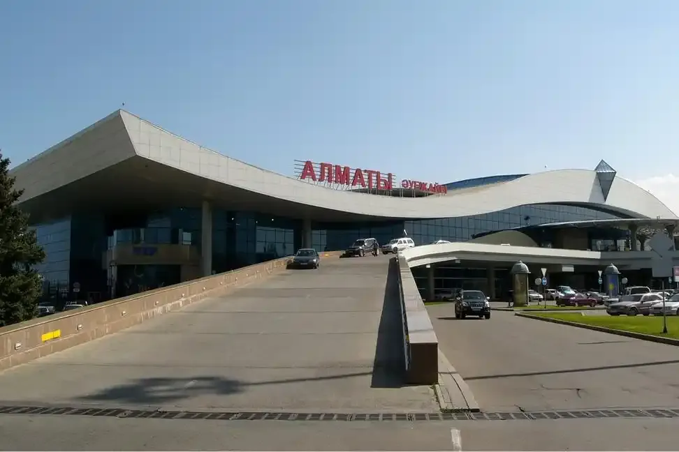
Almaty's terminal by day — the flowing roofline with its ramp carrying traffic up to departures.
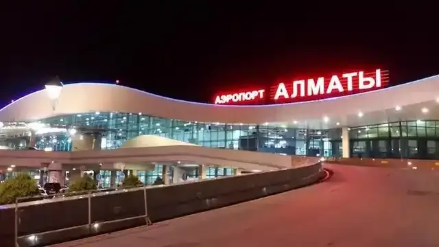
At night the red neon 'АЭРОПОРТ АЛМАТЫ' glows above the glazed frontage.
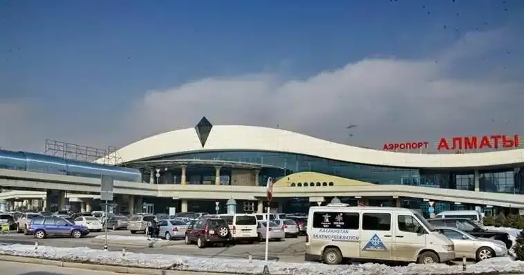
A winter view in front of the terminal — taxis and minibuses in the snow beneath the roof's diamond finial.
The photos come from public web sources and remain the copyright of their photographers; full credits and source links sit in the photo gallery on this page.
Airport at a glance
| Item | Detail |
|---|---|
| IATA / ICAO | ALA / UAAA |
| Role | Large airport and regional hub for Central Asia |
| Elevation | about 681 m |
| Coordinates | 43.3543, 77.0428 |
| Runways | 2: 05L/23R at 4,500 m, 05R/23L at 4,400 m |
| Non-stop destinations | 42 (14 domestic, 28 international; 2014 snapshot) |
Network shape: 28 international routes, the longest to London
By distance: 11 destinations within 1,000 km, 15 between 1,000 and 3,000 km, 16 between 3,000 and 6,000 km, and none beyond 6,000 km. The near layer is Taraz (469 km), Shymkent (626 km) and Tashkent (679 km). The far layer reaches London Heathrow (5,624 km), Amsterdam (5,256 km) and Kuala Lumpur (5,131 km). In this snapshot every route is under 5,700 km, making ALA a regional hub focused on the CIS, the Middle East, Europe and Southeast Asia rather than a transoceanic gateway.
| Distance band | Destinations |
|---|---|
| Under 1,000 km | 11 |
| 1,000–3,000 km | 15 |
| 3,000–6,000 km | 16 |
| Over 6,000 km | 0 |
Air Astana appears on 27 of the 42 routes and Scat Air on 11. The carrier column includes codeshares, so the figures describe concentration rather than who operates every flight. The full list is on the Almaty route map.
Getting there and navigating
- Coordinates: 43.3543, 77.0428
- Open in a map: Google Maps | Amap | Baidu Maps
If fares are close, the nearest large-airport comparison in the snapshot is Tashkent (TAS): about 679 km away with 52 non-stop destinations. Tashkent is also one of ALA's own destinations, which makes a short connection between the two cities practical.
The location map on this page shows the field against Almaty and the surrounding road network. This page does not cover terminal connections or local transport; confirm them with the airport or airline.
Before you fly
- Allow 2–3 hours for an international departure. The snow in the photos is not decorative: de-icing and runway clearing can push early flights into a longer queue.
- The two 4,400 m-plus runways can take long-haul widebodies, but none of the 42 destinations in the 2014 snapshot is beyond 6,000 km. Do not treat ALA as an intercontinental long-haul hub on that data alone.
- The 42 destinations are a 2014 snapshot; Air Astana and Scat have expanded since. Check current schedules before booking.
About the data
Runways, elevation and coordinates come from OurAirports open data. Routes and carriers come from the June 2014 OpenFlights snapshot and include codeshares and interline services; they indicate network shape and scale, not current schedules. Photos are from public web sources and remain the copyright of their photographers.
History
Opened in 1935, the field became Alma-Ata Airport in 1991 and today's joint-stock Almaty International in 1994. The Tu-144's first scheduled freight run — Moscow to Alma-Ata — landed here in December 1975; passenger service began in November 1977, and the supersonic airliner's final scheduled flight was on this route on 1 June 1978. A 1998 runway rebuild brought CAT II capability and international status.
Source: Almaty Airport.
ความคิดเห็นจากผู้อ่านการสนทนา
ยินดีรับคำถาม รายงานการเดินทาง และการแก้ไข ความคิดเห็นเป็นสาธารณะ
กำลังโหลด…
กำลังโหลดความคิดเห็น…