
Atlantic City International Airport
 Atlantic City · アメリカ合衆国· Atlantic City International Airport
Atlantic City International Airport(IATA: ACY、ICAO: KACY)はAtlantic City、アメリカ合衆国にある中型空港です。
Atlantic City International Airport is a medium-sized airport, at an elevation of about 75 ft, with scheduled passenger service. This page gathers its location map, airport codes and travel information.
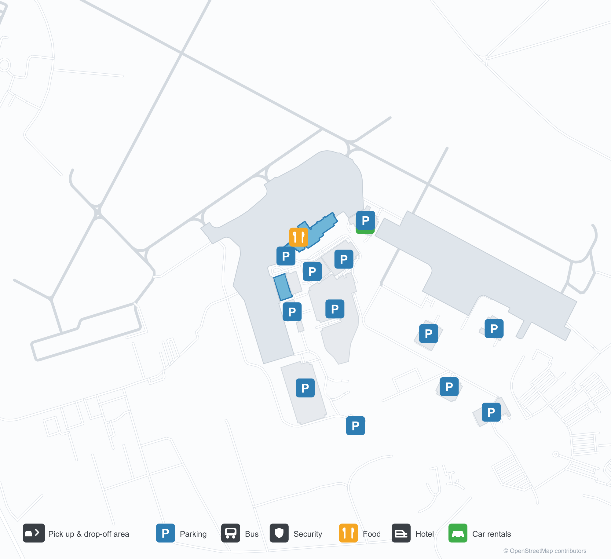
空港マップをダウンロードダウンロード
空港写真空港写真
この空港の実際の写真です。いずれも公開ウェブページを出典として明記しており、著作権は撮影者に帰属します。写真をクリックすると拡大表示され、クレジットをクリックすると元のページが開きます。
ターミナルの陸側の正面——銀色のパネルと大きなガラス張り、右側に「ATLANTIC CITY INTERNATIONAL AIRPORT」の文字。
空港入口の「A」モニュメント:青い文字が芝生の小さな航空機のシルエットを貫き、その奥にターミナルが続く。
アトランティックシティ国際空港の空撮:中央にターミナルとコンコース、周囲に駐車場と誘導路、地平線には市街のスカイラインが浮かぶ。
Atlantic City International Airportの路線マップ — 直行便の目的地路線マップ
直行目的地9か所。地図、就航航空会社、距離を掲載しています。
Atlantic City International Airport発着便 — 出発と到着フライトボード
便名160件、2社の航空会社、12か所の目的地を出発・到着別に掲載しています。コードシェア便も含みます。
| 便 | 航空会社 | 目的地 | 国・地域 |
|---|---|---|---|
| G4234 | Allegiant Air | オーランド (SFB) Orlando Sanford International Airport | アメリカ合衆国 |
| G4245 | Allegiant Air | オーランド (SFB) Orlando Sanford International Airport | アメリカ合衆国 |
| G4255 | Allegiant Air | オーランド (SFB) Orlando Sanford International Airport | アメリカ合衆国 |
| G4263 | Allegiant Air | オーランド (SFB) Orlando Sanford International Airport | アメリカ合衆国 |
| G4482 | Allegiant Air | Fort Lauderdale Hollywood International Airport | アメリカ合衆国 |
| G4487 | Allegiant Air | Fort Lauderdale Hollywood International Airport | アメリカ合衆国 |
| G4488 | Allegiant Air | Fort Lauderdale Hollywood International Airport | アメリカ合衆国 |
| G4489 | Allegiant Air | Fort Lauderdale Hollywood International Airport | アメリカ合衆国 |
| G4490 | Allegiant Air | Fort Lauderdale Hollywood International Airport | アメリカ合衆国 |
| G4496 | Allegiant Air | Fort Lauderdale Hollywood International Airport | アメリカ合衆国 |
| G4498 | Allegiant Air | Fort Lauderdale Hollywood International Airport | アメリカ合衆国 |
| G4503 | Allegiant Air | Fort Lauderdale Hollywood International Airport | アメリカ合衆国 |
| G4504 | Allegiant Air | Fort Lauderdale Hollywood International Airport | アメリカ合衆国 |
| G4506 | Allegiant Air | Fort Lauderdale Hollywood International Airport | アメリカ合衆国 |
| G4518 | Allegiant Air | Fort Lauderdale Hollywood International Airport | アメリカ合衆国 |
| G4522 | Allegiant Air | Fort Lauderdale Hollywood International Airport | アメリカ合衆国 |
| G4526 | Allegiant Air | Fort Lauderdale Hollywood International Airport | アメリカ合衆国 |
| G4528 | Allegiant Air | Fort Lauderdale Hollywood International Airport | アメリカ合衆国 |
| G4530 | Allegiant Air | Fort Lauderdale Hollywood International Airport | アメリカ合衆国 |
| G4851 | Allegiant Air | Punta Gorda (PGD) Punta Gorda Airport | アメリカ合衆国 |
便名と路線はaviability.comのフライトインデックス(スナップショット:2026年10月26日)に基づきます。コードシェア便を含み、出発時刻は掲載していません。出典:aviability.com ↗
空港情報と詳細空港の詳細
インタラクティブマップ — Atlantic City International Airportの位置インタラクティブマップ
他の地図サービスでこの空港を見る:
Atlantic City Airport (ACY): The 'A' Monument and Nine Domestic Routes空港ガイド
Atlantic City International Airport (IATA ACY, ICAO KACY) introduces itself with a symbol: a large blue letter "A" on the lawn, a small aircraft silhouette cutting through it. The terminal behind is silver panelling and broad glazing, with the airport's full name lettered along the right. From the air, terminal and concourse sit in the middle of car parks and taxiways, with Atlantic City's skyline floating on the horizon. Together the three images describe a domestic airport serving a seaside leisure city.
The field serves Atlantic City, New Jersey, at an elevation of about 23 m, with runways of 3,048 m and 1,873 m. The 2014 route snapshot records 9 non-stop destinations, all in the United States.
Airport photos
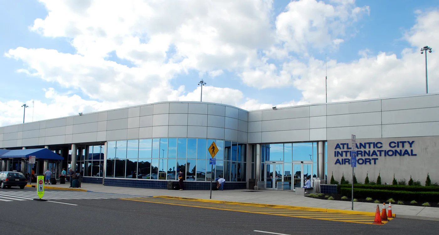
The landside face of the terminal — silver panelling and broad glazing, with 'ATLANTIC CITY INTERNATIONAL AIRPORT' lettered on the right.
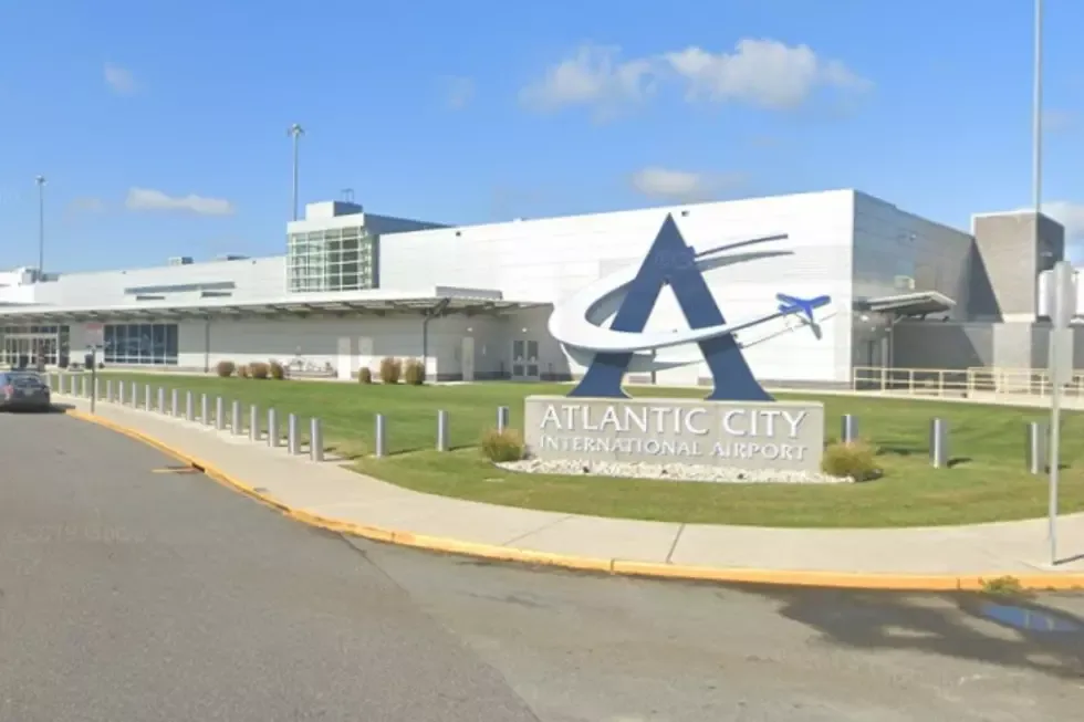
The 'A' monument at the airport entrance: a blue letter slicing through a small aircraft silhouette on the lawn before the terminal.
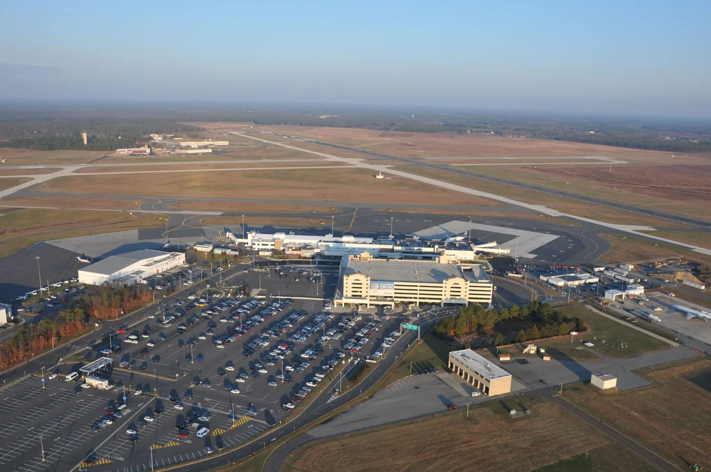
Aerial view of Atlantic City International: terminal and concourse in the middle, car parks and taxiways all around, the city skyline floating on the horizon.
The photos come from public web sources and remain the copyright of their photographers; full credits and source links sit in the photo gallery on this page.
Airport at a glance
| Item | Detail |
|---|---|
| IATA / ICAO | ACY / KACY |
| Role | Medium-sized airport and leisure gateway on the US East Coast |
| Elevation | about 23 m |
| Coordinates | 39.4562, -74.5775 |
| Runways | 2: 13/31 at 3,048 m, 04/22 at 1,873 m |
| Non-stop destinations | 9 (2014 snapshot, all domestic US) |
| Official site | acairport.com |
Network shape: nine destinations, eight listed for Spirit
By distance: 3 destinations within 1,000 km, 6 between 1,000 and 3,000 km, and none beyond 3,000 km. The nearest are Boston (441 km), Myrtle Beach (750 km) and Detroit (799 km). The farthest are Houston (2,163 km), Fort Myers (1,584 km) and Fort Lauderdale (1,576 km). It is an East Coast leisure map: short hops to nearby cities, longer runs to Florida and Texas.
| Distance band | Destinations |
|---|---|
| Under 1,000 km | 3 |
| 1,000–3,000 km | 6 |
| Over 3,000 km | 0 |
Spirit Airlines appears on 8 of the 9 routes, with United Airlines on 2 (some routes list both). The carrier column includes codeshares, so the figures describe concentration. The full list is on the Atlantic City route map.
Getting there and navigating
- Coordinates: 39.4562, -74.5775
- Official site: acairport.com
- Open in a map: Google Maps | Amap | Baidu Maps
If fares are close, compare Westchester County (HPN): about 194 km away with 13 destinations. Joint Base Andrews (ADW) is about 210 km away but has no comparable scheduled-route data. As a leisure airport, ACY sees sharper fare swings around weekends and peak season than a business-oriented field.
The location map on this page shows the field against Atlantic City and the waterfront. Terminal connections and local transport are not covered here; check the airport's or airline's own information.
Before you fly
- The 9 destinations are a 2014 snapshot, and Spirit reshapes its network often. Check the airline's current schedule.
- Spirit is a low-cost carrier: bags, seat selection and changes are priced separately. Compare the total cost, not just the headline fare.
- Leisure traffic peaks around summer weekends and holidays, when security queues run longer. Allow 90–120 minutes and more at peak times.
About the data
Runways, elevation and coordinates come from OurAirports open data. Routes and carriers come from the June 2014 OpenFlights snapshot and include codeshares and interline services; they indicate network shape and scale, not current schedules. Photos are from public web sources and remain the copyright of their photographers.
History
A joint civil-military field about 17 km north-west of Atlantic City, owned and operated by the South Jersey Transportation Authority. It hosts the New Jersey Air National Guard's 177th Fighter Wing (F-16C/Ds) and the U.S. Coast Guard's Atlantic City air station.
Source: Atlantic City Intl Airport.
読者コメントディスカッション
質問、旅行記、訂正など、お気軽にお寄せください。コメントは公開されます。
読み込み中…
コメントを読み込み中…