
Atlantic City International Airport
 Atlantic City · Amerika Serikat· Atlantic City International Airport
Atlantic City International Airport (IATA: ACY, ICAO KACY) adalah bandara sedang yang melayani Atlantic City, Amerika Serikat.
Atlantic City International Airport is a medium-sized airport, at an elevation of about 75 ft, with scheduled passenger service. This page gathers its location map, airport codes and travel information.
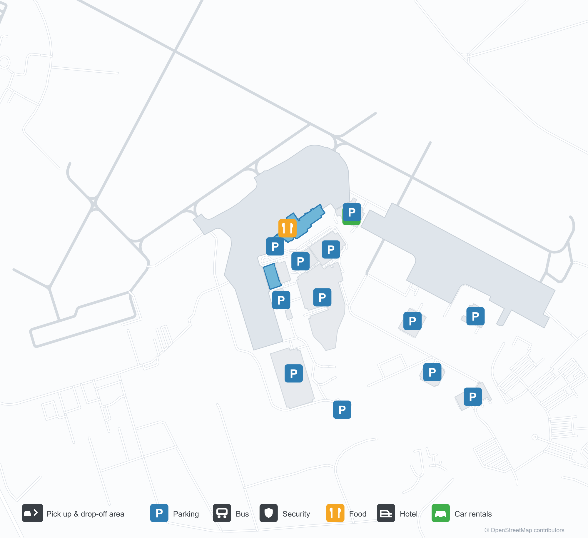
Unduh Peta BandaraUnduhan
Foto bandaraFoto Bandara
Foto asli bandara ini, masing-masing dikreditkan ke halaman web publik tempat foto ditemukan; hak cipta tetap milik fotografer aslinya. Klik foto untuk memperbesar, atau baris kredit untuk membuka halaman sumbernya.
Sisi darat terminal — panel perak dan kaca lebar, dengan tulisan 'ATLANTIC CITY INTERNATIONAL AIRPORT' di sebelah kanan.
Monumen 'A' di pintu masuk bandara: huruf biru menembus siluet pesawat kecil di halaman rumput sebelum terminal.
Pemandangan udara Bandara Internasional Atlantic City: terminal dan concourse di tengah, parkiran dan taxiway di sekelilingnya, cakrawala kota melayang di horizon.
Peta rute Atlantic City International Airport — tujuan langsungPeta Rute
9 tujuan langsung: peta, maskapai yang beroperasi, dan jarak.
Penerbangan Atlantic City International Airport — keberangkatan & kedatanganPapan Penerbangan
160 nomor penerbangan dari 2 maskapai dan 12 tujuan, dipisahkan menurut arah. Nomor codeshare disertakan.
| Penerbangan | Maskapai | Tujuan | Negara/wilayah |
|---|---|---|---|
| G4234 | Allegiant Air | Orlando (SFB) Orlando Sanford International Airport | Amerika Serikat |
| G4245 | Allegiant Air | Orlando (SFB) Orlando Sanford International Airport | Amerika Serikat |
| G4255 | Allegiant Air | Orlando (SFB) Orlando Sanford International Airport | Amerika Serikat |
| G4263 | Allegiant Air | Orlando (SFB) Orlando Sanford International Airport | Amerika Serikat |
| G4482 | Allegiant Air | Fort Lauderdale Hollywood International Airport | Amerika Serikat |
| G4487 | Allegiant Air | Fort Lauderdale Hollywood International Airport | Amerika Serikat |
| G4488 | Allegiant Air | Fort Lauderdale Hollywood International Airport | Amerika Serikat |
| G4489 | Allegiant Air | Fort Lauderdale Hollywood International Airport | Amerika Serikat |
| G4490 | Allegiant Air | Fort Lauderdale Hollywood International Airport | Amerika Serikat |
| G4496 | Allegiant Air | Fort Lauderdale Hollywood International Airport | Amerika Serikat |
| G4498 | Allegiant Air | Fort Lauderdale Hollywood International Airport | Amerika Serikat |
| G4503 | Allegiant Air | Fort Lauderdale Hollywood International Airport | Amerika Serikat |
| G4504 | Allegiant Air | Fort Lauderdale Hollywood International Airport | Amerika Serikat |
| G4506 | Allegiant Air | Fort Lauderdale Hollywood International Airport | Amerika Serikat |
| G4518 | Allegiant Air | Fort Lauderdale Hollywood International Airport | Amerika Serikat |
| G4522 | Allegiant Air | Fort Lauderdale Hollywood International Airport | Amerika Serikat |
| G4526 | Allegiant Air | Fort Lauderdale Hollywood International Airport | Amerika Serikat |
| G4528 | Allegiant Air | Fort Lauderdale Hollywood International Airport | Amerika Serikat |
| G4530 | Allegiant Air | Fort Lauderdale Hollywood International Airport | Amerika Serikat |
| G4851 | Allegiant Air | Punta Gorda (PGD) Punta Gorda Airport | Amerika Serikat |
Nomor penerbangan dan rute dari indeks penerbangan aviability.com (cuplikan 26 Oktober 2026); nomor codeshare disertakan dan waktu keberangkatan tidak ditampilkan. Sumber: aviability.com ↗
Informasi & detail bandaraDetail Bandara
Peta interaktif — lokasi Atlantic City International AirportPeta Interaktif
Lihat bandara ini di layanan peta lain:
Atlantic City Airport (ACY): The 'A' Monument and Nine Domestic RoutesPanduan Bandara
Atlantic City International Airport (IATA ACY, ICAO KACY) introduces itself with a symbol: a large blue letter "A" on the lawn, a small aircraft silhouette cutting through it. The terminal behind is silver panelling and broad glazing, with the airport's full name lettered along the right. From the air, terminal and concourse sit in the middle of car parks and taxiways, with Atlantic City's skyline floating on the horizon. Together the three images describe a domestic airport serving a seaside leisure city.
The field serves Atlantic City, New Jersey, at an elevation of about 23 m, with runways of 3,048 m and 1,873 m. The 2014 route snapshot records 9 non-stop destinations, all in the United States.
Airport photos
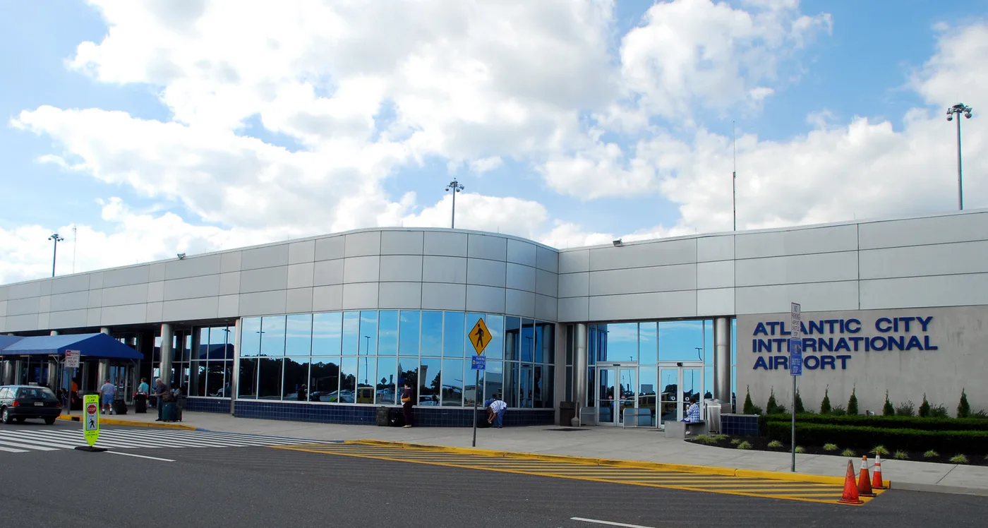
The landside face of the terminal — silver panelling and broad glazing, with 'ATLANTIC CITY INTERNATIONAL AIRPORT' lettered on the right.
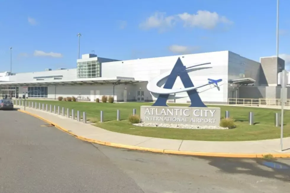
The 'A' monument at the airport entrance: a blue letter slicing through a small aircraft silhouette on the lawn before the terminal.
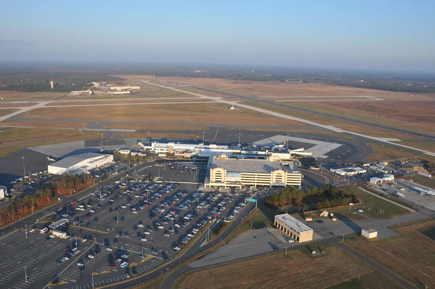
Aerial view of Atlantic City International: terminal and concourse in the middle, car parks and taxiways all around, the city skyline floating on the horizon.
The photos come from public web sources and remain the copyright of their photographers; full credits and source links sit in the photo gallery on this page.
Airport at a glance
| Item | Detail |
|---|---|
| IATA / ICAO | ACY / KACY |
| Role | Medium-sized airport and leisure gateway on the US East Coast |
| Elevation | about 23 m |
| Coordinates | 39.4562, -74.5775 |
| Runways | 2: 13/31 at 3,048 m, 04/22 at 1,873 m |
| Non-stop destinations | 9 (2014 snapshot, all domestic US) |
| Official site | acairport.com |
Network shape: nine destinations, eight listed for Spirit
By distance: 3 destinations within 1,000 km, 6 between 1,000 and 3,000 km, and none beyond 3,000 km. The nearest are Boston (441 km), Myrtle Beach (750 km) and Detroit (799 km). The farthest are Houston (2,163 km), Fort Myers (1,584 km) and Fort Lauderdale (1,576 km). It is an East Coast leisure map: short hops to nearby cities, longer runs to Florida and Texas.
| Distance band | Destinations |
|---|---|
| Under 1,000 km | 3 |
| 1,000–3,000 km | 6 |
| Over 3,000 km | 0 |
Spirit Airlines appears on 8 of the 9 routes, with United Airlines on 2 (some routes list both). The carrier column includes codeshares, so the figures describe concentration. The full list is on the Atlantic City route map.
Getting there and navigating
- Coordinates: 39.4562, -74.5775
- Official site: acairport.com
- Open in a map: Google Maps | Amap | Baidu Maps
If fares are close, compare Westchester County (HPN): about 194 km away with 13 destinations. Joint Base Andrews (ADW) is about 210 km away but has no comparable scheduled-route data. As a leisure airport, ACY sees sharper fare swings around weekends and peak season than a business-oriented field.
The location map on this page shows the field against Atlantic City and the waterfront. Terminal connections and local transport are not covered here; check the airport's or airline's own information.
Before you fly
- The 9 destinations are a 2014 snapshot, and Spirit reshapes its network often. Check the airline's current schedule.
- Spirit is a low-cost carrier: bags, seat selection and changes are priced separately. Compare the total cost, not just the headline fare.
- Leisure traffic peaks around summer weekends and holidays, when security queues run longer. Allow 90–120 minutes and more at peak times.
About the data
Runways, elevation and coordinates come from OurAirports open data. Routes and carriers come from the June 2014 OpenFlights snapshot and include codeshares and interline services; they indicate network shape and scale, not current schedules. Photos are from public web sources and remain the copyright of their photographers.
History
A joint civil-military field about 17 km north-west of Atlantic City, owned and operated by the South Jersey Transportation Authority. It hosts the New Jersey Air National Guard's 177th Fighter Wing (F-16C/Ds) and the U.S. Coast Guard's Atlantic City air station.
Source: Atlantic City Intl Airport.
Komentar pembacaDiskusi
Pertanyaan, laporan perjalanan, dan koreksi sangat kami harapkan. Komentar bersifat publik.
Memuat…
Memuat komentar…