
Asaba International Airport
 Asaba · Nijerya· Asaba International Airport
Asaba International Airport (IATA: ABB, ICAO DNAS), Asaba, Nijerya kentine hizmet veren bir büyük havalimanıdır.
Asaba International Airport is a large airport, at an elevation of about 305 ft, with scheduled passenger service. This page gathers its location map, airport codes and travel information.
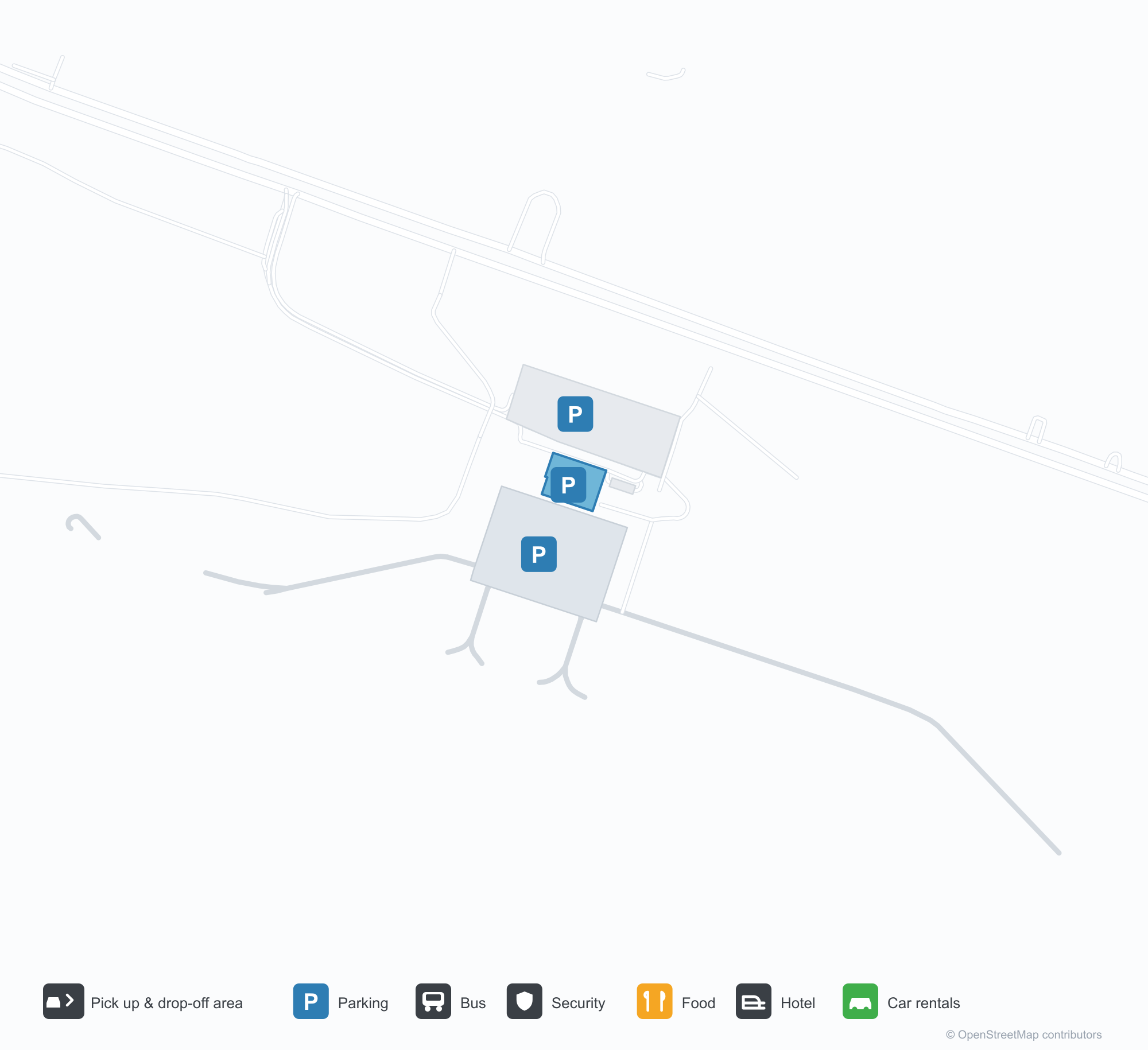
Havalimanı Haritalarını İndirinİndirmeler
Havalimanı fotoğraflarıHavalimanı Fotoğrafları
Bu havalimanının gerçek fotoğrafları; her fotoğrafın altında, fotoğrafın bulunduğu kamuya açık web sayfasına bir atıf yer alır ve telif hakkı özgün fotoğrafçılarda kalır. Yakınlaştırmak için bir fotoğrafa, kaynak sayfasını açmak için bir atıf satırına tıklayın.
Asaba Uluslararası Havalimanı'na havadan bakış: pistin yanındaki kemerli terminal çatıları ve koyu renkli kontrol kulesi; ön planda kırmızı-beyaz itfaiye istasyonu ve bir yakıt kamyonu.
Terminalin ön yüzü ve otoparkı — kemerli cepheye yerleştirilmiş üçgen cam giydirme cephe; kontrol kulesi solda.
Terminal aprondan görünüyor: bağımsız kontrol kulesinin yanındaki beyaz tonozlu çatılar, sıralar halindeki projektör direklerinin altında.
Asaba International Airport rota haritası — doğrudan varış noktalarıRota Haritası
2 doğrudan varış noktası: harita, sefer yapan havayolu şirketleri ve mesafeler.
Asaba International Airport uçuşları — kalkışlar ve varışlarUçuş Panosu
36 uçuş numarası, 5 havayolu şirketi ve 2 varış noktası, yönlere göre ayrılmıştır. Ortak uçuş numaraları dahildir.
| Uçuş | Havayolu şirketi | Varış noktası | Ülke/bölge |
|---|---|---|---|
| A16317 | Apg Airlines | Abuja (ABV) Nnamdi Azikiwe International Airport | Nijerya |
| A16328 | Apg Airlines | Abuja (ABV) Nnamdi Azikiwe International Airport | Nijerya |
| A16330 | Apg Airlines | Murtala Muhammed International Airport | Nijerya |
| A16499 | Apg Airlines | Murtala Muhammed International Airport | Nijerya |
| N2192 | Aero Contractors | Murtala Muhammed International Airport | Nijerya |
| N2194 | Aero Contractors | Murtala Muhammed International Airport | Nijerya |
| N2196 | Aero Contractors | Abuja (ABV) Nnamdi Azikiwe International Airport | Nijerya |
| P47861 | Air Peace | Abuja (ABV) Nnamdi Azikiwe International Airport | Nijerya |
| P47863 | Air Peace | Murtala Muhammed International Airport | Nijerya |
| P47865 | Air Peace | Abuja (ABV) Nnamdi Azikiwe International Airport | Nijerya |
| P47867 | Air Peace | Murtala Muhammed International Airport | Nijerya |
| P47869 | Air Peace | Murtala Muhammed International Airport | Nijerya |
| UN507 | United Nigeria Airlines | Abuja (ABV) Nnamdi Azikiwe International Airport | Nijerya |
| UN509 | United Nigeria Airlines | Murtala Muhammed International Airport | Nijerya |
| UN523 | United Nigeria Airlines | Murtala Muhammed International Airport | Nijerya |
| UN607 | United Nigeria Airlines | Abuja (ABV) Nnamdi Azikiwe International Airport | Nijerya |
| UN609 | United Nigeria Airlines | Murtala Muhammed International Airport | Nijerya |
| W3629 | Arik Air | Murtala Muhammed International Airport | Nijerya |
Uçuş numaraları ve rotalar aviability.com uçuş dizininden (anlık görüntü: 26 Ekim 2026); ortak uçuş numaraları dahildir ve kalkış saatleri gösterilmez. Kaynak: aviability.com ↗
Havalimanı bilgileri ve ayrıntılarıHavalimanı Ayrıntıları
Etkileşimli harita — Asaba International Airport konumuEtkileşimli Harita
Bu havalimanını diğer harita hizmetlerinde görüntüleyin:
Asaba International Airport (ABB): An International Name, Two Domestic RoutesHavalimanı Rehberi
Asaba International Airport (IATA ABB, ICAO DNAS) carries "international" in its name, but the photos start somewhere else: vaulted terminal roofs and a dark control tower beside the runway, with a red-and-white fire station and a fuel truck in the foreground; a triangular glass curtain wall set into the arched façade; white vaulted roofs seen from the apron under rows of floodlights. The field sits in Asaba, Nigeria, at an elevation of about 93 m, with a single 3,400 m runway running past the terminal.
That runway length sits oddly against the route table. The 2014 OpenFlights snapshot records just two non-stop destinations, Abuja (319 km) and Lagos (372 km), both inside Nigeria. A 3,400 m runway is not what two short domestic hops require; it reads as an investment aimed at larger aircraft and longer routes.
Airport photos
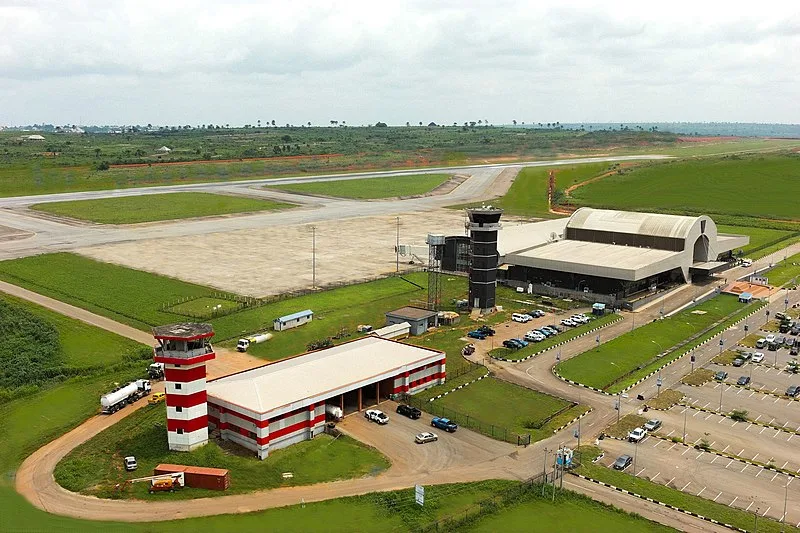
Aerial view of Asaba International Airport: the arched terminal roofs and dark control tower beside the runway, with the red-and-white fire station and a fuel truck down in the foreground.
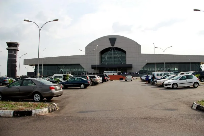
The terminal front and its car park — a triangular glass curtain wall set into the arched façade, with the control tower to the left.
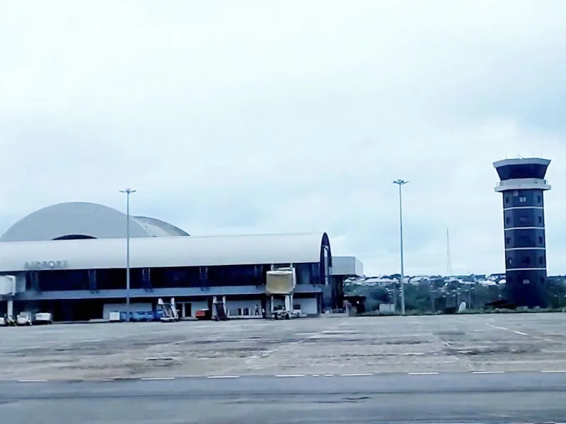
The terminal seen from the apron: white vaulted roofs beside the freestanding control tower, under rows of floodlight masts.
The photos come from public web sources and remain the copyright of their photographers; full credits and source links sit in the photo gallery on this page.
Airport at a glance
| Item | Detail |
|---|---|
| IATA / ICAO | ABB / DNAS |
| Role | Large airport by this site's classification; regional gateway in southern Nigeria |
| Elevation | about 93 m |
| Coordinates | 6.2042, 6.6653 |
| Runway | 1: 11/29, 3,400 m, 58 m wide |
| Non-stop destinations | 2 (Abuja, Lagos; 2014 snapshot) |
Network shape: two routes, both under 500 km
The two routes go to Abuja (319 km) and Lagos (372 km), both inside the under-1,000 km band. The carrier column lists only World Scale Airlines, which looks like a 2014 data label rather than a current operator; do not treat it as a live airline list.
| Distance band | Destinations |
|---|---|
| Under 1,000 km | 2 |
| Over 1,000 km | 0 |
Two routes mean Asaba's external connections depend heavily on Lagos and Abuja. For anywhere outside Nigeria, the usual pattern is to fly to one of those cities and change to an international service. The full two-route record is on the Asaba route map.
Getting there and navigating
- Coordinates: 6.2042, 6.6653
- Open in a map: Google Maps | Amap | Baidu Maps
The nearest large airport in the comparison table is Pointe-Noire (PNR), about 1,356 km away with 9 destinations — not a practical substitute for everyday travel. The useful alternatives are the two cities already on Asaba's own route map, Lagos (LOS) and Abuja (ABV), both major nodes in Nigeria's domestic network.
The location map on this page shows the field against Asaba and the road network. Terminal connections and local transport are not covered here; check the airport's or airline's own information.
Before you fly
- The two routes are a 2014 snapshot, and Nigerian domestic schedules change quickly. Confirm with the airline that the flight is operating after booking.
- With one runway and a compact terminal, 90–120 minutes before departure is usually enough; for an international connection, include the transfer time in Lagos or Abuja.
- The fire station, fuel truck and floodlight masts in the photos show a fully equipped field, but runway length does not mean large aircraft appear daily. Follow the actual schedule.
About the data
Runways, elevation and coordinates come from OurAirports open data. Routes and carriers come from the June 2014 OpenFlights snapshot and include codeshares and interline services; they indicate network shape and scale, not current schedules. Photos are from public web sources and remain the copyright of their photographers.
Okuyucu yorumlarıTartışma
Sorular, seyahat deneyimleri ve düzeltmeler memnuniyetle karşılanır. Yorumlar herkese açıktır.
Yükleniyor…
Yorumlar yükleniyor…