
Asaba International Airport
 Asaba · 나이지리아· Asaba International Airport
Asaba International Airport(IATA: ABB, ICAO: DNAS)은 나이지리아 Asaba에 위치한 대형 공항입니다.
Asaba International Airport is a large airport, at an elevation of about 305 ft, with scheduled passenger service. This page gathers its location map, airport codes and travel information.
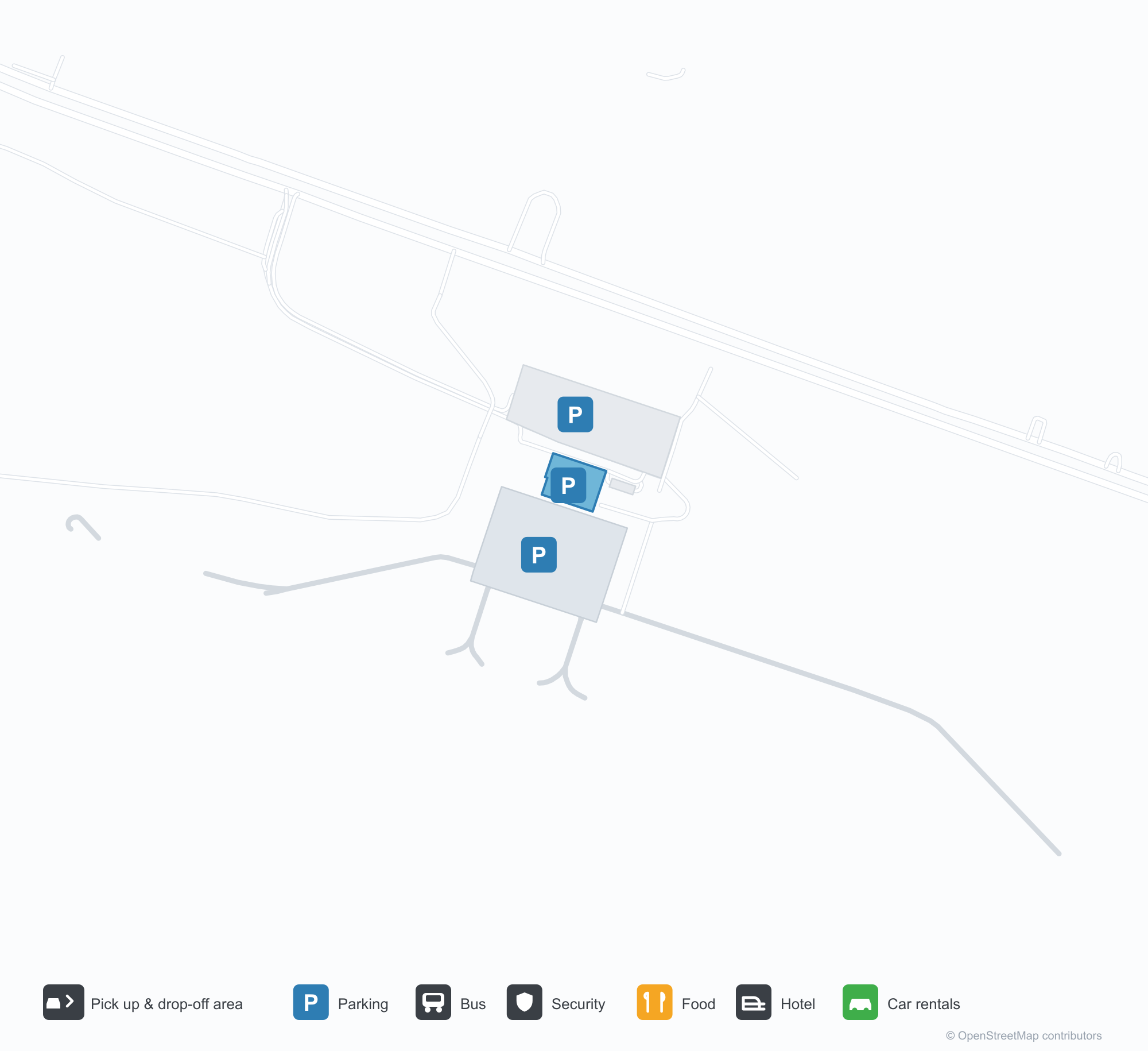
공항 지도 다운로드다운로드
공항 실제 사진공항 사진
다음은 이 공항의 실제 사진으로, 모두 공개된 인터넷 출처에서 가져왔으며 사진마다 출처를 표시했습니다. 저작권은 원저작자에게 있습니다. 사진을 클릭하면 크게 볼 수 있고, 출처를 클릭하면 원본 페이지가 열립니다.
공중에서 본 아사바 국제공항: 활주로 옆의 아치형 터미널 지붕과 어두운 관제탑, 앞쪽 아래로 붉고 흰 소방서와 급유차.
터미널 정면과 주차장 — 아치형 외벽 안에 자리한 삼각형 유리 커튼월, 왼쪽의 관제탑.
계류장에서 본 터미널: 홀로 선 관제탑 옆의 흰 둥근 지붕들, 그 위로 줄지어 선 조명탑.
Asaba International Airport 노선도 · 직항 목적지노선도
직항 목적지 2개: 노선도, 운항 항공사, 비행 거리.
공항 정보 및 상세공항 상세
Asaba International Airport 인터랙티브 지도 — 공항 위치인터랙티브 지도
다른 지도 서비스에서 이 공항 보기:
Asaba International Airport (ABB): An International Name, Two Domestic Routes공항 안내
Asaba International Airport (IATA ABB, ICAO DNAS) carries "international" in its name, but the photos start somewhere else: vaulted terminal roofs and a dark control tower beside the runway, with a red-and-white fire station and a fuel truck in the foreground; a triangular glass curtain wall set into the arched façade; white vaulted roofs seen from the apron under rows of floodlights. The field sits in Asaba, Nigeria, at an elevation of about 93 m, with a single 3,400 m runway running past the terminal.
That runway length sits oddly against the route table. The 2014 OpenFlights snapshot records just two non-stop destinations, Abuja (319 km) and Lagos (372 km), both inside Nigeria. A 3,400 m runway is not what two short domestic hops require; it reads as an investment aimed at larger aircraft and longer routes.
Airport photos
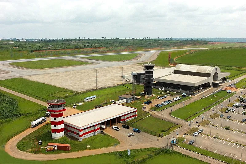
Aerial view of Asaba International Airport: the arched terminal roofs and dark control tower beside the runway, with the red-and-white fire station and a fuel truck down in the foreground.
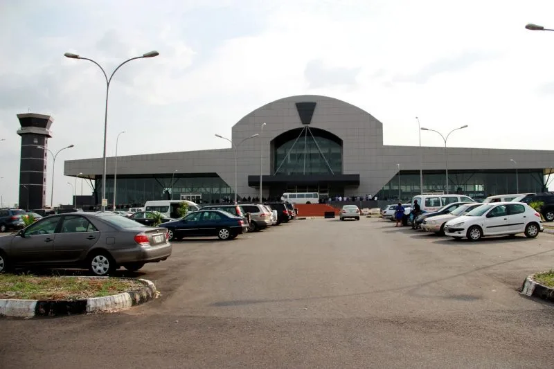
The terminal front and its car park — a triangular glass curtain wall set into the arched façade, with the control tower to the left.
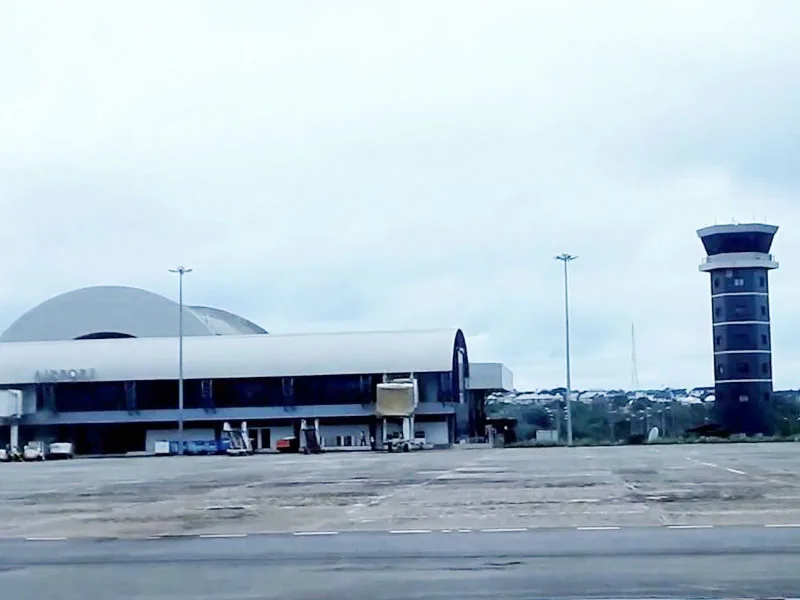
The terminal seen from the apron: white vaulted roofs beside the freestanding control tower, under rows of floodlight masts.
The photos come from public web sources and remain the copyright of their photographers; full credits and source links sit in the photo gallery on this page.
Airport at a glance
| Item | Detail |
|---|---|
| IATA / ICAO | ABB / DNAS |
| Role | Large airport by this site's classification; regional gateway in southern Nigeria |
| Elevation | about 93 m |
| Coordinates | 6.2042, 6.6653 |
| Runway | 1: 11/29, 3,400 m, 58 m wide |
| Non-stop destinations | 2 (Abuja, Lagos; 2014 snapshot) |
Network shape: two routes, both under 500 km
The two routes go to Abuja (319 km) and Lagos (372 km), both inside the under-1,000 km band. The carrier column lists only World Scale Airlines, which looks like a 2014 data label rather than a current operator; do not treat it as a live airline list.
| Distance band | Destinations |
|---|---|
| Under 1,000 km | 2 |
| Over 1,000 km | 0 |
Two routes mean Asaba's external connections depend heavily on Lagos and Abuja. For anywhere outside Nigeria, the usual pattern is to fly to one of those cities and change to an international service. The full two-route record is on the Asaba route map.
Getting there and navigating
- Coordinates: 6.2042, 6.6653
- Open in a map: Google Maps | Amap | Baidu Maps
The nearest large airport in the comparison table is Pointe-Noire (PNR), about 1,356 km away with 9 destinations — not a practical substitute for everyday travel. The useful alternatives are the two cities already on Asaba's own route map, Lagos (LOS) and Abuja (ABV), both major nodes in Nigeria's domestic network.
The location map on this page shows the field against Asaba and the road network. Terminal connections and local transport are not covered here; check the airport's or airline's own information.
Before you fly
- The two routes are a 2014 snapshot, and Nigerian domestic schedules change quickly. Confirm with the airline that the flight is operating after booking.
- With one runway and a compact terminal, 90–120 minutes before departure is usually enough; for an international connection, include the transfer time in Lagos or Abuja.
- The fire station, fuel truck and floodlight masts in the photos show a fully equipped field, but runway length does not mean large aircraft appear daily. Follow the actual schedule.
About the data
Runways, elevation and coordinates come from OurAirports open data. Routes and carriers come from the June 2014 OpenFlights snapshot and include codeshares and interline services; they indicate network shape and scale, not current schedules. Photos are from public web sources and remain the copyright of their photographers.