
Aerotortuguero Airport
 Tulum · คอสตาริกา· Aerotortuguero Airport
Aerotortuguero Airport (IATA: TTQ, ICAO MRAO) เป็นสนามบินขนาดกลางที่ให้บริการTulum, คอสตาริกา
Aerotortuguero Airport is a medium-sized airport, at an elevation of about 19 ft. This page gathers its location map, airport codes and travel information.

ดาวน์โหลดแผนที่สนามบินดาวน์โหลด
ภาพสนามบินภาพสนามบิน
ภาพจริงของสนามบินแห่งนี้ พร้อมเครดิตของหน้าเว็บสาธารณะที่พบภาพ; ลิขสิทธิ์ยังเป็นของผู้ถ่ายภาพต้นฉบับ คลิกที่ภาพเพื่อขยาย หรือคลิกบรรทัดเครดิตเพื่อเปิดหน้าแหล่งที่มา
ทางวิ่งของตอร์ตูเกโร — เครื่องบินเซสนาแคระแวนของ Nature Air (TI-BDY) บนแอสฟัลต์ ศาลาพักคอยหลังคาสีเขียวเล็ก ๆ และป่าฝนอยู่ติดหลังปีก (ภาพ: Sebastian Arndt / Flugzeugbilder.de)
ทางวิ่งแอสฟัลต์ว่างเปล่าทอดตรงไปยังต้นไม้เขตร้อนทึบ เส้นกลางทางสีขาวและเครื่องหมายหัวทางวิ่งคมชัดระหว่างไหล่หญ้าและรั้วตาข่ายสีเขียว
เครื่องบินใบพัดเครื่องยนต์เดียวสีขาวลำเล็กหันหน้าเข้าหากล้องบนลานคอนกรีต มีกรวยสีส้มสองอันบนหญ้าด้านหน้าและต้นปาล์มตัดกับท้องฟ้าสีฟ้าด้านหลัง
มองผ่านหน้าต่างห้องโดยสาร ฝาครอบเครื่องยนต์สีขาวที่มีเครื่องหมายสีแดงและใบพัดที่หมุนอยู่ล้อมกรอบลานจอดไกล ๆ ที่อากาศยานสีฟ้าขาวลำเล็กอีกลำรออยู่ข้างศาลาหลังคาแดง
เครื่องบินใบพัดสีขาวจอดตะแคงอยู่บนลานจอด มีแถบสีแดงและน้ำเงินบนหาง ทะเบียนบนลำตัว พร้อมต้นปาล์มและท้องฟ้าสีน้ำเงินเข้มรอบ ๆ
บนตลิ่งริมน้ำเขตร้อน ศาลาไม้หลังคาสีเขียวอยู่ในร่มเงาต้นไม้ ขณะที่นกกระสันยืนอยู่บนหญ้าเหนือผืนน้ำสีเข้มนิ่งสงบ
เที่ยวบินของAerotortuguero Airport — ขาออกและขาเข้าป้ายเที่ยวบิน
4 หมายเลขเที่ยวบิน ครอบคลุม 1 สายการบิน และ 3 จุดหมายปลายทาง แยกตามทิศทาง หมายเลขเที่ยวบินร่วม (codeshare) รวมอยู่ด้วย
| เที่ยวบิน | สายการบิน | จุดหมายปลายทาง | ประเทศ/ภูมิภาค |
|---|---|---|---|
| RZ1122 | Sansa Airlines | La Fortuna Arenal Airport | คอสตาริกา |
| RZ1132 | Sansa Airlines | Limón (LIO) Limón International Airport | คอสตาริกา |
หมายเลขเที่ยวบินและเส้นทางจากดัชนีเที่ยวบิน aviability.com (ข้อมูล ณ วันที่ 26 ตุลาคม 2569); รวมหมายเลขเที่ยวบินร่วมและไม่แสดงเวลาเดินทาง ที่มา: aviability.com ↗
ข้อมูลและรายละเอียดสนามบินรายละเอียดสนามบิน
แผนที่อินเทอร์แอกทีฟ — ตำแหน่ง Aerotortuguero Airportแผนที่อินเทอร์แอกทีฟ
ดูสนามบินนี้บนบริการแผนที่อื่น:
Tortuguero Airport (TTQ): A Rainforest Runway and a Name Mix-Upคู่มือสนามบิน
A Nature Air Cessna Caravan stands on Tortuguero's asphalt runway, the green-roofed shelter and rainforest right behind its wing. The field serves Tortuguero in Costa Rica at an elevation of about 6 m, with a 950 m runway; the 2014 snapshot records no scheduled routes. One correction: the old entry on this site labelled TTQ as "Tulum", but both the coordinates and the photo point to Tortuguero in Costa Rica, not Tulum in Mexico.
Airport photos
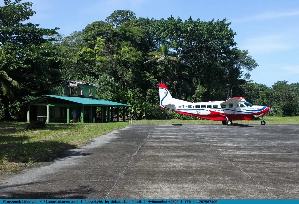
The Tortuguero airstrip — a Nature Air Cessna Caravan (TI-BDY) on the asphalt, the small green-roofed waiting shed and rainforest right behind the wing (photo: Sebastian Arndt / Flugzeugbilder.de).
The photos come from public web sources and remain the copyright of their photographers; full credits and source links sit in the photo gallery on this page.
Airport at a glance
| Item | Detail |
|---|---|
| IATA / ICAO | TTQ / MRAO |
| Role | Medium-sized airport |
| Elevation | about 6 m |
| Coordinates | 10.5690, -83.5149 |
| Runways | 1, 950 m |
| Non-stop destinations | 0 in the 2014 snapshot |
Runways
| Runway | Length | Width | Surface |
|---|---|---|---|
| 02/20 | 950 m | 12 m | asphalt |
1 runway, the longest 950 m.
Non-stop routes
The route dataset carries no scheduled non-stop services for this airport. Regional schedules change often — confirm with the airline or airport before booking.
Nearby airports to compare
If the fares are close, these are the nearest airports of the same class (medium-sized airport) — straight-line distance, with their own non-stop counts from the same dataset:
| Airport | Distance | Non-stop destinations |
|---|---|---|
| La Fortuna Arenal Airport (FON) | ~117 km | 2 |
| Alonso Valderrama Airport (CTD) | ~446 km | — |
Before you fly
- Small aircraft and charters dominate, with strict baggage limits; confirm the aircraft and baggage rules when booking.
- Tortuguero is known for rainforest and turtles; with no scheduled routes recorded, lodges or charters usually arrange the flight.
About the data
Runways, elevation and coordinates come from OurAirports open data. Routes and carriers come from the June 2014 OpenFlights snapshot and include codeshares and interline services; they indicate network shape and scale, not current schedules.
History
Serving the Tortuguero national-park area, the strip's scheduled flights are flown by Nature Air and Sansa, mostly routing to San José via Barra del Colorado.
Source: Aerotortuguero Airport.
ความคิดเห็นจากผู้อ่านการสนทนา
ยินดีรับคำถาม รายงานการเดินทาง และการแก้ไข ความคิดเห็นเป็นสาธารณะ
กำลังโหลด…
กำลังโหลดความคิดเห็น…