
Comodoro Arturo Merino Benítez International Airport
 ซันติอาโก · ชิลี· Comodoro Arturo Merino Benítez International Airport
Comodoro Arturo Merino Benítez International Airport (IATA: SCL, ICAO SCEL) เป็นสนามบินขนาดใหญ่ที่ให้บริการซันติอาโก, ชิลี
Comodoro Arturo Merino Benítez International Airport is a large airport, at an elevation of about 1,555 ft, with scheduled passenger service. This page gathers its location map, airport codes and travel information.
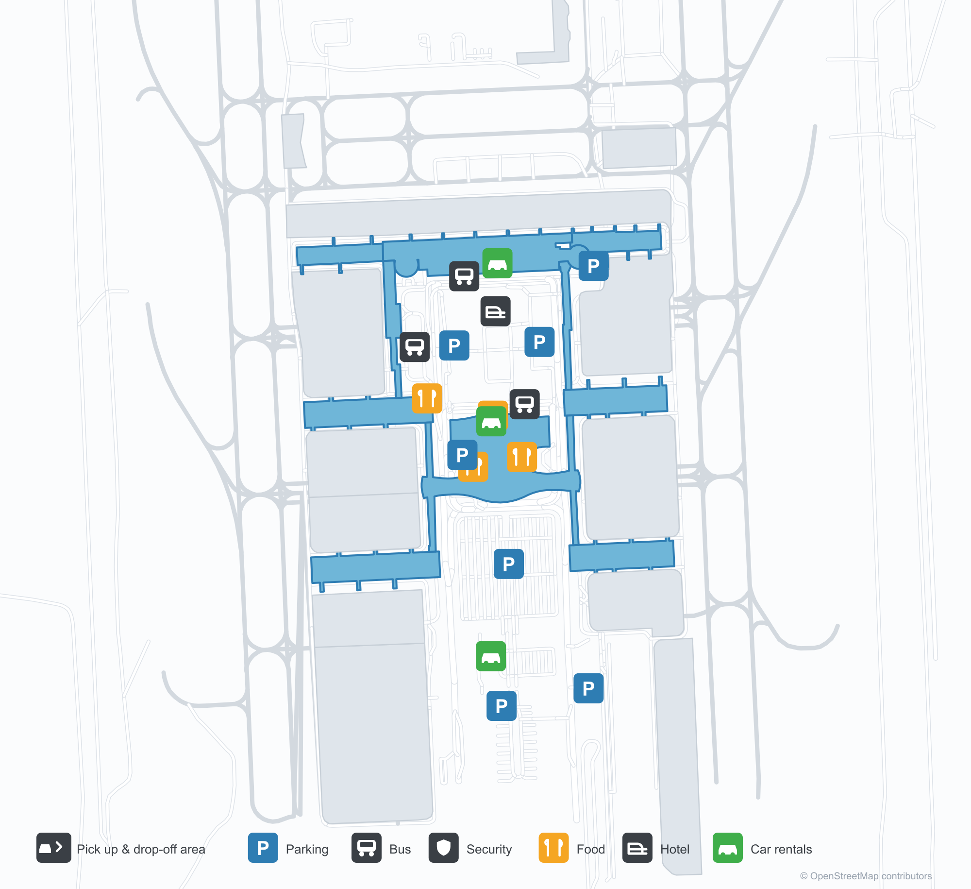
ดาวน์โหลดแผนที่สนามบินดาวน์โหลด
ภาพสนามบินภาพสนามบิน
ภาพจริงของสนามบินแห่งนี้ พร้อมเครดิตของหน้าเว็บสาธารณะที่พบภาพ; ลิขสิทธิ์ยังเป็นของผู้ถ่ายภาพต้นฉบับ คลิกที่ภาพเพื่อขยาย หรือคลิกบรรทัดเครดิตเพื่อเปิดหน้าแหล่งที่มา
อาคารผู้โดยสารมองจากด้านนอก — หลังคาโค้งคลุมด้านหน้าเหล็กและกระจก ทางเดินเชื่อมถนนกับลานจอดรถ
แผนที่เส้นทาง Comodoro Arturo Merino Benítez International Airport — จุดหมายบินตรงแผนที่เส้นทาง
40 จุดหมายบินตรง: แผนที่ สายการบินที่ให้บริการ และระยะทาง
เที่ยวบินของComodoro Arturo Merino Benítez International Airport — ขาออกและขาเข้าป้ายเที่ยวบิน
2,534 หมายเลขเที่ยวบิน ครอบคลุม 34 สายการบิน และ 66 จุดหมายปลายทาง แยกตามทิศทาง หมายเลขเที่ยวบินร่วม (codeshare) รวมอยู่ด้วย
| เที่ยวบิน | สายการบิน | จุดหมายปลายทาง | ประเทศ/ภูมิภาค |
|---|---|---|---|
| AA912 | American Airlines | ท่าอากาศยานนานาชาติไมแอมี | สหรัฐอเมริกา |
| AA940 | American Airlines | Dallas Fort Worth International Airport | สหรัฐอเมริกา |
| AA7781 | American Airlines | Antofagasta (ANF) Andrés Sabella Gálvez International Airport | ชิลี |
| AA7782 | American Airlines | Antofagasta (ANF) Andrés Sabella Gálvez International Airport | ชิลี |
| AA7782 | American Airlines | Concepcion (CCP) Carriel Sur International Airport | ชิลี |
| AA7784 | American Airlines | Concepcion (CCP) Carriel Sur International Airport | ชิลี |
| AA7784 | American Airlines | Calama (CJC) El Loa Airport | ชิลี |
| AA7784 | American Airlines | Iquique (IQQ) Diego Aracena International Airport | ชิลี |
| AA7784 | American Airlines | Temuco (ZCO) La Araucanía International Airport | ชิลี |
| AA7786 | American Airlines | Antofagasta (ANF) Andrés Sabella Gálvez International Airport | ชิลี |
| AA7786 | American Airlines | Puerto Montt (PMC) El Tepual International Airport | ชิลี |
| AA7787 | American Airlines | Antofagasta (ANF) Andrés Sabella Gálvez International Airport | ชิลี |
| AA7787 | American Airlines | Iquique (IQQ) Diego Aracena International Airport | ชิลี |
| AA7789 | American Airlines | Calama (CJC) El Loa Airport | ชิลี |
| AA7789 | American Airlines | Mendoza (MDZ) Governor Francisco Gabrielli International Airport | อาร์เจนตินา |
| AA7790 | American Airlines | Concepcion (CCP) Carriel Sur International Airport | ชิลี |
| AA7792 | American Airlines | Antofagasta (ANF) Andrés Sabella Gálvez International Airport | ชิลี |
| AA7792 | American Airlines | Temuco (ZCO) La Araucanía International Airport | ชิลี |
| AA7793 | American Airlines | Antofagasta (ANF) Andrés Sabella Gálvez International Airport | ชิลี |
| AA7795 | American Airlines | Concepcion (CCP) Carriel Sur International Airport | ชิลี |
หมายเลขเที่ยวบินและเส้นทางจากดัชนีเที่ยวบิน aviability.com (ข้อมูล ณ วันที่ 26 ตุลาคม 2569); รวมหมายเลขเที่ยวบินร่วมและไม่แสดงเวลาเดินทาง ที่มา: aviability.com ↗
ข้อมูลและรายละเอียดสนามบินรายละเอียดสนามบิน
แผนที่อินเทอร์แอกทีฟ — ตำแหน่ง Comodoro Arturo Merino Benítez International Airportแผนที่อินเทอร์แอกทีฟ
ดูสนามบินนี้บนบริการแผนที่อื่น:
Santiago Airport (SCL): Two Parallel Runways and Chile's Long-Haul Gatewayคู่มือสนามบิน
Santiago's terminal presents itself as a single arched roof spanning a steel-and-glass frontage, with a walkway connecting the roadway directly to the car parks. The airport sits in Santiago, Chile, at an elevation of about 474 m, and its two parallel runways — 17L/35R and 17R/35L — are both 3,750 m long. For a capital-city airport, that pairing means it can handle widebody arrivals and departures at the same time.
In the 2014 route snapshot, 13 of SCL's 40 non-stop destinations are in Chile and 27 are abroad. The domestic network runs north–south along the Andes, while the international map reaches neighbours, Europe and Oceania.
Airport photos
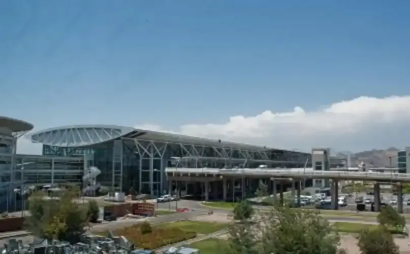
The terminal from outside — an arched roof spanning the steel-and-glass frontage, a walkway linking the roadway to the car parks.
The photos come from public web sources and remain the copyright of their photographers; full credits and source links sit in the photo gallery on this page.
Airport at a glance
| Item | Detail |
|---|---|
| IATA / ICAO | SCL / SCEL |
| Role | Large international airport and Chile's long-haul gateway |
| Elevation | about 474 m |
| Coordinates | -33.3930, -70.7858 |
| Runways | 2 parallel, both 3,750 m |
| Non-stop destinations | 40 (13 domestic, 27 international; 2014 snapshot) |
| Official site | aeropuertosantiago.cl |
Network shape: half in South America, half far away
Group the 40 routes by distance: 8 within 1,000 km, 13 between 1,000 and 3,000 km, 8 between 3,000 and 6,000 km, and 11 beyond 6,000 km. The short layer is the South American west coast — Mendoza at 196 km, La Serena at 389 km, Concepción at 429 km. The long layer includes Madrid (10,719 km), Sydney (11,340 km) and Paris (11,673 km). With 11 routes beyond 6,000 km — a quarter of the total — SCL is more than Chile's domestic hub: it is the southern cone's outlet to Europe and Oceania.
| Distance band | Destinations |
|---|---|
| Under 1,000 km | 8 |
| 1,000–3,000 km | 13 |
| 3,000–6,000 km | 8 |
| Over 6,000 km | 11 |
LAN Airlines (now LATAM) appears on 35 of the 40 routes and Sky Airline on 10. The carrier column includes codeshares, so these figures describe network concentration rather than who operates every flight. The full list is on the Santiago route map.
Getting there and navigating
- Coordinates: -33.3930, -70.7858
- Official site: aeropuertosantiago.cl
- Open in a map: Google Maps | Amap | Baidu Maps
If fares are close, the nearest large-airport comparison in the snapshot is Córdoba, Argentina (COR): about 660 km away with 11 destinations. Travellers heading to Buenos Aires should watch the airport code — AEP and EZE serve different roles, one as the city airport and one for long-haul international flights.
The location map on this page shows the field against Santiago and the surrounding road network. This page does not cover terminal connections or local transport; confirm them with the airport or airline.
Before you fly
- Allow 2–3 hours for an international departure and 90–120 minutes for a domestic one. Two runways do not guarantee short queues, especially at morning and evening peaks.
- The 40 destinations are a 2014 snapshot; LATAM and Sky have both reshaped their networks since. Check current schedules with the airline.
- Flights to Europe and Oceania are 10 hours or more, so seat choice and connection buffers deserve more attention than on a regional trip.
About the data
Runways, elevation and coordinates come from OurAirports open data. Routes and carriers come from the June 2014 OpenFlights snapshot and include codeshares and interline services; they indicate network shape and scale, not current schedules. Photos are from public web sources and remain the copyright of their photographers.
History
Fifteen kilometres north-west of downtown Santiago, Arturo Merino Benítez is Chile's largest aviation facility and its busiest international airport, also known as Nuevo Pudahuel.
Source: Arturo Merino Benítez International Airport.
ความคิดเห็นจากผู้อ่านการสนทนา
ยินดีรับคำถาม รายงานการเดินทาง และการแก้ไข ความคิดเห็นเป็นสาธารณะ
กำลังโหลด…
กำลังโหลดความคิดเห็น…