
Indianapolis International Airport
 Indianapolis · สหรัฐอเมริกา· Indianapolis International Airport
Indianapolis International Airport (IATA: IND, ICAO KIND) เป็นสนามบินขนาดกลางที่ให้บริการIndianapolis, สหรัฐอเมริกา
Indianapolis International Airport (IND) is a medium airport serving Indianapolis, United States. This page gathers the airport codes, location map and travel information.
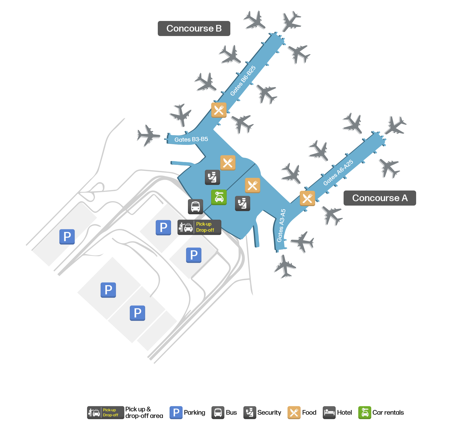
ดาวน์โหลดแผนที่สนามบินดาวน์โหลด
ภาพสนามบินภาพสนามบิน
ภาพจริงของสนามบินแห่งนี้ พร้อมเครดิตของหน้าเว็บสาธารณะที่พบภาพ; ลิขสิทธิ์ยังเป็นของผู้ถ่ายภาพต้นฉบับ คลิกที่ภาพเพื่อขยาย หรือคลิกบรรทัดเครดิตเพื่อเปิดหน้าแหล่งที่มา
อินเดียแนโพลิสยามพลบค่ำ หลังคาเหล็กโค้งกว้างของอาคารผู้โดยสารเปล่งประกายตัดกับท้องฟ้าสีน้ำเงินเข้มเหนือถนนขาออกที่ว่างเปล่า
ในภาพถ่ายดาวเทียม มองเห็นผังของสนามบินนานาชาติอินเดียแนโพลิส (IND) และบริเวณโดยรอบได้อย่างชัดเจน
แผนที่เส้นทาง Indianapolis International Airport — จุดหมายบินตรงแผนที่เส้นทาง
35 จุดหมายบินตรง: แผนที่ สายการบินที่ให้บริการ และระยะทาง
เที่ยวบินของIndianapolis International Airport — ขาออกและขาเข้าป้ายเที่ยวบิน
3,621 หมายเลขเที่ยวบิน ครอบคลุม 48 สายการบิน และ 53 จุดหมายปลายทาง แยกตามทิศทาง หมายเลขเที่ยวบินร่วม (codeshare) รวมอยู่ด้วย
| เที่ยวบิน | สายการบิน | จุดหมายปลายทาง | ประเทศ/ภูมิภาค |
|---|---|---|---|
| AA346 | American Airlines | Charlotte Douglas International Airport | สหรัฐอเมริกา |
| AA499 | American Airlines | ท่าอากาศยานนานาชาติลอสแอนเจลิส | สหรัฐอเมริกา |
| AA500 | American Airlines | Dallas Fort Worth International Airport | สหรัฐอเมริกา |
| AA520 | American Airlines | Charlotte Douglas International Airport | สหรัฐอเมริกา |
| AA528 | American Airlines | Phoenix Sky Harbor International Airport | สหรัฐอเมริกา |
| AA531 | American Airlines | Charlotte Douglas International Airport | สหรัฐอเมริกา |
| AA536 | American Airlines | ท่าอากาศยานนานาชาติไมแอมี | สหรัฐอเมริกา |
| AA558 | American Airlines | Charlotte Douglas International Airport | สหรัฐอเมริกา |
| AA564 | American Airlines | Phoenix Sky Harbor International Airport | สหรัฐอเมริกา |
| AA586 | American Airlines | ท่าอากาศยานนานาชาติลอสแอนเจลิส | สหรัฐอเมริกา |
| AA598 | American Airlines | ท่าอากาศยานนานาชาติลอสแอนเจลิส | สหรัฐอเมริกา |
| AA608 | American Airlines | Charlotte Douglas International Airport | สหรัฐอเมริกา |
| AA620 | American Airlines | ท่าอากาศยานนานาชาติไมแอมี | สหรัฐอเมริกา |
| AA817 | American Airlines | Charlotte Douglas International Airport | สหรัฐอเมริกา |
| AA961 | American Airlines | Phoenix Sky Harbor International Airport | สหรัฐอเมริกา |
| AA1063 | American Airlines | ท่าอากาศยานนานาชาติซีแอตเทิล-ทาโคมา | สหรัฐอเมริกา |
| AA1109 | American Airlines | ท่าอากาศยานนานาชาติไมแอมี | สหรัฐอเมริกา |
| AA1191 | American Airlines | ท่าอากาศยานนานาชาติไมแอมี | สหรัฐอเมริกา |
| AA1219 | American Airlines | ท่าอากาศยานนานาชาติลอสแอนเจลิส | สหรัฐอเมริกา |
| AA1224 | American Airlines | ท่าอากาศยานนานาชาติไมแอมี | สหรัฐอเมริกา |
หมายเลขเที่ยวบินและเส้นทางจากดัชนีเที่ยวบิน aviability.com (ข้อมูล ณ วันที่ 26 ตุลาคม 2569); รวมหมายเลขเที่ยวบินร่วมและไม่แสดงเวลาเดินทาง ที่มา: aviability.com ↗
ข้อมูลและรายละเอียดสนามบินรายละเอียดสนามบิน
แผนที่อินเทอร์แอกทีฟ — ตำแหน่ง Indianapolis International Airportแผนที่อินเทอร์แอกทีฟ
ดูสนามบินนี้บนบริการแผนที่อื่น:
Indianapolis International Airport Guideคู่มือสนามบิน
Indianapolis International Airport (IATA IND, ICAO KIND) serves Indianapolis, United States, North America, and is classified as a medium-sized airport. This page gathers what the site's database, maps and route dataset say about it in one place.
Facts at a glance
| IATA / ICAO | IND / KIND |
| Airport class | medium-sized airport |
| Location | Indianapolis, United States (North America) |
| Coordinates | 39.7173, -86.2944 |
| Direct destinations | 35 (see below) |
Airport map
The map on this page is rendered from OpenStreetMap data: airports with terminal polygons show the terminal buildings, aprons and access roads, while small fields show the airfield outline and runway. Icons for parking, buses, food, hotels and car rentals follow whatever OSM has mapped.
- Full-size view — open the map card on this page to zoom in; the 2000 px original can be downloaded.
- Location map — the interactive map lets you pan and zoom to see the field against the city and road network.
- Schematic — the page also draws a size-based schematic to indicate the airport's scale; it is not the actual layout.
Direct routes
Non-stop destinations, nearest first (OpenFlights route dataset, compiled 2014 — treat as indicative and confirm with the airline):
| Destination | Distance | Main carriers |
|---|---|---|
| O'Hare International Airport (ORD) | ~286 km | American Airlines, United Airlines |
| Detroit Metropolitan Wayne County Airport (DTW) | ~371 km | Delta Air Lines |
| Cleveland Hopkins International Airport (CLE) | ~420 km | United Airlines |
| Frederick W. Smith International Airport (MEM) | ~613 km | Delta Air Lines |
| Charlotte Douglas International Airport (CLT) | ~688 km | American Airlines, US Airways |
| Hartsfield–Jackson Atlanta International Airport (ATL) | ~696 km | Air France, AeroMéxico |
| Toronto Pearson International Airport (YYZ) | ~707 km | Air Canada |
| Kansas City International Airport (MCI) | ~724 km | AirTran Airways, Southwest Airlines |
See the Indianapolis International Airport route map for the full list of 35 non-stop destinations.
Nearby airports
If nothing fits, these nearby fields are worth comparing:
| Airport | Distance |
|---|---|
| Chicago Midway International Airport (MDW) | 261 km |
| O'Hare International Airport (ORD) | 286 km |
| Abraham Lincoln Capital Airport (SPI) | 289 km |
Getting there
The airport: coordinates 39.7173, -86.2944; elevation about 243 m.
Navigate straight to the field:
- Driving / taxi: 高德地图 | 百度地图 | Google Maps
The location map on this page shows the field against the city and road network, and the ground-transport section lists the public transport recorded for it. For driving routes, timetables and parking, rely on the airport's own information.
Size and facilities
Medium-sized airports are regional hubs: one compact terminal, walkable distances and usually faster check-in than a major hub — but with fewer frequencies, so rebooking after a missed flight is harder. Aim for 90–120 minutes before departure.
Terminal plans, check-in locations and ground-transport timetables are published by the airport itself; for detail that must be right on the day, rely on the airport's own information. If something here looks wrong, please tell us via the Contact page and we will check it.
Tips
- If your destination is not in the table above, you will usually connect via O'Hare International Airport (ORD) or another larger airport.
- Use the search box at the top of the page to compare alternatives: type a city name or IATA code.
- In peak season parking and rental cars run short at small fields too — book ahead if you are driving.
ความคิดเห็นจากผู้อ่านการสนทนา
ยินดีรับคำถาม รายงานการเดินทาง และการแก้ไข ความคิดเห็นเป็นสาธารณะ
กำลังโหลด…
กำลังโหลดความคิดเห็น…