
Indianapolis International Airport
 Indianapolis · США· Indianapolis International Airport
Indianapolis International Airport (IATA: IND, ICAO KIND) — аэропорт среднего размера в городе Indianapolis, США.
Indianapolis International Airport (IND) is a medium airport serving Indianapolis, United States. This page gathers the airport codes, location map and travel information.
Скачать карты аэропортаЗагрузки
Фотографии аэропортаФото аэропорта
Реальные фотографии этого аэропорта; у каждой указан источник — общедоступная веб-страница. Авторские права принадлежат фотографам. Нажмите на фото, чтобы увеличить, или на подпись, чтобы открыть источник.
Индианаполис в сумерках: широкий стальной навес терминала светится на фоне глубокого синего неба над пустой дорогой отправления.
На спутниковом снимке хорошо видны планировка Международного аэропорта Индианаполиса (IND) и его окрестности.
Indianapolis International Airport: карта маршрутов — прямые направленияКарта маршрутов
35 прямых направлений: карта, авиакомпании и расстояния.
Indianapolis International Airport: рейсы — вылеты и прилётыТабло рейсов
3 621 номеров рейсов у 48 авиакомпаний по 53 направлениям, с разбивкой по направлению. Номера код-шеринга также включены.
| Рейс | Авиакомпания | Направление | Страна/регион |
|---|---|---|---|
| AA346 | American Airlines | Charlotte Douglas International Airport | США |
| AA499 | American Airlines | Международный аэропорт Лос-Анджелеса | США |
| AA500 | American Airlines | Dallas Fort Worth International Airport | США |
| AA520 | American Airlines | Charlotte Douglas International Airport | США |
| AA528 | American Airlines | Phoenix Sky Harbor International Airport | США |
| AA531 | American Airlines | Charlotte Douglas International Airport | США |
| AA536 | American Airlines | Международный аэропорт Майами | США |
| AA558 | American Airlines | Charlotte Douglas International Airport | США |
| AA564 | American Airlines | Phoenix Sky Harbor International Airport | США |
| AA586 | American Airlines | Международный аэропорт Лос-Анджелеса | США |
| AA598 | American Airlines | Международный аэропорт Лос-Анджелеса | США |
| AA608 | American Airlines | Charlotte Douglas International Airport | США |
| AA620 | American Airlines | Международный аэропорт Майами | США |
| AA817 | American Airlines | Charlotte Douglas International Airport | США |
| AA961 | American Airlines | Phoenix Sky Harbor International Airport | США |
| AA1063 | American Airlines | Международный аэропорт Сиэтл-Такома | США |
| AA1109 | American Airlines | Международный аэропорт Майами | США |
| AA1191 | American Airlines | Международный аэропорт Майами | США |
| AA1219 | American Airlines | Международный аэропорт Лос-Анджелеса | США |
| AA1224 | American Airlines | Международный аэропорт Майами | США |
Номера рейсов и маршруты из индекса рейсов aviability.com (снимок 26 октября 2026 г.); номера код-шеринга включены, время вылета не указано. Источник: aviability.com ↗
Информация об аэропортеСведения об аэропорте
Интерактивная карта: Indianapolis International AirportИнтерактивная карта
Посмотреть этот аэропорт на других картографических сервисах:
Indianapolis International Airport GuideПутеводитель по аэропорту
Indianapolis International Airport (IATA IND, ICAO KIND) serves Indianapolis, United States, North America, and is classified as a medium-sized airport. This page gathers what the site's database, maps and route dataset say about it in one place.
Facts at a glance
| IATA / ICAO | IND / KIND |
| Airport class | medium-sized airport |
| Location | Indianapolis, United States (North America) |
| Coordinates | 39.7173, -86.2944 |
| Direct destinations | 35 (see below) |
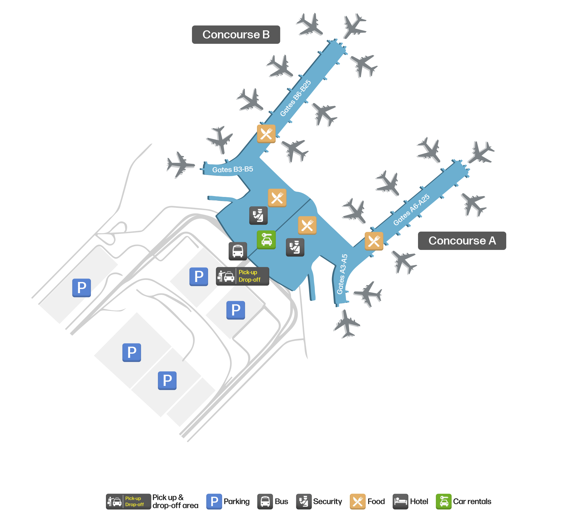
Airport map
The map on this page is rendered from OpenStreetMap data: airports with terminal polygons show the terminal buildings, aprons and access roads, while small fields show the airfield outline and runway. Icons for parking, buses, food, hotels and car rentals follow whatever OSM has mapped.
- Full-size view — open the map card on this page to zoom in; the 2000 px original can be downloaded.
- Location map — the interactive map lets you pan and zoom to see the field against the city and road network.
- Schematic — the page also draws a size-based schematic to indicate the airport's scale; it is not the actual layout.
Direct routes
Non-stop destinations, nearest first (OpenFlights route dataset, compiled 2014 — treat as indicative and confirm with the airline):
| Destination | Distance | Main carriers |
|---|---|---|
| O'Hare International Airport (ORD) | ~286 km | American Airlines, United Airlines |
| Detroit Metropolitan Wayne County Airport (DTW) | ~371 km | Delta Air Lines |
| Cleveland Hopkins International Airport (CLE) | ~420 km | United Airlines |
| Frederick W. Smith International Airport (MEM) | ~613 km | Delta Air Lines |
| Charlotte Douglas International Airport (CLT) | ~688 km | American Airlines, US Airways |
| Hartsfield–Jackson Atlanta International Airport (ATL) | ~696 km | Air France, AeroMéxico |
| Toronto Pearson International Airport (YYZ) | ~707 km | Air Canada |
| Kansas City International Airport (MCI) | ~724 km | AirTran Airways, Southwest Airlines |
See the Indianapolis International Airport route map for the full list of 35 non-stop destinations.
Nearby airports
If nothing fits, these nearby fields are worth comparing:
| Airport | Distance |
|---|---|
| Chicago Midway International Airport (MDW) | 261 km |
| O'Hare International Airport (ORD) | 286 km |
| Abraham Lincoln Capital Airport (SPI) | 289 km |
Getting there
The airport: coordinates 39.7173, -86.2944; elevation about 243 m.
Navigate straight to the field:
- Driving / taxi: 高德地图 | 百度地图 | Google Maps
The location map on this page shows the field against the city and road network, and the ground-transport section lists the public transport recorded for it. For driving routes, timetables and parking, rely on the airport's own information.
Size and facilities
Medium-sized airports are regional hubs: one compact terminal, walkable distances and usually faster check-in than a major hub — but with fewer frequencies, so rebooking after a missed flight is harder. Aim for 90–120 minutes before departure.
Terminal plans, check-in locations and ground-transport timetables are published by the airport itself; for detail that must be right on the day, rely on the airport's own information. If something here looks wrong, please tell us via the Contact page and we will check it.
Tips
- If your destination is not in the table above, you will usually connect via O'Hare International Airport (ORD) or another larger airport.
- Use the search box at the top of the page to compare alternatives: type a city name or IATA code.
- In peak season parking and rental cars run short at small fields too — book ahead if you are driving.
Комментарии читателейОбсуждение
Вопросы, отчёты о поездках и исправления приветствуются. Комментарии видны всем.
Загрузка…
Загрузка комментариев…