
Curitiba-Afonso Pena International Airport
 Curitiba · บราซิล· Curitiba-Afonso Pena International Airport
Curitiba-Afonso Pena International Airport (IATA: CWB, ICAO SBCT) เป็นสนามบินขนาดใหญ่ที่ให้บริการCuritiba, บราซิล
Curitiba-Afonso Pena International Airport is a large airport, at an elevation of about 2,988 ft, with scheduled passenger service. This page gathers its location map, airport codes and travel information.
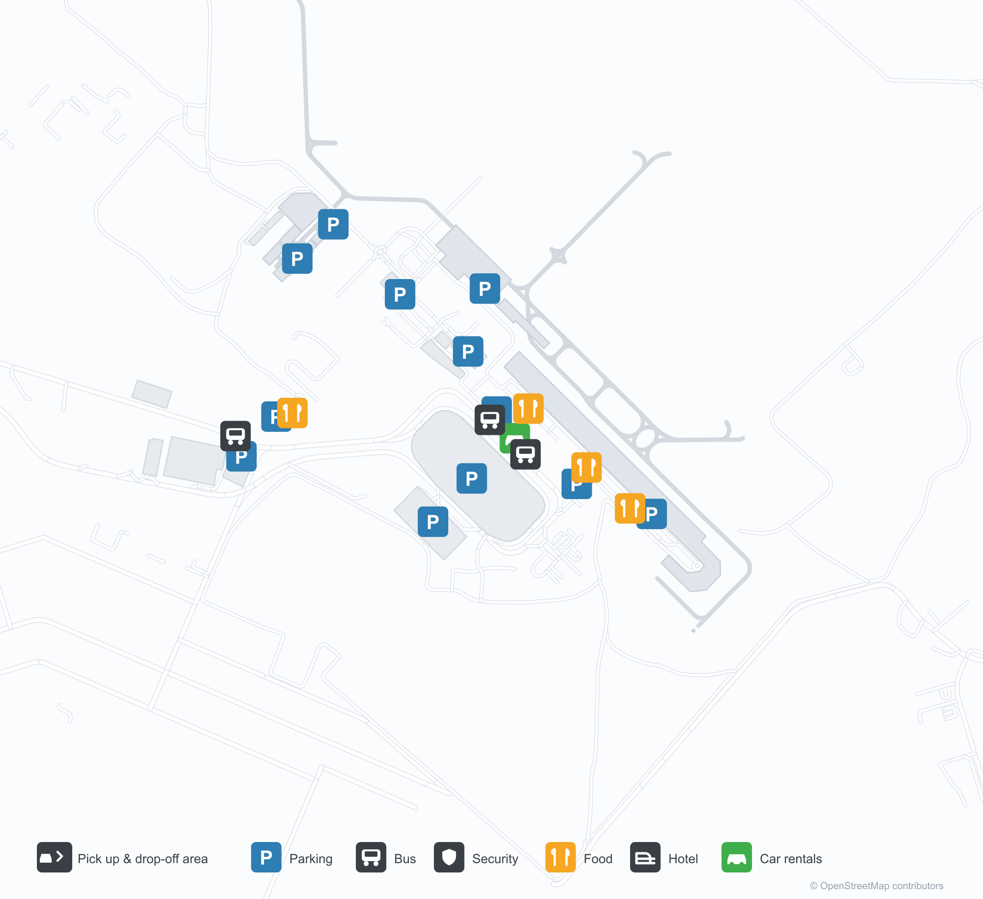
ดาวน์โหลดแผนที่สนามบินดาวน์โหลด
ภาพสนามบินภาพสนามบิน
ภาพจริงของสนามบินแห่งนี้ พร้อมเครดิตของหน้าเว็บสาธารณะที่พบภาพ; ลิขสิทธิ์ยังเป็นของผู้ถ่ายภาพต้นฉบับ คลิกที่ภาพเพื่อขยาย หรือคลิกบรรทัดเครดิตเพื่อเปิดหน้าแหล่งที่มา
เครื่องบินโบอิง 737 ของกองทัพอากาศบราซิลไต่ขึ้นจากทางวิ่งของกูรีชีบา
เครื่องบิน Tu-154 กำลังขับเคลื่อนเข้ามา เห็นเครื่องยนต์สามเครื่อง — เป็นผู้มาเยือนหายากที่ดึงดูดนักถ่ายภาพมาที่กูรีชีบา
ภายใต้ท้องฟ้าสีฟ้าใส ป้ายยาวสีฟ้าที่เขียนชื่อเต็มของสนามบินทอดอยู่ใต้หลังคาอาคารผู้โดยสารเหนือสนามหญ้าที่ตัดเรียบ
มองจากที่สูง อาคารผู้โดยสารและลานจอดรถที่แผ่กว้างเต็มไปด้วยรถยนต์ โดยมีทางวิ่งและเมืองกว้างอยู่ไกลออกไปใต้เมฆ
มองจากอากาศ แถวเครื่องบินโดยสารจอดอยู่ที่ประตูอาคารผู้โดยสาร มีเกาะหญ้าทรงรีสองแห่งฝังอยู่ในพื้นปูข้างทางวิ่ง
เครื่องบินเจ็ตจอดหันจมูกเข้าสะพานเชื่อม โดยมีรถลากเครื่องบินสีเหลืองดำอยู่ด้านล่างและกรวยสีส้มกระจายทั่วลานจอดที่เปียก
ภาพถ่ายทางอากาศแสดงสะพานเชื่อมของอาคารผู้โดยสารเรียงเป็นแถว เครื่องบินโดยสารหางสีแดงที่ช่องจอด และทางวิ่งบรรจบทางขับข้ามสนามหญ้าสีเขียว
ตัวอักษรสีฟ้าพาดตามชายหลังคาของอาคารผู้โดยสารเหนือลานจอดรถที่มีหลังคากันแดดสีฟ้าให้ร่มเงา โดยมีป้ายบอกทางรถเช่าตั้งอยู่ที่ขอบถนน
ภาพถ่ายทางอากาศจากด้านบนแสดงอากาศยานสองลำที่ทางเดินแยกของอาคารผู้โดยสาร ลานจอดรถวงแหวนที่เต็มไปด้วยรถ และเครื่องบินเจ็ตกำลังแตะพื้นทางวิ่ง
แผนที่เส้นทาง Curitiba-Afonso Pena International Airport — จุดหมายบินตรงแผนที่เส้นทาง
21 จุดหมายบินตรง: แผนที่ สายการบินที่ให้บริการ และระยะทาง
เที่ยวบินของCuritiba-Afonso Pena International Airport — ขาออกและขาเข้าป้ายเที่ยวบิน
1,336 หมายเลขเที่ยวบิน ครอบคลุม 31 สายการบิน และ 25 จุดหมายปลายทาง แยกตามทิศทาง หมายเลขเที่ยวบินร่วม (codeshare) รวมอยู่ด้วย
| เที่ยวบิน | สายการบิน | จุดหมายปลายทาง | ประเทศ/ภูมิภาค |
|---|---|---|---|
| AA7652 | American Airlines | ท่าอากาศยานนานาชาติเซาเปาลู/กวารุลยอส | บราซิล |
| AA7653 | American Airlines | ท่าอากาศยานนานาชาติเซาเปาลู/กวารุลยอส | บราซิล |
| AA7732 | American Airlines | Rio de Janeiro Galeão – Tom Jobim International Airport | บราซิล |
| AA7737 | American Airlines | ท่าอากาศยานนานาชาติเซาเปาลู/กวารุลยอส | บราซิล |
| AC6503 | Air Canada | ท่าอากาศยานนานาชาติเซาเปาลู/กวารุลยอส | บราซิล |
| AC6509 | Air Canada | Rio de Janeiro Galeão – Tom Jobim International Airport | บราซิล |
| AC9803 | Air Canada | ท่าอากาศยานนานาชาติเซาเปาลู/กวารุลยอส | บราซิล |
| AC9872 | Air Canada | Rio de Janeiro Galeão – Tom Jobim International Airport | บราซิล |
| AD2223 | Azul Brazilian Airlines | Maceió (MCZ) Zumbi dos Palmares International Airport | บราซิล |
| AD2360 | Azul Brazilian Airlines | Recife (REC) Recife/Guararapes - Gilberto Freyre International Airport | บราซิล |
| AD2366 | Azul Brazilian Airlines | Natal (NAT) Rio Grande do Norte/São Gonçalo do Amarante–Governador Aluízio Alves International Airport | บราซิล |
| AD2600 | Azul Brazilian Airlines | Foz do Iguaçu (IGU) Cataratas International Airport | บราซิล |
| AD2671 | Azul Brazilian Airlines | Tancredo Neves International Airport | บราซิล |
| AD2720 | Azul Brazilian Airlines | Londrina (LDB) Governor José Richa Airport | บราซิล |
| AD2722 | Azul Brazilian Airlines | PTO | |
| AD2734 | Azul Brazilian Airlines | ท่าอากาศยานนานาชาติเซาเปาลู/กวารุลยอส | บราซิล |
| AD2746 | Azul Brazilian Airlines | Porto Alegre (POA) Porto Alegre-Salgado Filho International Airport | บราซิล |
| AD2753 | Azul Brazilian Airlines | Viracopos International Airport | บราซิล |
| AD2773 | Azul Brazilian Airlines | Viracopos International Airport | บราซิล |
| AD2785 | Azul Brazilian Airlines | Rio de Janeiro Galeão – Tom Jobim International Airport | บราซิล |
หมายเลขเที่ยวบินและเส้นทางจากดัชนีเที่ยวบิน aviability.com (ข้อมูล ณ วันที่ 26 ตุลาคม 2569); รวมหมายเลขเที่ยวบินร่วมและไม่แสดงเวลาเดินทาง ที่มา: aviability.com ↗
ข้อมูลและรายละเอียดสนามบินรายละเอียดสนามบิน
แผนที่อินเทอร์แอกทีฟ — ตำแหน่ง Curitiba-Afonso Pena International Airportแผนที่อินเทอร์แอกทีฟ
ดูสนามบินนี้บนบริการแผนที่อื่น:
Curitiba Airport (CWB): Aviation Photography and a Brazilian Domestic Networkคู่มือสนามบิน
Neither photo of Curitiba-Afonso Pena International Airport (IATA CWB, ICAO SBCT) shows the terminal. One catches a Brazilian Air Force Boeing 737 climbing away from the runway; the other frames a Tu-154 taxiing head-on, its three engines lined up. For aviation photographers, the airport's reputation for rare visitors can be more compelling than its building. The flight data, meanwhile, shows a network that is overwhelmingly Brazilian.
The field serves Curitiba in southern Brazil at an elevation of about 911 m, with runways of 2,218 m and 1,798 m. The 2014 route snapshot records 21 non-stop destinations: 18 in Brazil and 3 abroad.
Airport photos
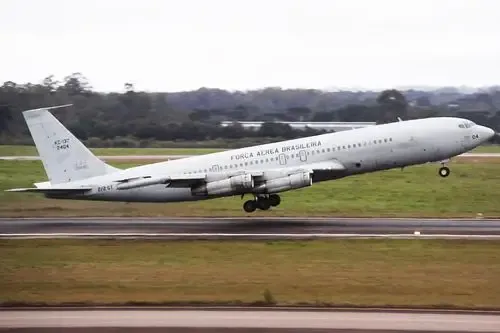
A Brazilian Air Force Boeing 737 climbing away from Curitiba's runway.

A Tu-154 taxiing head-on, its three engines in view — the kind of rare visitor that draws spotters to Curitiba.
The photos come from public web sources and remain the copyright of their photographers; full credits and source links sit in the photo gallery on this page.
Airport at a glance
| Item | Detail |
|---|---|
| IATA / ICAO | CWB / SBCT |
| Role | Large airport and regional hub for southern Brazil |
| Elevation | about 911 m |
| Coordinates | -25.5285, -49.1758 |
| Runways | 2: 15/33 at 2,218 m, 11/29 at 1,798 m |
| Non-stop destinations | 21 (18 domestic, 3 international; 2014 snapshot) |
| Official site | ccraeroportos.com.br/curitiba-pr |
Network shape: 18 domestic routes, the longest to Salvador
By distance: 16 destinations within 1,000 km, 5 between 1,000 and 3,000 km, and none beyond 3,000 km. The near layer is Florianópolis (246 km), Londrina (314 km) and São Paulo Congonhas (331 km). The far layer is Salvador (1,806 km), Buenos Aires Ezeiza (1,369 km) and Aeroparque (1,340 km). This is a Brazilian south–southeast domestic map with a handful of South American neighbours attached.
| Distance band | Destinations |
|---|---|
| Under 1,000 km | 16 |
| 1,000–3,000 km | 5 |
| Over 3,000 km | 0 |
Azul and Sky Express each appear on 10 routes, with TAM Brazilian Airlines on 8. The carrier column includes codeshares, so the figures describe concentration. The full list is on the Curitiba route map.
Getting there and navigating
- Coordinates: -25.5285, -49.1758
- Official site: ccraeroportos.com.br/curitiba-pr
- Open in a map: Google Maps | Amap | Baidu Maps
If the destination needs a fuller domestic or international network, São Paulo Guarulhos (GRU) is the nearest alternative in the snapshot: about 360 km away with 89 destinations. Curitiba itself is built for short domestic hops, so connecting through São Paulo is often the smoother long-distance option.
The location map on this page shows the field against Curitiba and the road network. Terminal connections and local transport fall outside this dataset; the airport or airline can confirm them.
Before you fly
- Allow 90–120 minutes for a domestic departure. At about 911 m the altitude is far from high-altitude territory, but summer heat can still affect take-off performance.
- The 21 destinations are a 2014 snapshot. Brazil's domestic market changes quickly, so check the airline's current schedule.
- If you are visiting specifically to photograph aircraft, confirm the airport's rules on spotting locations first. The Tu-154 and military 737 are irregular visitors, not daily scheduled types.
About the data
Runways, elevation and coordinates come from OurAirports open data. Routes and carriers come from the June 2014 OpenFlights snapshot and include codeshares and interline services; they indicate network shape and scale, not current schedules. Photos are from public web sources and remain the copyright of their photographers.
ความคิดเห็นจากผู้อ่านการสนทนา
ยินดีรับคำถาม รายงานการเดินทาง และการแก้ไข ความคิดเห็นเป็นสาธารณะ
กำลังโหลด…
กำลังโหลดความคิดเห็น…