
Appleton International Airport
 Appleton · สหรัฐอเมริกา· Appleton International Airport
Appleton International Airport (IATA: ATW, ICAO KATW) เป็นสนามบินขนาดกลางที่ให้บริการAppleton, สหรัฐอเมริกา
Appleton International Airport is a medium-sized airport, at an elevation of about 918 ft, with scheduled passenger service. This page gathers its location map, airport codes and travel information.
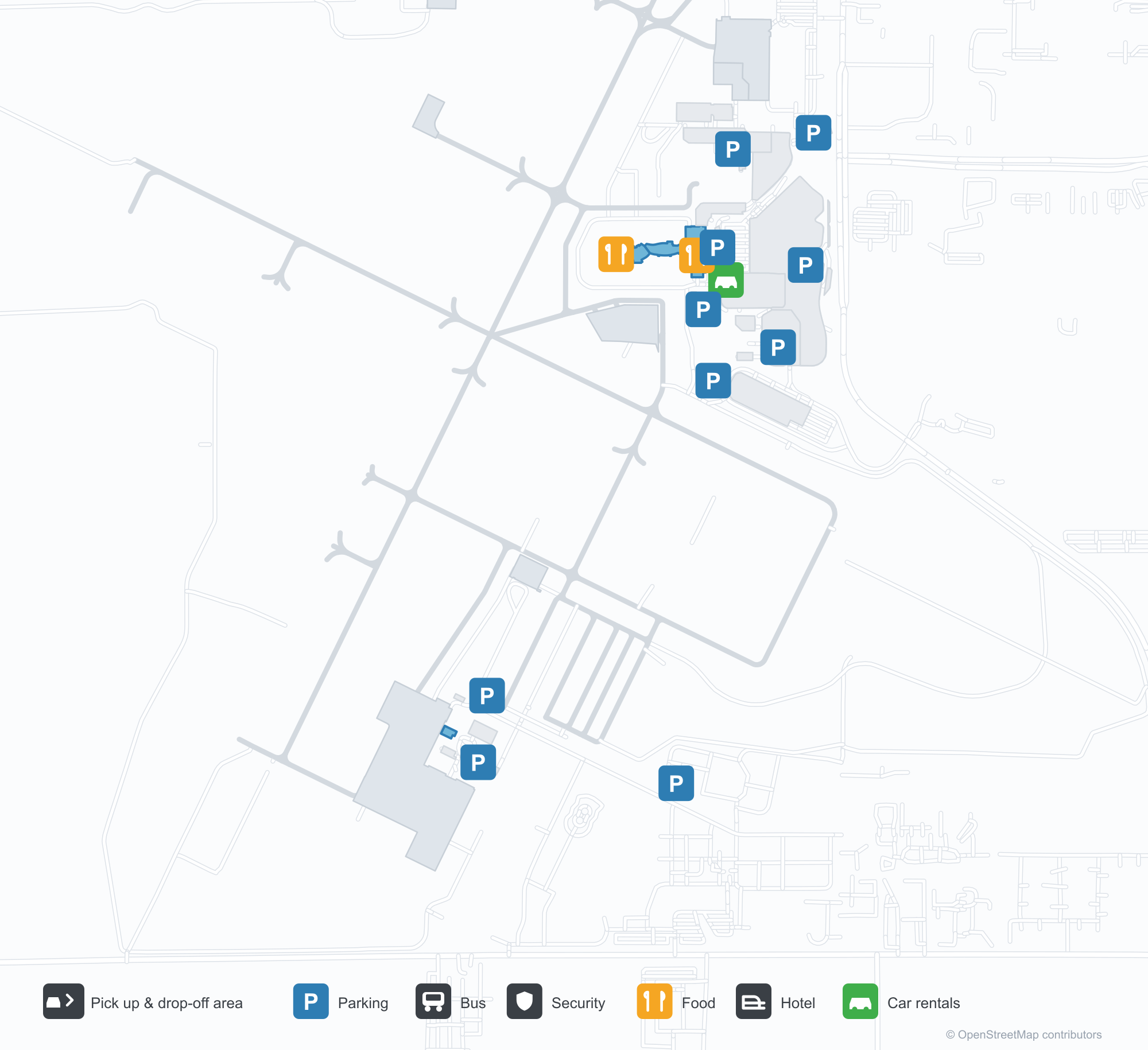
ดาวน์โหลดแผนที่สนามบินดาวน์โหลด
ภาพสนามบินภาพสนามบิน
ภาพจริงของสนามบินแห่งนี้ พร้อมเครดิตของหน้าเว็บสาธารณะที่พบภาพ; ลิขสิทธิ์ยังเป็นของผู้ถ่ายภาพต้นฉบับ คลิกที่ภาพเพื่อขยาย หรือคลิกบรรทัดเครดิตเพื่อเปิดหน้าแหล่งที่มา
ภาพถ่ายดาวเทียม: ทางวิ่งสองเส้นตัดกันระหว่างพื้นที่เกษตรกรรมและตัวเมือง โดยมีอาคารผู้โดยสารและลานจอดอยู่กลางสนามบิน
ใต้หลังคากันแดดโค้ง ป้ายเหนือทางเขียนว่า Appleton International Airport โดยมีเสาอิฐและประตูกระจกนำเข้าสู่โถง
ในวันฟ้าใส เครื่องบินโดยสารสีน้ำเงินส้มสามลำจอดเคียงกันที่สะพานเชื่อม โดยมีแผงโซลาร์บนหลังคาอาคารผู้โดยสารและทางขับอยู่ไกลออกไป
เครื่องบินเจ็ตภูมิภาคสองเครื่องยนต์ American Eagle เร่งความเร็วตามทางวิ่งผ่านหญ้าสูง หางลายสีแดง ขาว และน้ำเงินภายใต้เมฆคิวมูลัส
ภายในอาคารผู้โดยสาร ผนังกระจกสูงสองชั้นอยู่เหนือพื้นขัดเงาและเพดานโค้ง โดยมีผู้เดินทางเข็นกระเป๋าผ่านเคาน์เตอร์บริการทรงกลม
เสาธงสามต้นตั้งอยู่ข้างถนนหน้าอาคารผู้โดยสาร ซึ่งหลังคากันแดดทางเข้ามืดภายใต้ท้องฟ้าใส โดยมีหอบังคับการบินอยู่ทางซ้าย
หลังพระอาทิตย์ตก เครื่องบินเจ็ตภูมิภาคสองลำในสี United รออยู่ที่สะพานเชื่อม ขณะที่หอบังคับการบินและแสงเรืองรองเหนือสนามบินจางหายเป็นเงา
แถวที่นั่งสีเทาอยู่ใต้เพดานไม้โค้งในเลานจ์ประตูขึ้นเครื่อง ที่เจ้าหน้าที่คนหนึ่งเข็นรถทำความสะอาดผ่านหน้าต่างที่มองไปยังลานจอด
แผนที่เส้นทาง Appleton International Airport — จุดหมายบินตรงแผนที่เส้นทาง
7 จุดหมายบินตรง: แผนที่ สายการบินที่ให้บริการ และระยะทาง
เที่ยวบินของAppleton International Airport — ขาออกและขาเข้าป้ายเที่ยวบิน
713 หมายเลขเที่ยวบิน ครอบคลุม 17 สายการบิน และ 19 จุดหมายปลายทาง แยกตามทิศทาง หมายเลขเที่ยวบินร่วม (codeshare) รวมอยู่ด้วย
| เที่ยวบิน | สายการบิน | จุดหมายปลายทาง | ประเทศ/ภูมิภาค |
|---|---|---|---|
| AA3335 | American Airlines | ท่าอากาศยานนานาชาติโอแฮร์ | สหรัฐอเมริกา |
| AA3337 | American Airlines | ท่าอากาศยานนานาชาติโอแฮร์ | สหรัฐอเมริกา |
| AA3340 | American Airlines | ท่าอากาศยานนานาชาติโอแฮร์ | สหรัฐอเมริกา |
| AA3341 | American Airlines | ท่าอากาศยานนานาชาติโอแฮร์ | สหรัฐอเมริกา |
| AA3344 | American Airlines | ท่าอากาศยานนานาชาติโอแฮร์ | สหรัฐอเมริกา |
| AA3429 | American Airlines | ท่าอากาศยานนานาชาติโอแฮร์ | สหรัฐอเมริกา |
| AA3457 | American Airlines | ท่าอากาศยานนานาชาติโอแฮร์ | สหรัฐอเมริกา |
| AA3475 | American Airlines | ท่าอากาศยานนานาชาติโอแฮร์ | สหรัฐอเมริกา |
| AA3515 | American Airlines | ท่าอากาศยานนานาชาติโอแฮร์ | สหรัฐอเมริกา |
| AA3550 | American Airlines | ท่าอากาศยานนานาชาติโอแฮร์ | สหรัฐอเมริกา |
| AA3721 | American Airlines | ท่าอากาศยานนานาชาติโอแฮร์ | สหรัฐอเมริกา |
| AA3954 | American Airlines | Dallas Fort Worth International Airport | สหรัฐอเมริกา |
| AA4187 | American Airlines | Dallas Fort Worth International Airport | สหรัฐอเมริกา |
| AA4189 | American Airlines | Dallas Fort Worth International Airport | สหรัฐอเมริกา |
| AA5078 | American Airlines | Charlotte Douglas International Airport | สหรัฐอเมริกา |
| AA5081 | American Airlines | Charlotte Douglas International Airport | สหรัฐอเมริกา |
| AA5143 | American Airlines | Charlotte Douglas International Airport | สหรัฐอเมริกา |
| AA5308 | American Airlines | Charlotte Douglas International Airport | สหรัฐอเมริกา |
| AA5440 | American Airlines | Charlotte Douglas International Airport | สหรัฐอเมริกา |
| AA5516 | American Airlines | Charlotte Douglas International Airport | สหรัฐอเมริกา |
หมายเลขเที่ยวบินและเส้นทางจากดัชนีเที่ยวบิน aviability.com (ข้อมูล ณ วันที่ 26 ตุลาคม 2569); รวมหมายเลขเที่ยวบินร่วมและไม่แสดงเวลาเดินทาง ที่มา: aviability.com ↗
ข้อมูลและรายละเอียดสนามบินรายละเอียดสนามบิน
แผนที่อินเทอร์แอกทีฟ — ตำแหน่ง Appleton International Airportแผนที่อินเทอร์แอกทีฟ
ดูสนามบินนี้บนบริการแผนที่อื่น:
Appleton Airport (ATW): Two Crossing Runways and Seven Domestic Routesคู่มือสนามบิน
Seen from above, two runways cross between farmland and town, with the terminal and apron in the middle of the field and Wisconsin's fields and streets around it. The airport serves Appleton, Wisconsin, at an elevation of about 280 m, with runways of 2,439 m and 1,982 m; the 2014 snapshot records seven domestic destinations, from Chicago at 258 km to Las Vegas at 2,425 km.
Satellite view
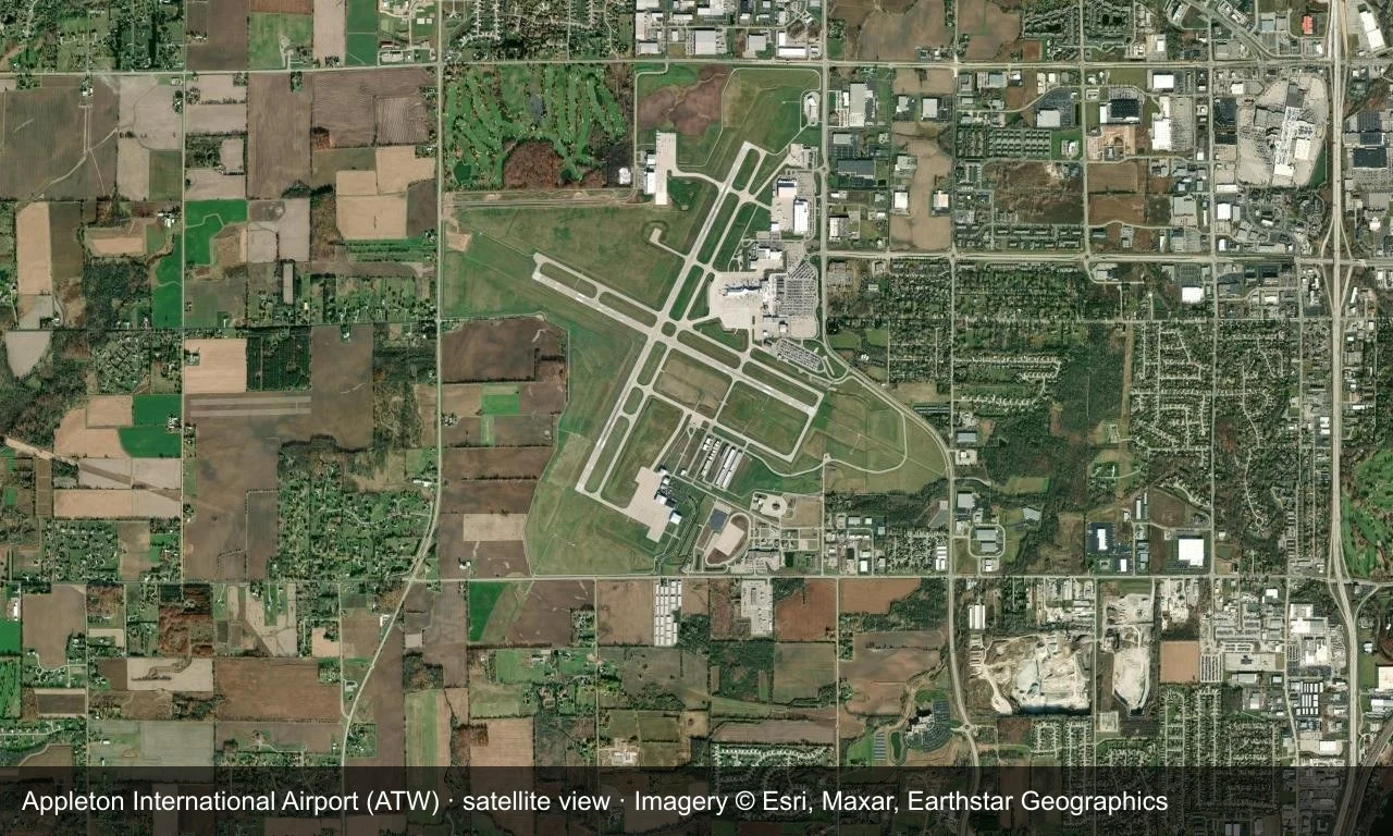
Satellite view: two runways cross between farmland and town, with the terminal and apron in the middle of the field.
The satellite image comes from Esri World Imagery (© Esri, Maxar, Earthstar Geographics); the field and attribution are labelled in the image. This is a satellite view, not a ground-level photograph.
Airport at a glance
| Item | Detail |
|---|---|
| IATA / ICAO | ATW / KATW |
| Role | Medium-sized airport |
| Elevation | about 280 m |
| Coordinates | 44.2585, -88.5190 |
| Runways | 2, longest 2,439 m |
| Non-stop destinations | 7 (2014 snapshot, all domestic US) |
| Official site | www.atwairport.com |
Runways
| Runway | Length | Width | Surface |
|---|---|---|---|
| 03/21 | 2,439 m | 46 m | concrete |
| 12/30 | 1,982 m | 46 m | concrete |
2 runways, the longest 2,439 m.
Non-stop routes
7 non-stop destinations, nearest first (OpenFlights route snapshot compiled in 2014 — confirm with the airline or airport):
| Destination | Distance | Carriers |
|---|---|---|
| Chicago O'Hare International Airport (ORD) | ~258 km | United Airlines |
| Minneapolis–Saint Paul International Airport / Wold–Chamberlain Field (MSP) | ~379 km | Delta Air Lines |
| Detroit Metropolitan Wayne County Airport (DTW) | ~476 km | Delta Air Lines |
| Hartsfield Jackson Atlanta International Airport (ATL) | ~1232 km | Air France, Delta Air Lines, KLM Royal Dutch Airlines |
| Orlando Sanford International Airport (SFB) | ~1839 km | Allegiant Air |
| Mesa Gateway Airport (AZA) | ~2334 km | Allegiant Air |
| Harry Reid International Airport (LAS) | ~2425 km | Allegiant Air |
The carrier column comes from the same snapshot and includes codeshare and interline services; treat it as an indication of how busy the route is and check the airline for who actually flies it.
Nearby airports to compare
If the fares are close, these are the nearest airports of the same class (medium-sized airport) — straight-line distance, with their own non-stop counts from the same dataset:
| Airport | Distance | Non-stop destinations |
|---|---|---|
| Austin Straubel International Airport (GRB) | ~40 km | 4 |
| Alpena County Regional Airport (APN) | ~403 km | 2 |
Before you fly
- Allow 90–120 minutes for a domestic departure; Allegiant's leisure routes are seasonal, so confirm the schedule.
- The seven destinations are a 2014 snapshot and the network has changed; Chicago and Minneapolis are the main connection fallbacks.
About the data
Runways, elevation and coordinates come from OurAirports open data. Routes and carriers come from the June 2014 OpenFlights snapshot and include codeshares and interline services; they indicate network shape and scale, not current schedules.
ความคิดเห็นจากผู้อ่านการสนทนา
ยินดีรับคำถาม รายงานการเดินทาง และการแก้ไข ความคิดเห็นเป็นสาธารณะ
กำลังโหลด…
กำลังโหลดความคิดเห็น…