
Albuquerque International Sunport
 Albuquerque · สหรัฐอเมริกา· Albuquerque International Sunport
Albuquerque International Sunport (IATA: ABQ, ICAO KABQ) เป็นสนามบินขนาดใหญ่ที่ให้บริการAlbuquerque, สหรัฐอเมริกา
Albuquerque International Sunport is a large airport, at an elevation of about 5,355 ft, with scheduled passenger service. This page gathers its location map, airport codes and travel information.
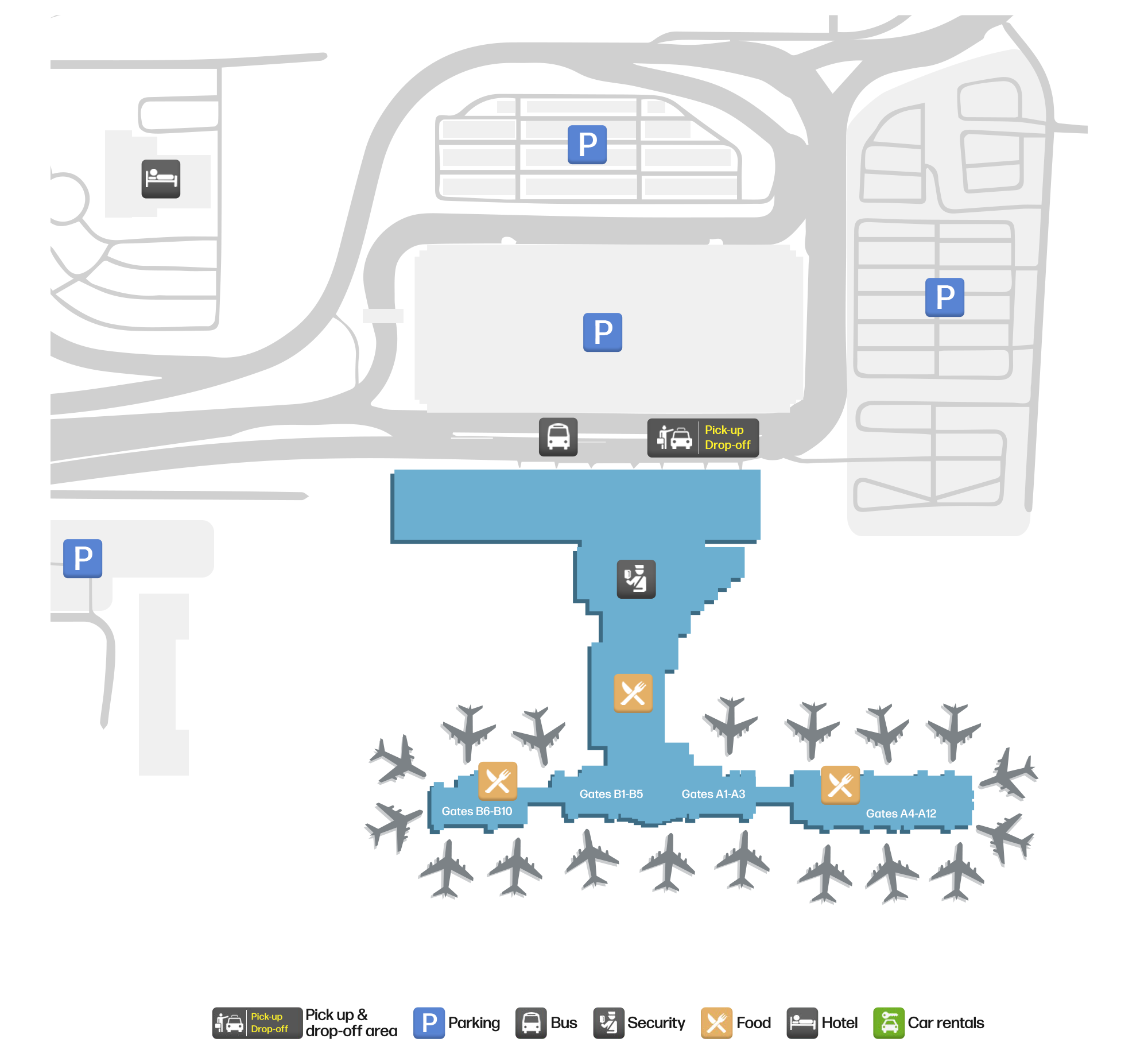
ดาวน์โหลดแผนที่สนามบินดาวน์โหลด
ภาพสนามบินภาพสนามบิน
ภาพจริงของสนามบินแห่งนี้ พร้อมเครดิตของหน้าเว็บสาธารณะที่พบภาพ; ลิขสิทธิ์ยังเป็นของผู้ถ่ายภาพต้นฉบับ คลิกที่ภาพเพื่อขยาย หรือคลิกบรรทัดเครดิตเพื่อเปิดหน้าแหล่งที่มา
ซันพอร์ต (Sunport) ในช่วงโกลเดนอาวร์: อาคารผู้โดยสารอยู่หลังแถวโครงสร้างและช่องจอดรถ โดยมีเส้นขอบฟ้าของแอลบูเคอร์คีและหน้าผาทะเลทรายอยู่เบื้องหลัง
ภาพถ่ายทางอากาศของอาคารผู้โดยสารและลานจอด: โถงสไตล์พูเอโบลสีชมพูเชื่อมสู่ลานจอดด้วยสะพานเชื่อม มีอากาศยานจอดที่ประตู อาคารจอดรถและตัวเมืองอยู่ด้านหลัง
ยามพลบค่ำ ถนนขอบทางยกระดับของอาคารผู้โดยสารมีรถรับส่งและรถยนต์จอดอยู่ใต้หลังคากันแดดสีเขียวอมฟ้า โดยมีเมฆพัดผ่านเหนืออาคารสีดินเผา
มองจากที่สูง แผงโซลาร์เซลล์มุงหลังคาอาคารจอดรถ ขณะที่โถงสีชมพูอ่อนแผ่ขยายไปทั่วลานจอด โดยมีอากาศยานจอดอยู่ทั้งสองปลาย
ภาพหน้าจอที่มีแถบชื่อเรื่องสีฟ้าแสดงภาพทางอากาศของทางวิ่งและอาคารผู้โดยสาร โดยมีตารางถนนของเมืองทอดไปสู่ภูเขาที่มีหิมะเป็นลาย
หลังมืด ด้านหน้าอาคารผู้โดยสารสว่างด้วยแสงไฟโทนอุ่น ขณะที่แถบไฟสีเทอร์ควอยซ์ลากตามหลังคากันแดดเหนือถนนที่ว่างเปล่า
มองจากด้านข้าง เครื่องบินเจ็ตจอดอยู่ที่สะพานเชื่อม ขณะที่โรงจอดรถหลังคาโซลาร์และแถวรถยนต์เต็มพื้นที่ฉากหน้า
ภาพถ่ายเก่าที่จางลงของสนามบิน: รถยนต์แน่นลานจอดหน้าอาคารผู้โดยสารอิฐ และมีเครื่องบินโดยสารรออยู่บนลานจอด
แผนที่เส้นทาง Albuquerque International Sunport — จุดหมายบินตรงแผนที่เส้นทาง
22 จุดหมายบินตรง: แผนที่ สายการบินที่ให้บริการ และระยะทาง
เที่ยวบินของAlbuquerque International Sunport — ขาออกและขาเข้าป้ายเที่ยวบิน
1,783 หมายเลขเที่ยวบิน ครอบคลุม 40 สายการบิน และ 31 จุดหมายปลายทาง แยกตามทิศทาง หมายเลขเที่ยวบินร่วม (codeshare) รวมอยู่ด้วย
| เที่ยวบิน | สายการบิน | จุดหมายปลายทาง | ประเทศ/ภูมิภาค |
|---|---|---|---|
| AA9 | American Airlines | Dallas Fort Worth International Airport | สหรัฐอเมริกา |
| AA99 | American Airlines | Dallas Fort Worth International Airport | สหรัฐอเมริกา |
| AA709 | American Airlines | Dallas Fort Worth International Airport | สหรัฐอเมริกา |
| AA712 | American Airlines | Dallas Fort Worth International Airport | สหรัฐอเมริกา |
| AA999 | American Airlines | Dallas Fort Worth International Airport | สหรัฐอเมริกา |
| AA1027 | American Airlines | Phoenix Sky Harbor International Airport | สหรัฐอเมริกา |
| AA1048 | American Airlines | Phoenix Sky Harbor International Airport | สหรัฐอเมริกา |
| AA1121 | American Airlines | Dallas Fort Worth International Airport | สหรัฐอเมริกา |
| AA1193 | American Airlines | ท่าอากาศยานนานาชาติโอแฮร์ | สหรัฐอเมริกา |
| AA1219 | American Airlines | ท่าอากาศยานนานาชาติโอแฮร์ | สหรัฐอเมริกา |
| AA1231 | American Airlines | Dallas Fort Worth International Airport | สหรัฐอเมริกา |
| AA1480 | American Airlines | Phoenix Sky Harbor International Airport | สหรัฐอเมริกา |
| AA1546 | American Airlines | Dallas Fort Worth International Airport | สหรัฐอเมริกา |
| AA1844 | American Airlines | Phoenix Sky Harbor International Airport | สหรัฐอเมริกา |
| AA1912 | American Airlines | Dallas Fort Worth International Airport | สหรัฐอเมริกา |
| AA1917 | American Airlines | Phoenix Sky Harbor International Airport | สหรัฐอเมริกา |
| AA1929 | American Airlines | Phoenix Sky Harbor International Airport | สหรัฐอเมริกา |
| AA2115 | American Airlines | ท่าอากาศยานนานาชาติโอแฮร์ | สหรัฐอเมริกา |
| AA2156 | American Airlines | ท่าอากาศยานนานาชาติโอแฮร์ | สหรัฐอเมริกา |
| AA2245 | American Airlines | ท่าอากาศยานนานาชาติโอแฮร์ | สหรัฐอเมริกา |
หมายเลขเที่ยวบินและเส้นทางจากดัชนีเที่ยวบิน aviability.com (ข้อมูล ณ วันที่ 26 ตุลาคม 2569); รวมหมายเลขเที่ยวบินร่วมและไม่แสดงเวลาเดินทาง ที่มา: aviability.com ↗
ข้อมูลและรายละเอียดสนามบินรายละเอียดสนามบิน
แผนที่อินเทอร์แอกทีฟ — ตำแหน่ง Albuquerque International Sunportแผนที่อินเทอร์แอกทีฟ
ดูสนามบินนี้บนบริการแผนที่อื่น:
Albuquerque Sunport (ABQ): A Desert Airport at 1,632 mคู่มือสนามบิน
Albuquerque International Sunport (IATA ABQ, ICAO KABQ) is hard to confuse with any other US airport. In the photos, the terracotta Pueblo-Revival terminal glows with the word "ALBUQUERQUE" above the roadway; from the air, pink Pueblo-style concourses reach the apron on jet bridges, with parking decks, the city skyline and a desert escarpment behind. The dusk shot makes another point: this is an airport surrounded by open country and distant ridges, not a hub wedged into dense city blocks.
The field serves Albuquerque, New Mexico, at an elevation of about 1,632 m — one of the higher airports in this directory. The 2014 route snapshot records 22 non-stop destinations, all within the United States.
Airport photos
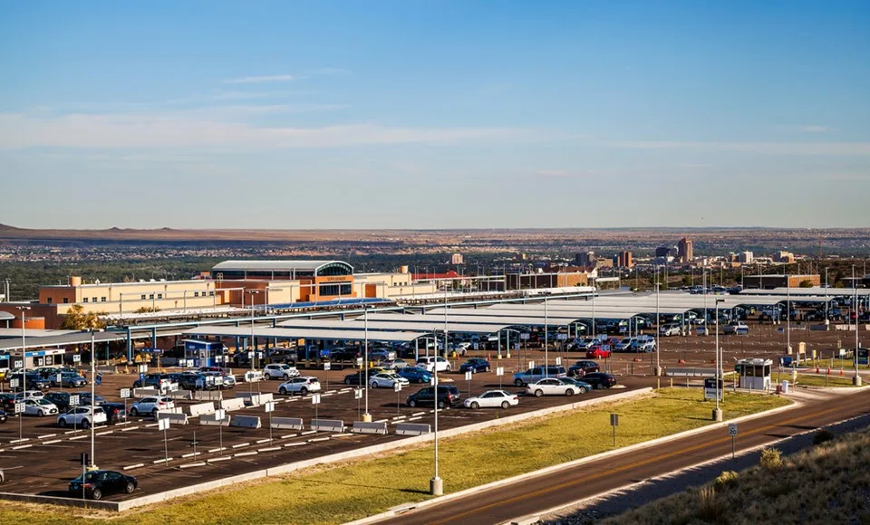
Sunport at golden hour: the terminal sits behind rows of parking structures and stalls, with Albuquerque's skyline and the desert escarpment beyond.
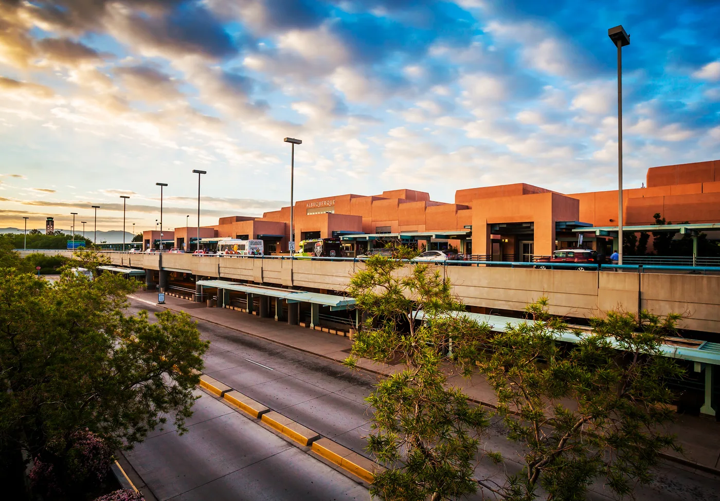
The landside face of the terminal — 'ALBUQUERQUE' glowing on the Pueblo-Revival terracotta blocks, with shuttles and cars on the roadway below.
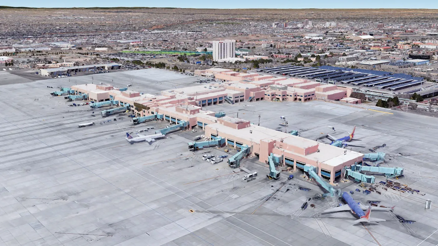
Aerial of the terminal and apron: pink Pueblo-style concourses linking to the ramp through jet bridges, aircraft parked at the gates, parking decks and the city behind.
The photos come from public web sources and remain the copyright of their photographers; full credits and source links sit in the photo gallery on this page.
Airport at a glance
| Item | Detail |
|---|---|
| IATA / ICAO | ABQ / KABQ |
| Role | Large airport and regional gateway for the US Southwest |
| Elevation | about 1,632 m |
| Coordinates | 35.0400, -106.6089 |
| Runways | 3: 08/26 at 4,204 m, 03/21 at 3,048 m, 12/30 at 1,829 m |
| Non-stop destinations | 22 (2014 snapshot, all domestic US) |
| Official site | abqsunport.com |
Why the longest runway is 4,204 m
Of ABQ's three runways, 08/26 is 4,204 m — far longer than the other two. High elevation thins the air, and desert heat thins it further, reducing engine thrust and wing lift; the same aircraft therefore needs a longer runway for take-off and landing. An elevation of 1,632 m in a desert climate explains why this runway exists.
It also shapes the airport's character: the field can handle narrowbodies and widebodies arriving from a long way out, yet all 22 destinations in the 2014 snapshot are domestic. ABQ is a US Southwest domestic network rather than an international gateway.
Network shape: 22 destinations, all in the United States
By distance, 7 destinations are within 1,000 km and 15 between 1,000 and 3,000 km; none are farther. The nearest are Cavern City (CNM, 371 km), Phoenix (527 km) and Denver (562 km). The farthest are Atlanta (2,038 km), Baltimore (2,682 km) and New York JFK (2,931 km).
| Distance band | Destinations |
|---|---|
| Under 1,000 km | 7 |
| 1,000–3,000 km | 15 |
| Over 3,000 km | 0 |
Southwest Airlines appears on 13 of the routes, followed by AirTran, United, American and US Airways. The carrier column includes codeshares, so these numbers describe network concentration. The full list is on the Albuquerque route map.
Getting there and navigating
- Coordinates: 35.0400, -106.6089
- Official site: abqsunport.com
- Open in a map: Google Maps | Amap | Baidu Maps
If fares are close, compare the nearby airports in the snapshot: Ciudad Juárez (CJS) is about 379 km away with 6 destinations, and Oklahoma City (OKC) about 819 km away with 20. CJS can be an option for northern Mexico, but remember the international border formalities.
The location map on this page shows the field against Albuquerque and the surrounding road network. Terminal connections and local transport fall outside this dataset; the airport or airline can confirm them.
Before you fly
- With a mostly domestic network, 90–120 minutes before departure is usually enough; add a buffer for peak season and early-morning departures.
- At 1,632 m and in dry desert air, hydration matters more than at sea level. Summer afternoon storms can also disrupt flights.
- The 22 destinations are a 2014 snapshot. Southwest reshapes its network often, so check the airline's current schedule.
About the data
Runways, elevation and coordinates come from OurAirports open data. Routes and carriers come from the June 2014 OpenFlights snapshot and include codeshares and interline services; they indicate network shape and scale, not current schedules. Photos are from public web sources and remain the copyright of their photographers.
History
Albuquerque's municipal airport opened in 1939 with two paved runways and its Pueblo-style terminal; a year later it became an Army air base, and it still shares its runways with what is now Kirtland Air Force Base.
Source: Albuquerque Intl Sunport Airport.
ความคิดเห็นจากผู้อ่านการสนทนา
ยินดีรับคำถาม รายงานการเดินทาง และการแก้ไข ความคิดเห็นเป็นสาธารณะ
กำลังโหลด…
กำลังโหลดความคิดเห็น…