
Amami Airport
 Amami · Jepang· Amami Airport
Amami Airport (IATA: ASJ, ICAO RJKA) adalah bandara sedang yang melayani Amami, Jepang.
Amami Airport is a medium-sized airport, at an elevation of about 27 ft, with scheduled passenger service. This page gathers its location map, airport codes and travel information.
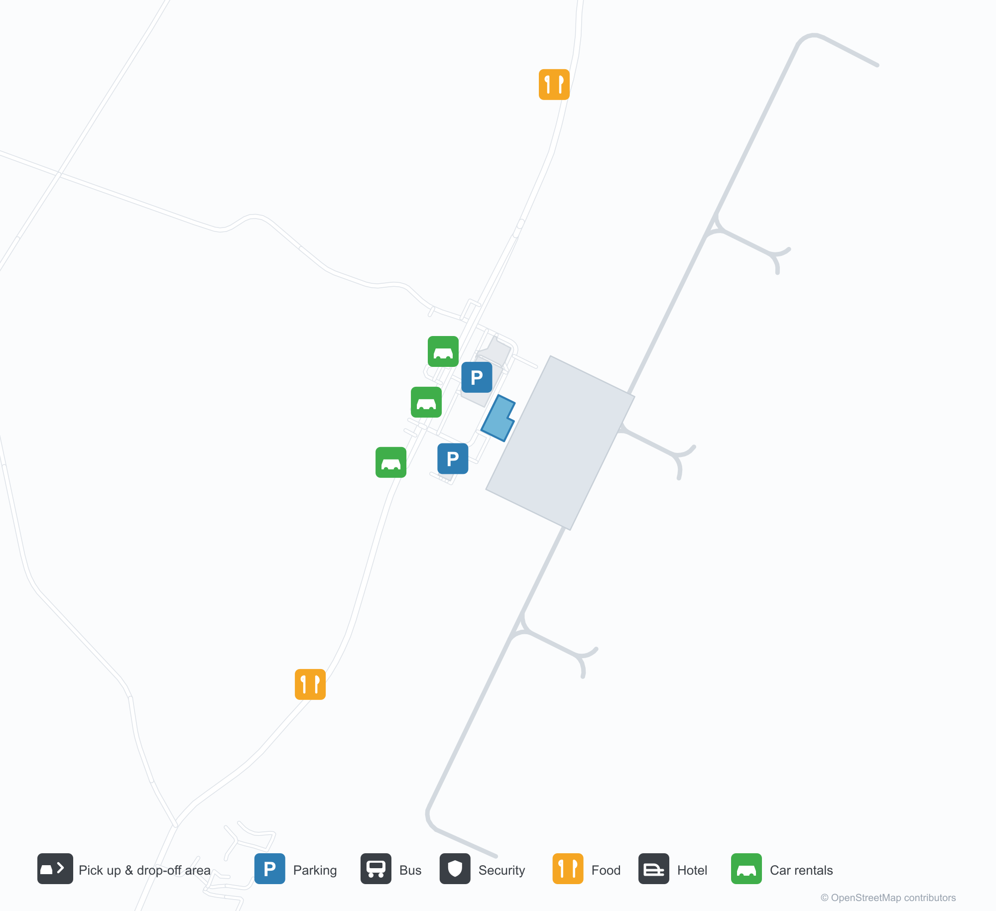
Unduh Peta BandaraUnduhan
Foto bandaraFoto Bandara
Foto asli bandara ini, masing-masing dikreditkan ke halaman web publik tempat foto ditemukan; hak cipta tetap milik fotografer aslinya. Klik foto untuk memperbesar, atau baris kredit untuk membuka halaman sumbernya.
Di apron di depan terminal — penumpang dengan barang bawaan menuju bangunan bertanda 'AMAMI', petugas darat mengarahkan mereka.
Pesawat Japan Air Commuter di stand — dua jet regional menaikkan penumpang di bawah papan, laut tepat di balik landasan pacu.
Amami dari udara — landasan pacu membentang di sepanjang pesisir, air bertabur terumbu terbentang di bawahnya.
Peta rute Amami Airport — tujuan langsungPeta Rute
2 tujuan langsung: peta, maskapai yang beroperasi, dan jarak.
Penerbangan Amami Airport — keberangkatan & kedatanganPapan Penerbangan
63 nomor penerbangan dari 8 maskapai dan 10 tujuan, dipisahkan menurut arah. Nomor codeshare disertakan.
| Penerbangan | Maskapai | Tujuan | Negara/wilayah |
|---|---|---|---|
| AS7958 | Alaska Airlines | Bandara Tokyo Haneda | Jepang |
| BC382 | Skymark Airlines | Kagoshima (KOJ) Kagoshima Airport | Jepang |
| BC388 | Skymark Airlines | Kagoshima (KOJ) Kagoshima Airport | Jepang |
| CI9900 | China Airlines | Kagoshima (KOJ) Kagoshima Airport | Jepang |
| CI9924 | China Airlines | Fukuoka Airport | Jepang |
| JL658 | Japan Airlines | Bandara Tokyo Haneda | Jepang |
| JL2464 | Japan Airlines | Osaka Itami International Airport | Jepang |
| JL2468 | Japan Airlines | Osaka Itami International Airport | Jepang |
| JL3684 | Japan Airlines | Fukuoka Airport | Jepang |
| JL3722 | Japan Airlines | Kagoshima (KOJ) Kagoshima Airport | Jepang |
| JL3724 | Japan Airlines | Kagoshima (KOJ) Kagoshima Airport | Jepang |
| JL3726 | Japan Airlines | Kagoshima (KOJ) Kagoshima Airport | Jepang |
| JL3728 | Japan Airlines | Kagoshima (KOJ) Kagoshima Airport | Jepang |
| JL3730 | Japan Airlines | Kagoshima (KOJ) Kagoshima Airport | Jepang |
| JL3734 | Japan Airlines | Kagoshima (KOJ) Kagoshima Airport | Jepang |
| JL3738 | Japan Airlines | Kagoshima (KOJ) Kagoshima Airport | Jepang |
| JL3831 | Japan Airlines | Kikai (KKX) Kikai Airport | Jepang |
| JL3837 | Japan Airlines | Kikai (KKX) Kikai Airport | Jepang |
| JL3841 | Japan Airlines | Amagi (TKN) Tokunoshima Airport | Jepang |
| JL3843 | Japan Airlines | Amagi (TKN) Tokunoshima Airport | Jepang |
Nomor penerbangan dan rute dari indeks penerbangan aviability.com (cuplikan 26 Oktober 2026); nomor codeshare disertakan dan waktu keberangkatan tidak ditampilkan. Sumber: aviability.com ↗
Informasi & detail bandaraDetail Bandara
Peta interaktif — lokasi Amami AirportPeta Interaktif
Lihat bandara ini di layanan peta lain:
Amami Airport (ASJ): A Coastal Runway and Two Mainland RoutesPanduan Bandara
In one photo, passengers with bags walk towards the terminal marked "AMAMI" while ground crew guide them. Another shows two Japan Air Commuter (JAC) regional aircraft at the stands, the airport pressed against the coastline; from the air, the runway follows the shore with sea and coral visible beneath the wing. The airport serves Amami, Japan, at an elevation of about 8 m, with a 1,999 m runway; the 2014 snapshot records two domestic destinations, Osaka Itami at 890 km and Tokyo Haneda at 1,235 km.
Airport photos
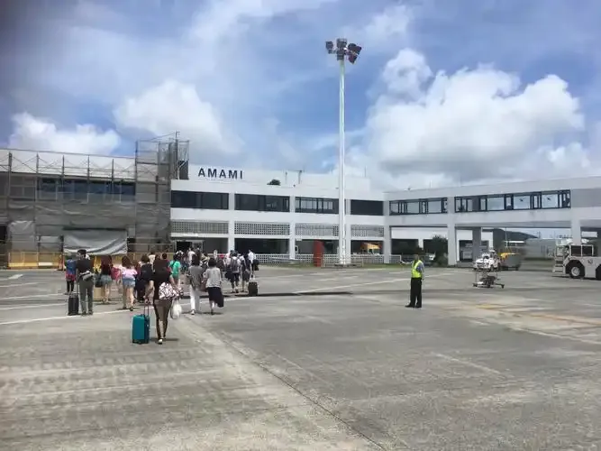
On the apron before the terminal — passengers with luggage heading for the building marked 'AMAMI', ground staff directing them.
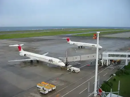
Japan Air Commuter aircraft at the stands — two regional jets boarding beneath the signs, the sea just beyond the runway.
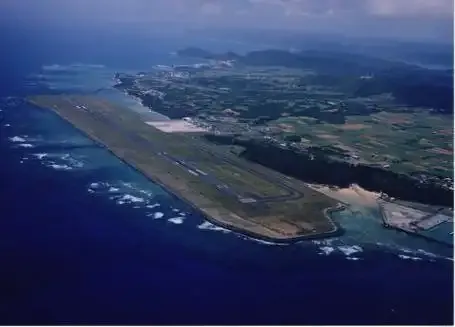
Amami from the air — the runway strung along the coast, reef-flecked water stretching below.
The photos come from public web sources and remain the copyright of their photographers; full credits and source links sit in the photo gallery on this page.
Airport at a glance
| Item | Detail |
|---|---|
| IATA / ICAO | ASJ / RJKA |
| Role | Medium-sized airport |
| Elevation | about 8 m |
| Coordinates | 28.4306, 129.7130 |
| Runways | 1, 1,999 m |
| Non-stop destinations | 2 (2014 snapshot, all domestic) |
Runways
| Runway | Length | Width | Surface |
|---|---|---|---|
| 03/21 | 1,999 m | 46 m | asphalt |
1 runway, the longest 1,999 m.
Non-stop routes
2 non-stop destinations, nearest first (OpenFlights route snapshot compiled in 2014 — confirm with the airline or airport):
| Destination | Distance | Carriers |
|---|---|---|
| Osaka Itami International Airport (ITM) | ~890 km | Japan Airlines Domestic |
| Tokyo Haneda International Airport (HND) | ~1235 km | Japan Airlines Domestic |
The carrier column comes from the same snapshot and includes codeshare and interline services; treat it as an indication of how busy the route is and check the airline for who actually flies it.
Nearby airports to compare
If the fares are close, these are the nearest airports of the same class (medium-sized airport) — straight-line distance, with their own non-stop counts from the same dataset:
| Airport | Distance | Non-stop destinations |
|---|---|---|
| Amakusa Airport (AXJ) | ~453 km | — |
Before you fly
- With two mainland routes, 90–120 minutes is usually enough; typhoon season and coastal wind can affect flights.
- The airport sits by the coast; buses or rental cars handle onward transport, so check connection times before arrival.
About the data
Runways, elevation and coordinates come from OurAirports open data. Routes and carriers come from the June 2014 OpenFlights snapshot and include codeshares and interline services; they indicate network shape and scale, not current schedules.
History
On Amami Ōshima about 22 km from the city, the field was long called Amami Oshima Airport before shortening to its present name; its routes mainly link the island with Kagoshima, Tokyo and Osaka.
Source: Amami Airport.
Komentar pembacaDiskusi
Pertanyaan, laporan perjalanan, dan koreksi sangat kami harapkan. Komentar bersifat publik.
Memuat…
Memuat komentar…