
Araracuara Airport
 Araracuara · Colombia· Araracuara Airport
Araracuara Airport (IATA: ACR, OACI SKAC) es un aeropuerto pequeño que da servicio a Araracuara, Colombia.
Araracuara Airport is a small airport, at an elevation of about 1,250 ft. This page gathers its location map, airport codes and travel information.
Descargar mapas de aeropuertosDescargas
Fotos del aeropuertoFotos del aeropuerto
Fotos reales de este aeropuerto, cada una con la referencia de la página web pública donde se encontró; los derechos de autor siguen siendo de los fotógrafos originales. Haz clic en una foto para ampliarla o en la línea de crédito para abrir su página de origen.
Vista satelital: el Aeropuerto de Araracuara (ACR) está rodeado de vegetación verde y tierras agrícolas.
Información y datos del aeropuertoDatos del aeropuerto
Mapa interactivo — ubicación de Araracuara AirportMapa interactivo
Consulta este aeropuerto en otros servicios de mapas:
Araracuara Airport (ACR) Guide: A route list that stays emptyGuía del aeropuerto
Araracuara Airport (ACR) is a small airport in Colombia, with dense green vegetation and small fields clear around it from above. The field is about 381 m above sea level with runway dimensions that OurAirports does not list; no scheduled routes were recorded in 2014. The closest airport, Fabio Alberto Leon Bentley Airport, lies 317 km away.
Satellite view
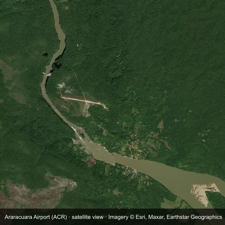
From orbit, Araracuara Airport (ACR) appears as a field within dense green vegetation and small fields.
The image is Esri World Imagery (© Esri, Maxar, Earthstar Geographics), labelled with the field and source. It is a satellite view, not a ground photo.
Airport at a glance
| Item | Detail |
|---|---|
| IATA / ICAO | ACR / SKAC |
| Role | small airport |
| Elevation | about 381 m |
| Coordinates | -0.6009, -72.3980 |
| Runways | Not listed in OurAirports |
| Non-stop destinations | 0 in the 2014 snapshot |
Runways
OurAirports does not list runway dimensions for this airport.
Why there is no route table
This airport's route list is blank in the 2014 snapshot. That may reflect a small or seasonal operation, or simply missing data; confirm before planning a flight.
Nearby airports
| Airport | Distance | Non-stop destinations |
|---|---|---|
| Fabio Alberto Leon Bentley Airport (MVP) | ~317 km | 2 |
| Jorge E. Gonzalez Torres Airport (SJE) | ~355 km | 1 |
| Coronel FAP Francisco Secada Vignetta International Airport (IQT) | ~368 km | 4 |
Getting there and navigating
- Coordinates: -0.6009, -72.3980
- Open in a map: Google Maps | Amap | Baidu Maps
The map on this page shows the airfield and nearby roads. Terminal connections and local transport are not covered here; the operator can confirm them.
Site and data gaps
Araracuara Airport lies in Colombia, with dense green vegetation and small fields around the field. The open dataset does not list runway dimensions. Elevation is about 381 m.
Fabio Alberto Leon Bentley Airport is the nearest airport in the comparison set, 317 km away. No scheduled routes appear in the 2014 snapshot; treat the field as a general-aviation or charter stop and confirm access with the operator.
Before you fly
- Fabio Alberto Leon Bentley Airport is 317 km away with 2 destinations in the 2014 snapshot, making it the nearest alternative for a scheduled flight.
- Because the 2014 route table is empty, check the airport operator's current notices before making travel plans.
- Treat this as a general-aviation or charter field rather than a large terminal; confirm handling and opening hours in advance.
About the data
The airport facts on this page are drawn from OurAirports. Route data is the June 2014 OpenFlights snapshot, so treat it as historical context rather than a timetable.
Comentarios de los lectoresDebate
Las preguntas, los relatos de viaje y las correcciones son bienvenidos. Los comentarios son públicos.
Cargando…
Cargando comentarios…