
Boston Logan International Airport
 Boston · Hoa Kỳ· Boston Logan International Airport
Boston Logan International Airport (IATA: BOS, ICAO KBOS) là một sân bay lớn phục vụ Boston, Hoa Kỳ.
Boston Logan International Airport (BOS) is a large international airport serving Boston, United States. This page gathers the airport codes, location map and travel information.
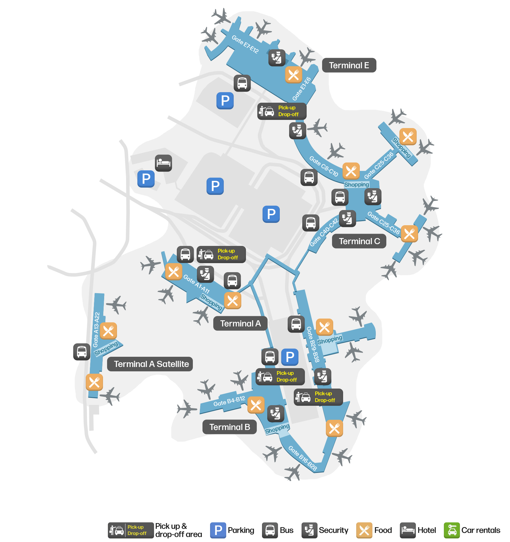
Tải bản đồ sân bayTải xuống
Ảnh sân bayẢnh sân bay
Ảnh thực tế của sân bay này, mỗi ảnh đều ghi nguồn từ trang web công khai nơi tìm thấy ảnh; bản quyền thuộc về nhiếp ảnh gia gốc. Nhấp vào ảnh để phóng to, hoặc nhấp vào dòng ghi nguồn để mở trang nguồn.
Trong ảnh vệ tinh, bố cục của Sân bay Quốc tế Boston Logan (BOS) và khu vực xung quanh hiện rõ.
Bản đồ tuyến bay Boston Logan International Airport — điểm đến thẳngBản đồ tuyến bay
100 điểm đến thẳng: bản đồ, hãng hàng không khai thác và khoảng cách.
Chuyến bay tại Boston Logan International Airport — khởi hành & đếnBảng chuyến bay
9.060 số hiệu chuyến bay của 84 hãng hàng không, kết nối 151 điểm đến, phân theo chiều bay. Bao gồm số hiệu liên danh.
| Chuyến bay | Hãng hàng không | Điểm đến | Quốc gia/khu vực |
|---|---|---|---|
| 2T101 | Bermudair | The Valley (AXA) Clayton J. Lloyd International Airport | Anguilla |
| 2T201 | Bermudair | Providenciales (PLS) Providenciales International Airport | Quần đảo Turks và Caicos |
| 2T301 | Bermudair | Hamilton (BDA) L.F. Wade International Airport | Bermuda |
| 2T302 | Bermudair | Hamilton (BDA) L.F. Wade International Airport | Bermuda |
| 2T304 | Bermudair | Hamilton (BDA) L.F. Wade International Airport | Bermuda |
| 2T307 | Bermudair | Hamilton (BDA) L.F. Wade International Airport | Bermuda |
| 2T308 | Bermudair | Belize City (BZE) Philip S. W. Goldson International Airport | Belize |
| 4B862 | Boutique Air | Massena (MSS) Massena International Airport Richards Field | Hoa Kỳ |
| 4B864 | Boutique Air | Massena (MSS) Massena International Airport Richards Field | Hoa Kỳ |
| 4B866 | Boutique Air | Massena (MSS) Massena International Airport Richards Field | Hoa Kỳ |
| 6E4004 | IndiGo | Sân bay Istanbul | Thổ Nhĩ Kỳ |
| 9K55 | Cape Air | Rutland (RUT) Rutland - Southern Vermont Regional Airport | Hoa Kỳ |
| 9K63 | Cape Air | Rutland (RUT) Rutland - Southern Vermont Regional Airport | Hoa Kỳ |
| 9K71 | Cape Air | Rutland (RUT) Rutland - Southern Vermont Regional Airport | Hoa Kỳ |
| 9K211 | Cape Air | Islip (ISP) Long Island MacArthur Airport | Hoa Kỳ |
| 9K213 | Cape Air | Islip (ISP) Long Island MacArthur Airport | Hoa Kỳ |
| 9K217 | Cape Air | Islip (ISP) Long Island MacArthur Airport | Hoa Kỳ |
| 9K219 | Cape Air | Islip (ISP) Long Island MacArthur Airport | Hoa Kỳ |
| 9K1001 | Cape Air | Augusta State Airport | Hoa Kỳ |
| 9K1003 | Cape Air | Augusta State Airport | Hoa Kỳ |
Số hiệu chuyến bay và tuyến bay từ chỉ mục chuyến bay aviability.com (ảnh chụp 26 tháng 10, 2026); bao gồm số hiệu liên danh và không hiển thị giờ khởi hành. Nguồn: aviability.com ↗
Thông tin & chi tiết sân bayChi tiết sân bay
Bản đồ tương tác — vị trí Boston Logan International AirportBản đồ tương tác
Xem sân bay này trên các dịch vụ bản đồ khác:
Boston Logan International Airport GuideHướng dẫn sân bay
Boston Logan International Airport (IATA BOS, ICAO KBOS) serves Boston, United States, North America, and is classified as a large airport. This page gathers what the site's database, maps and route dataset say about it in one place.
Facts at a glance
| IATA / ICAO | BOS / KBOS |
| Airport class | large airport |
| Location | Boston, United States (North America) |
| Coordinates | 42.3620, -71.0079 |
| Direct destinations | 100 (see below) |
Airport map
The map on this page is rendered from OpenStreetMap data: airports with terminal polygons show the terminal buildings, aprons and access roads, while small fields show the airfield outline and runway. Icons for parking, buses, food, hotels and car rentals follow whatever OSM has mapped.
- Full-size view — open the map card on this page to zoom in; the 2000 px original can be downloaded.
- Location map — the interactive map lets you pan and zoom to see the field against the city and road network.
- Schematic — the page also draws a size-based schematic to indicate the airport's scale; it is not the actual layout.
Direct routes
Non-stop destinations, nearest first (OpenFlights route dataset, compiled 2014 — treat as indicative and confirm with the airline):
| Destination | Distance | Main carriers |
|---|---|---|
| Cape Cod Gateway Airport (HYA) | ~98 km | Cape Air |
| Nantucket Memorial Airport (ACK) | ~146 km | Cape Air |
| Lebanon Municipal Airport (LEB) | ~176 km | Cape Air |
| Rutland - Southern Vermont Regional Airport (RUT) | ~205 km | Cape Air |
| Albany International Airport (ALB) | ~233 km | Cape Air |
| Augusta State Airport (AUG) | ~239 km | Cape Air |
| Knox County Regional Airport (RKD) | ~244 km | Cape Air |
| Long Island MacArthur Airport (ISP) | ~246 km | Alaska Airlines, Peninsula Airways |
See the Boston Logan International Airport route map for the full list of 100 non-stop destinations.
Nearby airports
If nothing fits, these nearby fields are worth comparing:
| Airport | Distance |
|---|---|
| Albany International Airport (ALB) | 233 km |
| Augusta State Airport (AUG) | 239 km |
| Westchester County Airport (HPN) | 266 km |
Getting there
The airport: coordinates 42.3620, -71.0079; elevation about 6 m.
Navigate straight to the field:
- Driving / taxi: 高德地图 | 百度地图 | Google Maps
The location map on this page shows the field against the city and road network, and the ground-transport section lists the public transport recorded for it. For driving routes, timetables and parking, rely on the airport's own information.
Size and facilities
Large airports run multiple runways and terminals and handle millions of passengers a year. Queue times at check-in and security vary strongly by time of day; for international flights plan to arrive 2–3 hours before departure.
Terminal plans, check-in locations and ground-transport timetables are published by the airport itself; for detail that must be right on the day, rely on the airport's own information. If something here looks wrong, please tell us via the Contact page and we will check it.
Tips
- If your destination is not in the table above, you will usually connect via Cape Cod Gateway Airport (HYA) or another larger airport.
- Use the search box at the top of the page to compare alternatives: type a city name or IATA code.
- In peak season parking and rental cars run short at small fields too — book ahead if you are driving.
Hướng dẫn sân bay BOSTừ blog
1 bài viết trên trang web này đề cập BOS: điểm đến, giao thông mặt đất, hành lý và nối chuyến.
Bình luận của độc giảThảo luận
Hoan nghênh mọi câu hỏi, báo cáo chuyến đi và góp ý chỉnh sửa. Bình luận được công khai.
Đang tải…
Đang tải bình luận…