
Viracopos International Airport
 Campinas · Brezilya· Viracopos International Airport
Viracopos International Airport (IATA: VCP, ICAO SBKP), Campinas, Brezilya kentine hizmet veren bir orta büyüklükte havalimanıdır.
Viracopos International Airport (VCP) is a medium airport serving Campinas, Brazil. This page gathers the airport codes, location map and travel information.
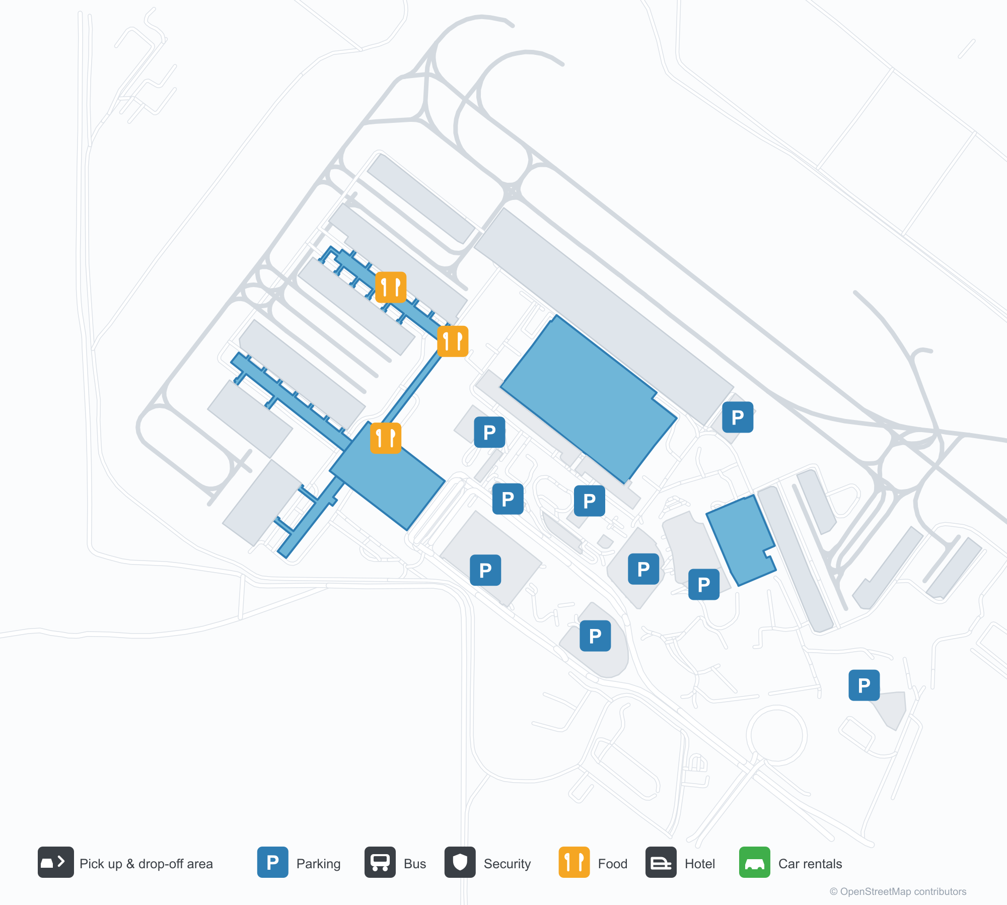
Havalimanı Haritalarını İndirinİndirmeler
Havalimanı fotoğraflarıHavalimanı Fotoğrafları
Bu havalimanının gerçek fotoğrafları; her fotoğrafın altında, fotoğrafın bulunduğu kamuya açık web sayfasına bir atıf yer alır ve telif hakkı özgün fotoğrafçılarda kalır. Yakınlaştırmak için bir fotoğrafa, kaynak sayfasını açmak için bir atıf satırına tıklayın.
Terminalin cam perde duvarına yerleştirilmiş mavi 'Aeroporto Internacional de Viracopos' harfleri.
Bagajla dolu bir araba terminalin beyaz beşik tonozlu çatısının yanında duruyor; iki görevli yanından geçiyor.
Uydu görüntüsünde, Viracopos Uluslararası Havalimanı'nın (VCP) yerleşimi ve çevresi açıkça görülüyor.
Viracopos International Airport rota haritası — doğrudan varış noktalarıRota Haritası
42 doğrudan varış noktası: harita, sefer yapan havayolu şirketleri ve mesafeler.
Viracopos International Airport uçuşları — kalkışlar ve varışlarUçuş Panosu
851 uçuş numarası, 13 havayolu şirketi ve 66 varış noktası, yönlere göre ayrılmıştır. Ortak uçuş numaraları dahildir.
| Uçuş | Havayolu şirketi | Varış noktası | Ülke/bölge |
|---|---|---|---|
| AA7668 | American Airlines | Rio de Janeiro Galeão – Tom Jobim International Airport | Brezilya |
| AC6506 | Air Canada | Rio de Janeiro Galeão – Tom Jobim International Airport | Brezilya |
| AC6512 | Air Canada | Rio de Janeiro Galeão – Tom Jobim International Airport | Brezilya |
| AC6516 | Air Canada | Rio de Janeiro Galeão – Tom Jobim International Airport | Brezilya |
| AD2226 | Azul Brazilian Airlines | São José do Rio Preto (SJP) Prof. Eribelto Manoel Reino State Airport | Brezilya |
| AD2228 | Azul Brazilian Airlines | Uberlândia (UDI) Ten. Cel. Aviador César Bombonato Airport | Brezilya |
| AD2238 | Azul Brazilian Airlines | Goiânia (GYN) Santa Genoveva International Airport | Brezilya |
| AD2254 | Azul Brazilian Airlines | Maceió (MCZ) Zumbi dos Palmares International Airport | Brezilya |
| AD2256 | Azul Brazilian Airlines | Salvador (SSA) Deputado Luiz Eduardo Magalhães International Airport | Brezilya |
| AD2268 | Azul Brazilian Airlines | Fortaleza (FOR) Pinto Martins International Airport | Brezilya |
| AD2400 | Azul Brazilian Airlines | Natal (NAT) Rio Grande do Norte/São Gonçalo do Amarante–Governador Aluízio Alves International Airport | Brezilya |
| AD2402 | Azul Brazilian Airlines | Porto Seguro International Airport | Brezilya |
| AD2406 | Azul Brazilian Airlines | Foz do Iguaçu (IGU) Cataratas International Airport | Brezilya |
| AD2408 | Azul Brazilian Airlines | Porto Seguro International Airport | Brezilya |
| AD2428 | Azul Brazilian Airlines | Porto Alegre (POA) Porto Alegre-Salgado Filho International Airport | Brezilya |
| AD2434 | Azul Brazilian Airlines | Fortaleza (FOR) Pinto Martins International Airport | Brezilya |
| AD2453 | Azul Brazilian Airlines | João Pessoa (JPA) Presidente Castro Pinto International Airport | Brezilya |
| AD2476 | Azul Brazilian Airlines | Porto Seguro International Airport | Brezilya |
| AD2481 | Azul Brazilian Airlines | João Pessoa (JPA) Presidente Castro Pinto International Airport | Brezilya |
| AD2490 | Azul Brazilian Airlines | BYO |
Uçuş numaraları ve rotalar aviability.com uçuş dizininden (anlık görüntü: 26 Ekim 2026); ortak uçuş numaraları dahildir ve kalkış saatleri gösterilmez. Kaynak: aviability.com ↗
Havalimanı bilgileri ve ayrıntılarıHavalimanı Ayrıntıları
Etkileşimli harita — Viracopos International Airport konumuEtkileşimli Harita
Bu havalimanını diğer harita hizmetlerinde görüntüleyin:
Viracopos International Airport GuideHavalimanı Rehberi
Viracopos International Airport (IATA VCP, ICAO SBKP) serves Campinas, Brazil, South America, and is classified as a medium-sized airport. This page gathers what the site's database, maps and route dataset say about it in one place.
Airport photos
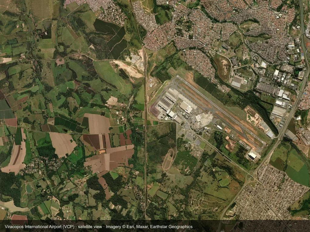
In the satellite image, the layout of Viracopos International Airport (VCP) and its surroundings are clearly visible.
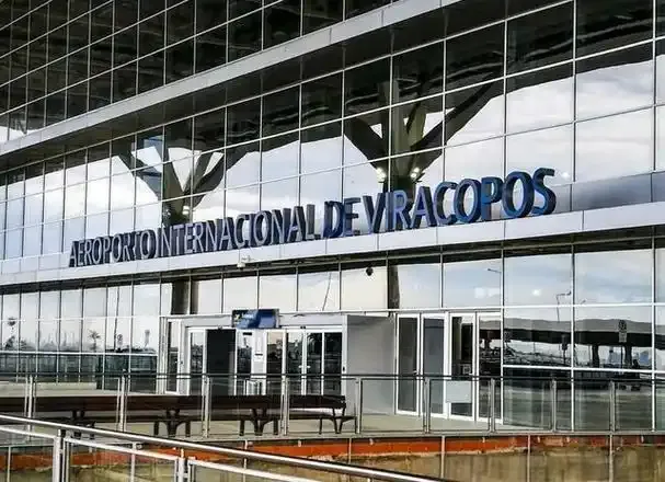
Blue 'Aeroporto Internacional de Viracopos' letters set against the terminal's glass curtain wall.

A cart heaped with luggage stands beside the terminal's white barrel-vaulted roof as two staff walk past.
The photos come from public web sources and remain the copyright of their photographers; full credits and source links sit in the photo gallery on this page.
Facts at a glance
| IATA / ICAO | VCP / SBKP |
| Airport class | medium-sized airport |
| Location | Campinas, Brazil (South America) |
| Coordinates | -23.0074, -47.1345 |
| Direct destinations | 42 (see below) |
Airport map
The map on this page is rendered from OpenStreetMap data: airports with terminal polygons show the terminal buildings, aprons and access roads, while small fields show the airfield outline and runway. Icons for parking, buses, food, hotels and car rentals follow whatever OSM has mapped.
- Full-size view — open the map card on this page to zoom in; the 2000 px original can be downloaded.
- Location map — the interactive map lets you pan and zoom to see the field against the city and road network.
- Schematic — the page also draws a size-based schematic to indicate the airport's scale; it is not the actual layout.
Direct routes
Non-stop destinations, nearest first (OpenFlights route dataset, compiled 2014 — treat as indicative and confirm with the airline):
| Destination | Distance | Main carriers |
|---|---|---|
| Araraquara Airport (AQA) | ~168 km | Azul |
| Leite Lopes Airport (RAO) | ~218 km | Azul |
| Bauru/Arealva–Moussa Nakhal Tobias State Airport (JTC) | ~220 km | Azul |
| Frank Miloye Milenkowichi–Marília State Airport (MII) | ~300 km | Azul |
| Prof. Eribelto Manoel Reino State Airport (SJP) | ~338 km | Azul |
| Curitiba-Afonso Pena International Airport (CWB) | ~348 km | Azul, Sky Express |
| Mário de Almeida Franco Airport (UBA) | ~371 km | Azul |
| Lauro Carneiro de Loyola Airport (JOI) | ~395 km | Azul |
See the Viracopos International Airport route map for the full list of 42 non-stop destinations.
Nearby airports
If nothing fits, these nearby fields are worth comparing:
| Airport | Distance |
|---|---|
| São Paulo/Guarulhos International Airport (GRU) | 82.7 km |
| Congonhas–Deputado Freitas Nobre Airport (CGH) | 84.6 km |
| Araraquara Airport (AQA) | 168 km |
Getting there
The airport: coordinates -23.0074, -47.1345; elevation about 661 m.
Navigate straight to the field:
- Driving / taxi: 高德地图 | 百度地图 | Google Maps
The location map on this page shows the field against the city and road network, and the ground-transport section lists the public transport recorded for it. For driving routes, timetables and parking, rely on the airport's own information.
Size and facilities
Medium-sized airports are regional hubs: one compact terminal, walkable distances and usually faster check-in than a major hub — but with fewer frequencies, so rebooking after a missed flight is harder. Aim for 90–120 minutes before departure.
Terminal plans, check-in locations and ground-transport timetables are published by the airport itself; for detail that must be right on the day, rely on the airport's own information. If something here looks wrong, please tell us via the Contact page and we will check it.
Tips
- If your destination is not in the table above, you will usually connect via Araraquara Airport (AQA) or another larger airport.
- Use the search box at the top of the page to compare alternatives: type a city name or IATA code.
- In peak season parking and rental cars run short at small fields too — book ahead if you are driving.
Okuyucu yorumlarıTartışma
Sorular, seyahat deneyimleri ve düzeltmeler memnuniyetle karşılanır. Yorumlar herkese açıktır.
Yükleniyor…
Yorumlar yükleniyor…