
CN¥990
ชั้นประหยัด · ไป-กลับ
ไม่รวมภาษี
Round-trip fare card per person, taxes excluded; taxes are extra and availability is confirmed at booking. (单人往返不含税机票卡;价格不含税费,实际以出票和税费为准。)
ราคาทางการโพสต์โดย 国泰航空官方ส่งเมื่อ 30 ต.ค. 2569 15:05
ดูดีล Fuzhou (Changle) · จีน· Fuzhou Changle International Airport
Fuzhou Changle International Airport (IATA: FOC, ICAO ZSFZ) เป็นสนามบินขนาดกลางที่ให้บริการFuzhou (Changle), จีน
Fuzhou Changle International Airport (FOC) is a medium airport serving Fuzhou (Changle), China. This page gathers the airport codes, location map and travel information.
ภาพจริงของสนามบินแห่งนี้ พร้อมเครดิตของหน้าเว็บสาธารณะที่พบภาพ; ลิขสิทธิ์ยังเป็นของผู้ถ่ายภาพต้นฉบับ คลิกที่ภาพเพื่อขยาย หรือคลิกบรรทัดเครดิตเพื่อเปิดหน้าแหล่งที่มา
ในภาพถ่ายดาวเทียม มองเห็นผังของสนามบินนานาชาติฝูโจวฉางเล่อ (FOC) และบริเวณโดยรอบได้อย่างชัดเจน
47 จุดหมายบินตรง: แผนที่ สายการบินที่ให้บริการ และระยะทาง
1,108 หมายเลขเที่ยวบิน ครอบคลุม 49 สายการบิน และ 85 จุดหมายปลายทาง แยกตามทิศทาง หมายเลขเที่ยวบินร่วม (codeshare) รวมอยู่ด้วย
| เที่ยวบิน | สายการบิน | จุดหมายปลายทาง | ประเทศ/ภูมิภาค |
|---|---|---|---|
| 3U1892 | Sichuan Airlines | Zhengzhou Xinzheng International Airport | จีน |
| 3U2215 | Sichuan Airlines | Jinan Yaoqiang International Airport | จีน |
| 3U2241 | Sichuan Airlines | Changzhou (CZX) Changzhou Benniu International Airport | จีน |
| 3U2245 | Sichuan Airlines | Nanjing Lukou International Airport | จีน |
| 3U2249 | Sichuan Airlines | Jinan Yaoqiang International Airport | จีน |
| 3U2251 | Sichuan Airlines | Nanjing Lukou International Airport | จีน |
| 3U2271 | Sichuan Airlines | Beijing Daxing International Airport | จีน |
| 3U2273 | Sichuan Airlines | Beijing Daxing International Airport | จีน |
| 3U2277 | Sichuan Airlines | Beijing Daxing International Airport | จีน |
| 3U2281 | Sichuan Airlines | Beijing Daxing International Airport | จีน |
| 3U2297 | Sichuan Airlines | Tianjin Binhai International Airport | จีน |
| 3U2301 | Sichuan Airlines | Tianjin Binhai International Airport | จีน |
| 3U2317 | Sichuan Airlines | Zhengzhou Xinzheng International Airport | จีน |
| 3U2323 | Sichuan Airlines | Beijing Daxing International Airport | จีน |
| 3U2329 | Sichuan Airlines | Beijing Daxing International Airport | จีน |
| 3U2333 | Sichuan Airlines | Taiyuan Wusu International Airport | จีน |
| 3U2341 | Sichuan Airlines | Nanjing Lukou International Airport | จีน |
| 3U2343 | Sichuan Airlines | Tianjin Binhai International Airport | จีน |
| 3U2393 | Sichuan Airlines | Wuhan Tianhe International Airport | จีน |
| 3U2395 | Sichuan Airlines | Xi'an Xianyang International Airport | จีน |
หมายเลขเที่ยวบินและเส้นทางจากดัชนีเที่ยวบิน aviability.com (ข้อมูล ณ วันที่ 26 ตุลาคม 2569); รวมหมายเลขเที่ยวบินร่วมและไม่แสดงเวลาเดินทาง ที่มา: aviability.com ↗
ลิงก์จองบางรายการเป็นลิงก์พันธมิตรของผู้ส่ง และผู้ส่งอาจได้รับค่าคอมมิชชัน ราคาเป็นข้อมูลที่ผู้ใช้ส่งเข้ามาและยังไม่ได้ตรวจสอบ โปรดยืนยันกับสายการบินหรือหน้าจองเสมอ
Round-trip fare card per person, taxes excluded; taxes are extra and availability is confirmed at booking. (单人往返不含税机票卡;价格不含税费,实际以出票和税费为准。)
Round-trip fare card per person, taxes excluded; taxes are extra and availability is confirmed at booking. (单人往返不含税机票卡;价格不含税费,实际以出票和税费为准。)
Round-trip fare card per person, taxes excluded; taxes are extra and availability is confirmed at booking. (单人往返不含税机票卡;价格不含税费,实际以出票和税费为准。)
ดูสนามบินนี้บนบริการแผนที่อื่น:
Fuzhou Changle International Airport (IATA FOC, ICAO ZSFZ) serves Fuzhou (Changle), China, East Asia, and is classified as a medium-sized airport. This page gathers what the site's database, maps and route dataset say about it in one place.
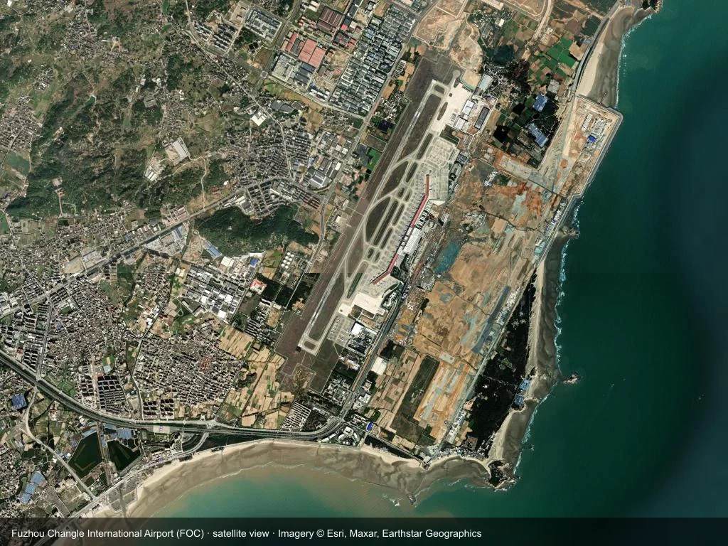
In the satellite image, the layout of Fuzhou Changle International Airport (FOC) and its surroundings are clearly visible.
The photos come from public web sources and remain the copyright of their photographers; full credits and source links sit in the photo gallery on this page.
| IATA / ICAO | FOC / ZSFZ |
| Airport class | medium-sized airport |
| Location | Fuzhou (Changle), China (East Asia) |
| Coordinates | 25.9293, 119.6725 |
| Direct destinations | 47 (see below) |
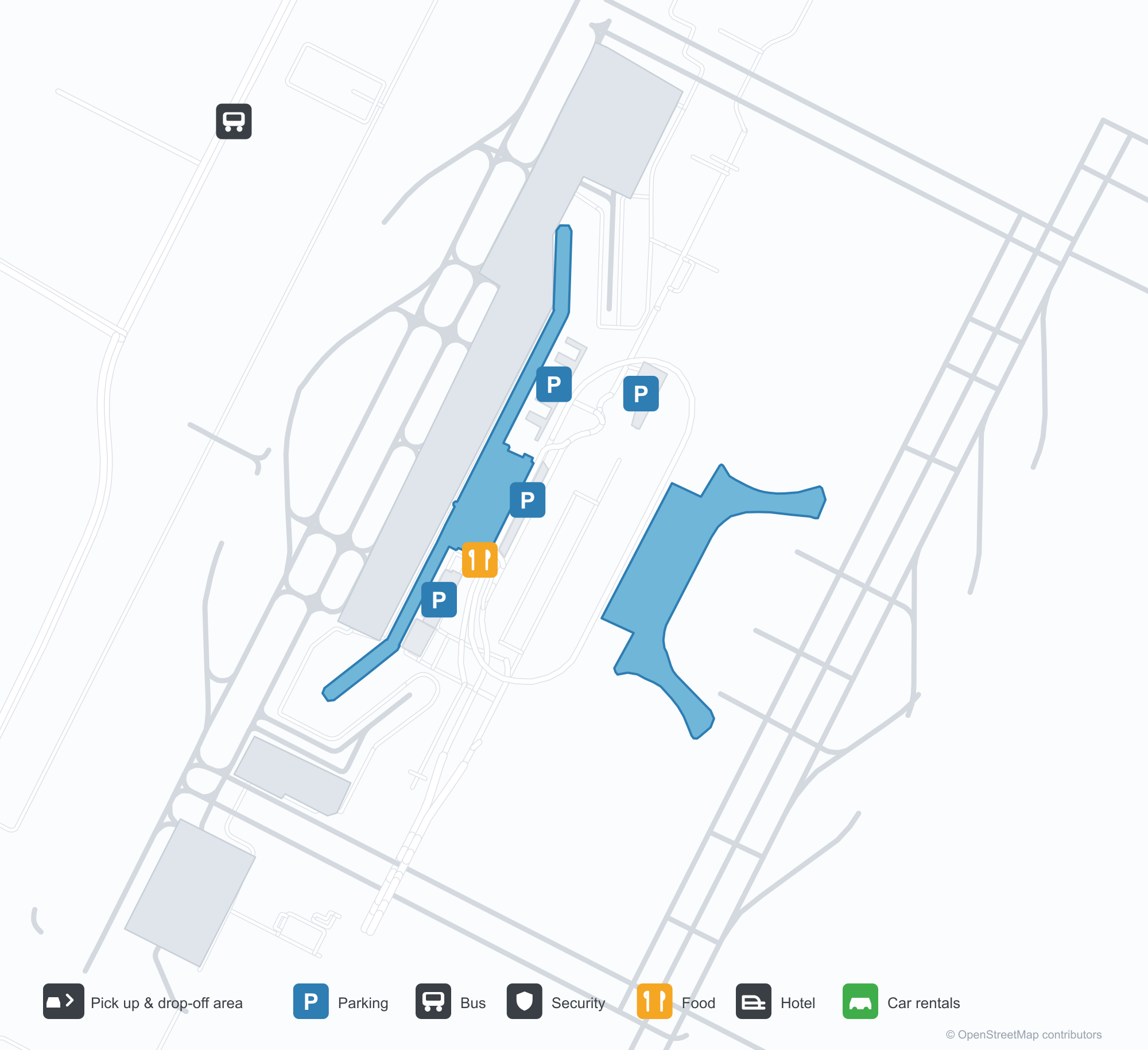
The map on this page is rendered from OpenStreetMap data: airports with terminal polygons show the terminal buildings, aprons and access roads, while small fields show the airfield outline and runway. Icons for parking, buses, food, hotels and car rentals follow whatever OSM has mapped.
Non-stop destinations, nearest first (OpenFlights route dataset, compiled 2014 — treat as indicative and confirm with the airline):
| Destination | Distance | Main carriers |
|---|---|---|
| Taiwan Taoyuan International Airport (TPE) | ~183 km | Uni Air, Xiamen Airlines |
| Taichung International Airport (RMQ) | ~208 km | TransAsia Airways |
| Taipei Songshan Airport (TSA) | ~212 km | Mandarin Airlines, TransAsia Airways |
| Kaohsiung International Airport (KHH) | ~379 km | Uni Air, TransAsia Airways |
| Jingdezhen Luojia Airport (JDZ) | ~452 km | Air China, Shenzhen Airlines |
| Hangzhou Xiaoshan International Airport (HGH) | ~485 km | China Southern Airlines, Xiamen Airlines |
| Shanghai Hongqiao International Airport (SHA) | ~608 km | China Southern Airlines, Shanghai Airlines |
| Shanghai Pudong International Airport (PVG) | ~616 km | Juneyao Airlines, China Eastern Airlines |
See the Fuzhou Changle International Airport route map for the full list of 47 non-stop destinations.
If nothing fits, these nearby fields are worth comparing:
| Airport | Distance |
|---|---|
| Matsu Nangan Airport (LZN) | 38.4 km |
| Matsu Beigan Airport (MFK) | 46.5 km |
| Taiwan Taoyuan International Airport (TPE) | 183 km |
The airport: coordinates 25.9293, 119.6725; elevation about 14 m.
Navigate straight to the field:
The location map on this page shows the field against the city and road network, and the ground-transport section lists the public transport recorded for it. For driving routes, timetables and parking, rely on the airport's own information.
Medium-sized airports are regional hubs: one compact terminal, walkable distances and usually faster check-in than a major hub — but with fewer frequencies, so rebooking after a missed flight is harder. Aim for 90–120 minutes before departure.
Terminal plans, check-in locations and ground-transport timetables are published by the airport itself; for detail that must be right on the day, rely on the airport's own information. If something here looks wrong, please tell us via the Contact page and we will check it.
ความคิดเห็นจากผู้อ่านการสนทนา
ยินดีรับคำถาม รายงานการเดินทาง และการแก้ไข ความคิดเห็นเป็นสาธารณะ
กำลังโหลด…
กำลังโหลดความคิดเห็น…