
Arutua Airport
 Arutua · Polinésia Francesa· Arutua Airport
O Arutua Airport (IATA: AXR, ICAO NTGU) é um aeroporto de porte médio que atende Arutua, Polinésia Francesa.
Arutua Airport is a medium-sized airport, at an elevation of about 9 ft, with scheduled passenger service. This page gathers its location map, airport codes and travel information.

Baixar mapas do aeroportoDownloads
Fotos do aeroportoFotos do aeroporto
Fotos reais deste aeroporto, cada uma creditada à página pública da web onde foi encontrada; os direitos autorais continuam com os fotógrafos originais. Clique em uma foto para ampliar ou em uma linha de crédito para abrir a página de origem.
Vista de satélite: a pista de Arutua fica em uma ilhota de atol nas Tuamotus, com o terminal e o pátio ao lado e lagoa ao redor.
Arutua Airport: mapa de rotas — destinos diretosMapa de rotas
1 destinos diretos: mapa, companhias aéreas em operação e distâncias.
Arutua Airport: voos — partidas e chegadasPainel de voos
9 números de voo de 1 companhia aérea para 3 destinos, separados por direção. Números de codeshare estão incluídos.
| Voo | Companhia aérea | Destino | País/região |
|---|---|---|---|
| VT585 | Air Tahiti | Papeete (PPT) Fa'a'ā International Airport | Polinésia Francesa |
| VT586 | Air Tahiti | Ahe Airport | Polinésia Francesa |
| VT589 | Air Tahiti | Ahe Airport | Polinésia Francesa |
| VT598 | Air Tahiti | Ahe Airport | Polinésia Francesa |
| VT598 | Air Tahiti | Papeete (PPT) Fa'a'ā International Airport | Polinésia Francesa |
Números de voo e rotas do índice de voos da aviability.com (instantâneo de 26 de outubro de 2026); números de codeshare estão incluídos e nenhum horário de partida é exibido. Fonte: aviability.com ↗
Informações e detalhes do aeroportoDetalhes do aeroporto
Mapa interativo — localização do Arutua AirportMapa interativo
Veja este aeroporto em outros serviços de mapas:
Arutua Airport (AXR): One Route in the Tuamotu AtollsGuia do aeroporto
From above, Arutua's runway lies on an atoll islet in the Tuamotus, with the terminal and apron alongside it and lagoon around. The airport serves Arutua in French Polynesia at an elevation of about 3 m, with a 1,301 m runway; the 2014 snapshot records one domestic destination, Kaukura at 54 km.
Satellite view
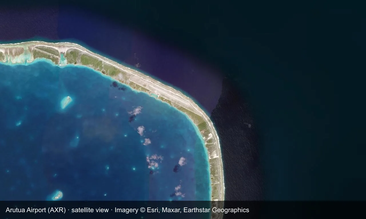
Satellite view: Arutua's runway lies on an atoll islet in the Tuamotus, with the terminal and apron alongside it and lagoon around.
The satellite image comes from Esri World Imagery (© Esri, Maxar, Earthstar Geographics); the field and attribution are labelled in the image. This is a satellite view, not a ground-level photograph.
Airport at a glance
| Item | Detail |
|---|---|
| IATA / ICAO | AXR / NTGU |
| Role | Medium-sized airport |
| Elevation | about 3 m |
| Coordinates | -15.2483, -146.6170 |
| Runways | 1, 1,301 m |
| Non-stop destinations | 1 (Kaukura; 2014 snapshot) |
Runways
| Runway | Length | Width | Surface |
|---|---|---|---|
| 10/28 | 1,301 m | 30 m | asphalt |
1 runway, the longest 1,301 m.
Non-stop routes
1 non-stop destinations, nearest first (OpenFlights route snapshot compiled in 2014 — confirm with the airline or airport):
| Destination | Distance | Carriers |
|---|---|---|
| Kaukura Airport (KKR) | ~54 km | Air Tahiti |
The carrier column comes from the same snapshot and includes codeshare and interline services; treat it as an indication of how busy the route is and check the airline for who actually flies it.
Nearby airports to compare
If the fares are close, these are the nearest airports of the same class (medium-sized airport) — straight-line distance, with their own non-stop counts from the same dataset:
| Airport | Distance | Non-stop destinations |
|---|---|---|
| Ahe Airport (AHE) | ~99 km | 2 |
| Anaa Airport (AAA) | ~262 km | — |
Before you fly
- Atoll flights use small turboprops with strict baggage and payload limits.
- The lagoon and reef are fragile, and island activities follow local rules.
About the data
Runways, elevation and coordinates come from OurAirports open data. Routes and carriers come from the June 2014 OpenFlights snapshot and include codeshares and interline services; they indicate network shape and scale, not current schedules.
Comentários dos leitoresDiscussão
Perguntas, relatos de viagem e correções são bem-vindos. Os comentários são públicos.
Carregando…
Carregando comentários…