
Baltimore/Washington International Thurgood Marshall Airport
 Baltimore · アメリカ合衆国· Baltimore/Washington International Thurgood Marshall Airport
Baltimore/Washington International Thurgood Marshall Airport(IATA: BWI、ICAO: KBWI)はBaltimore、アメリカ合衆国にある大型空港です。
Baltimore/Washington International Thurgood Marshall Airport (BWI) is a large international airport serving Baltimore, United States. This page gathers the airport codes, location map and travel information.
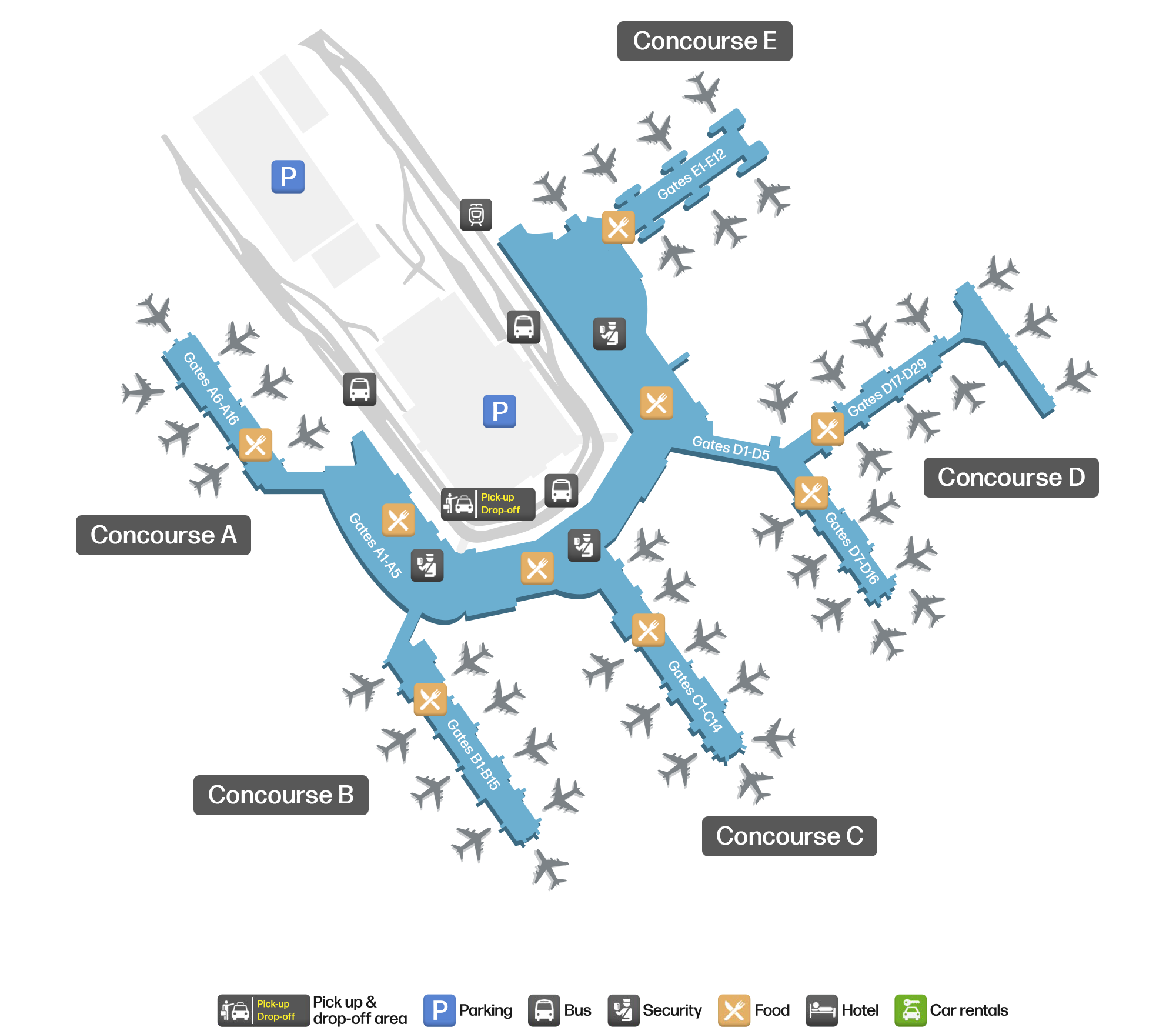
空港マップをダウンロードダウンロード
空港写真空港写真
この空港の実際の写真です。いずれも公開ウェブページを出典として明記しており、著作権は撮影者に帰属します。写真をクリックすると拡大表示され、クレジットをクリックすると元のページが開きます。
客室窓から眺めると、サウスウエストの機体がゲートに並び、日差しを受けたエプロンに地上車両や手荷物カートが散らばっている。
衛星画像では、ボルチモア・ワシントン国際サーグッド・マーシャル空港(BWI)の配置と周辺の様子がはっきりと確認できる。
Baltimore/Washington International Thurgood Marshall Airportの路線マップ — 直行便の目的地路線マップ
直行目的地71か所。地図、就航航空会社、距離を掲載しています。
Baltimore/Washington International Thurgood Marshall Airport発着便 — 出発と到着フライトボード
便名5,577件、45社の航空会社、88か所の目的地を出発・到着別に掲載しています。コードシェア便も含みます。
| 便 | 航空会社 | 目的地 | 国・地域 |
|---|---|---|---|
| 2T151 | Bermudair | The Valley (AXA) Clayton J. Lloyd International Airport | アンギラ |
| 2T183 | Bermudair | Providenciales (PLS) Providenciales International Airport | タークス・カイコス諸島 |
| 2T552 | Bermudair | Hamilton (BDA) L.F. Wade International Airport | バミューダ |
| 2T554 | Bermudair | Hamilton (BDA) L.F. Wade International Airport | バミューダ |
| AA470 | American Airlines | Charlotte Douglas International Airport | アメリカ合衆国 |
| AA479 | American Airlines | Charlotte Douglas International Airport | アメリカ合衆国 |
| AA513 | American Airlines | Dallas Fort Worth International Airport | アメリカ合衆国 |
| AA514 | American Airlines | Charlotte Douglas International Airport | アメリカ合衆国 |
| AA521 | American Airlines | Dallas Fort Worth International Airport | アメリカ合衆国 |
| AA550 | American Airlines | Charlotte Douglas International Airport | アメリカ合衆国 |
| AA642 | American Airlines | Dallas Fort Worth International Airport | アメリカ合衆国 |
| AA644 | American Airlines | マイアミ国際空港 | アメリカ合衆国 |
| AA652 | American Airlines | マイアミ国際空港 | アメリカ合衆国 |
| AA689 | American Airlines | Charlotte Douglas International Airport | アメリカ合衆国 |
| AA716 | American Airlines | マイアミ国際空港 | アメリカ合衆国 |
| AA744 | American Airlines | Charlotte Douglas International Airport | アメリカ合衆国 |
| AA986 | American Airlines | オヘア国際空港 | アメリカ合衆国 |
| AA1183 | American Airlines | マイアミ国際空港 | アメリカ合衆国 |
| AA1213 | American Airlines | Dallas Fort Worth International Airport | アメリカ合衆国 |
| AA1216 | American Airlines | Charlotte Douglas International Airport | アメリカ合衆国 |
便名と路線はaviability.comのフライトインデックス(スナップショット:2026年10月26日)に基づきます。コードシェア便を含み、出発時刻は掲載していません。出典:aviability.com ↗
空港情報と詳細空港の詳細
インタラクティブマップ — Baltimore/Washington International Thurgood Marshall Airportの位置インタラクティブマップ
他の地図サービスでこの空港を見る:
Baltimore/Washington International Thurgood Marshall Airport Guide空港ガイド
Baltimore/Washington International Thurgood Marshall Airport (IATA BWI, ICAO KBWI) serves Baltimore, United States, North America, and is classified as a large airport. This page gathers what the site's database, maps and route dataset say about it in one place.
Facts at a glance
| IATA / ICAO | BWI / KBWI |
| Airport class | large airport |
| Location | Baltimore, United States (North America) |
| Coordinates | 39.1754, -76.6683 |
| Direct destinations | 71 (see below) |
Airport map
The map on this page is rendered from OpenStreetMap data: airports with terminal polygons show the terminal buildings, aprons and access roads, while small fields show the airfield outline and runway. Icons for parking, buses, food, hotels and car rentals follow whatever OSM has mapped.
- Full-size view — open the map card on this page to zoom in; the 2000 px original can be downloaded.
- Location map — the interactive map lets you pan and zoom to see the field against the city and road network.
- Schematic — the page also draws a size-based schematic to indicate the airport's scale; it is not the actual layout.
Direct routes
Non-stop destinations, nearest first (OpenFlights route dataset, compiled 2014 — treat as indicative and confirm with the airline):
| Destination | Distance | Main carriers |
|---|---|---|
| Philadelphia International Airport (PHL) | ~145 km | American Airlines, US Airways |
| Norfolk International Airport (ORF) | ~257 km | AirTran Airways, Southwest Airlines |
| Newark Liberty International Airport (EWR) | ~271 km | United Airlines |
| John F. Kennedy International Airport (JFK) | ~295 km | American Airlines, Delta Air Lines |
| Pittsburgh International Airport (PIT) | ~338 km | AirTran Airways, Southwest Airlines |
| Long Island MacArthur Airport (ISP) | ~353 km | AirTran Airways, Southwest Airlines |
| Raleigh-Durham International Airport (RDU) | ~411 km | Delta Air Lines, AirTran Airways |
| Frederick Douglass Greater Rochester International Airport (ROC) | ~446 km | AirTran Airways, Southwest Airlines |
See the Baltimore/Washington International Thurgood Marshall Airport route map for the full list of 71 non-stop destinations.
Nearby airports
If nothing fits, these nearby fields are worth comparing:
| Airport | Distance |
|---|---|
| Joint Base Andrews (ADW) | 44 km |
| Ronald Reagan Washington National Airport (DCA) | 48.1 km |
| Washington Dulles International Airport (IAD) | 72.7 km |
Getting there
The airport: coordinates 39.1754, -76.6683; elevation about 45 m.
Navigate straight to the field:
- Driving / taxi: 高德地图 | 百度地图 | Google Maps
The location map on this page shows the field against the city and road network, and the ground-transport section lists the public transport recorded for it. For driving routes, timetables and parking, rely on the airport's own information.
Size and facilities
Large airports run multiple runways and terminals and handle millions of passengers a year. Queue times at check-in and security vary strongly by time of day; for international flights plan to arrive 2–3 hours before departure.
Terminal plans, check-in locations and ground-transport timetables are published by the airport itself; for detail that must be right on the day, rely on the airport's own information. If something here looks wrong, please tell us via the Contact page and we will check it.
Tips
- If your destination is not in the table above, you will usually connect via Philadelphia International Airport (PHL) or another larger airport.
- Use the search box at the top of the page to compare alternatives: type a city name or IATA code.
- In peak season parking and rental cars run short at small fields too — book ahead if you are driving.
読者コメントディスカッション
質問、旅行記、訂正など、お気軽にお寄せください。コメントは公開されます。
読み込み中…
コメントを読み込み中…