
St. Louis Lambert International Airport
 St Louis · Amerika Serikat· St. Louis Lambert International Airport
St. Louis Lambert International Airport (IATA: STL, ICAO KSTL) adalah bandara sedang yang melayani St Louis, Amerika Serikat.
St. Louis Lambert International Airport (STL) is a medium airport serving St Louis, United States. This page gathers the airport codes, location map and travel information.
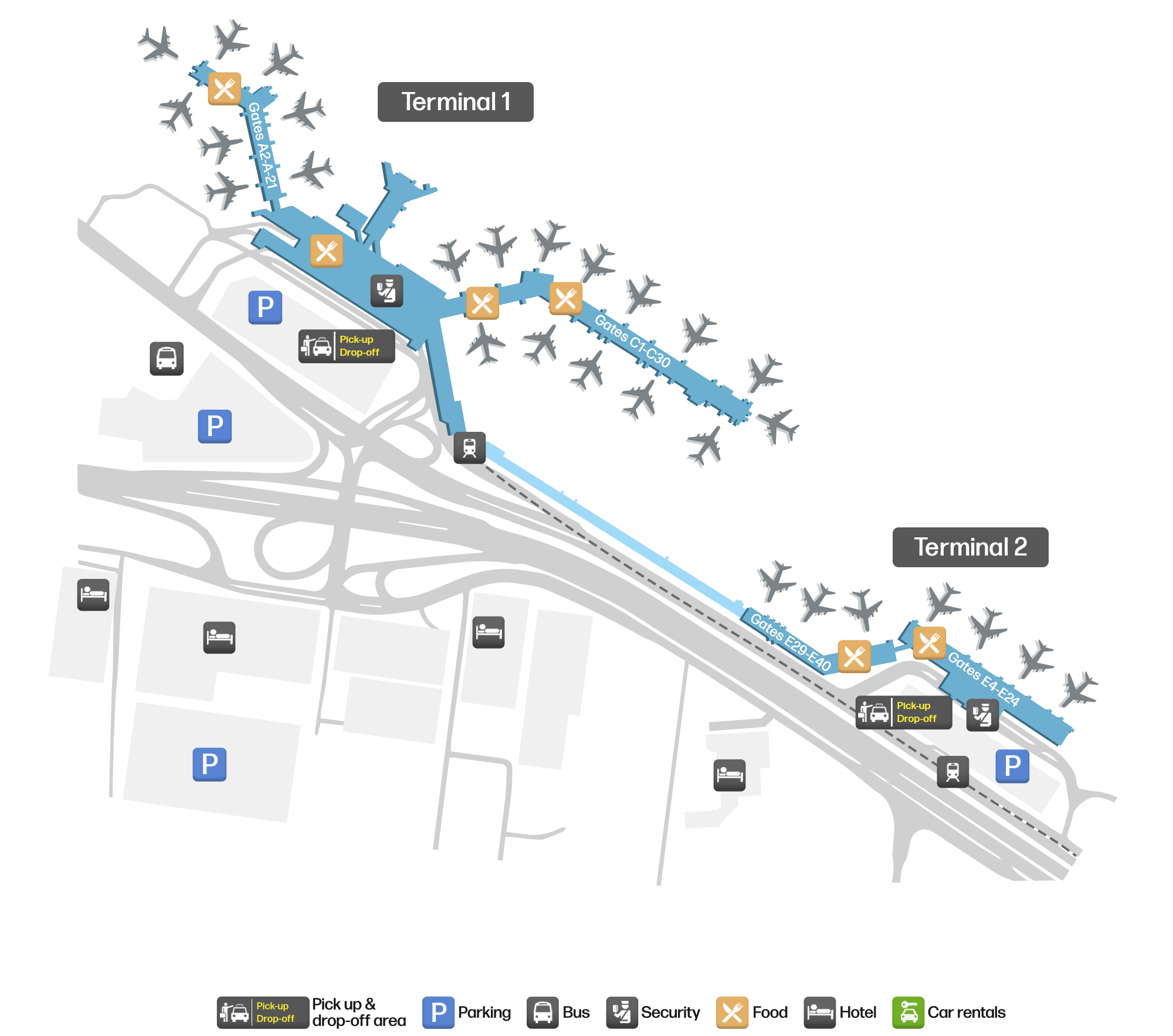
Unduh Peta BandaraUnduhan
Foto bandaraFoto Bandara
Foto asli bandara ini, masing-masing dikreditkan ke halaman web publik tempat foto ditemukan; hak cipta tetap milik fotografer aslinya. Klik foto untuk memperbesar, atau baris kredit untuk membuka halaman sumbernya.
Menara kontrol St. Louis Lambert menjulang di belakang terminal beratap kaca melengkung dalam kabut.
Pada citra satelit, tata letak Bandara Internasional St. Louis Lambert (STL) dan sekitarnya terlihat dengan jelas.
Peta rute St. Louis Lambert International Airport — tujuan langsungPeta Rute
60 tujuan langsung: peta, maskapai yang beroperasi, dan jarak.
Penerbangan St. Louis Lambert International Airport — keberangkatan & kedatanganPapan Penerbangan
4.012 nomor penerbangan dari 45 maskapai dan 61 tujuan, dipisahkan menurut arah. Nomor codeshare disertakan.
| Penerbangan | Maskapai | Tujuan | Negara/wilayah |
|---|---|---|---|
| 9X457 | Southern Airways Express | Jonesboro (JBR) Jonesboro Municipal Airport | Amerika Serikat |
| AA321 | American Airlines | Phoenix Sky Harbor International Airport | Amerika Serikat |
| AA363 | American Airlines | Bandara Internasional O'Hare | Amerika Serikat |
| AA453 | American Airlines | Dallas Fort Worth International Airport | Amerika Serikat |
| AA477 | American Airlines | Bandara Internasional Miami | Amerika Serikat |
| AA537 | American Airlines | Dallas Fort Worth International Airport | Amerika Serikat |
| AA567 | American Airlines | Bandara Internasional Miami | Amerika Serikat |
| AA590 | American Airlines | Phoenix Sky Harbor International Airport | Amerika Serikat |
| AA712 | American Airlines | Charlotte Douglas International Airport | Amerika Serikat |
| AA725 | American Airlines | Bandara Internasional Miami | Amerika Serikat |
| AA769 | American Airlines | Dallas Fort Worth International Airport | Amerika Serikat |
| AA1167 | American Airlines | Charlotte Douglas International Airport | Amerika Serikat |
| AA1250 | American Airlines | Charlotte Douglas International Airport | Amerika Serikat |
| AA1329 | American Airlines | Dallas Fort Worth International Airport | Amerika Serikat |
| AA1363 | American Airlines | Dallas Fort Worth International Airport | Amerika Serikat |
| AA1410 | American Airlines | Dallas Fort Worth International Airport | Amerika Serikat |
| AA1462 | American Airlines | Charlotte Douglas International Airport | Amerika Serikat |
| AA1466 | American Airlines | Phoenix Sky Harbor International Airport | Amerika Serikat |
| AA1515 | American Airlines | Charlotte Douglas International Airport | Amerika Serikat |
| AA1713 | American Airlines | Bandara Internasional O'Hare | Amerika Serikat |
Nomor penerbangan dan rute dari indeks penerbangan aviability.com (cuplikan 26 Oktober 2026); nomor codeshare disertakan dan waktu keberangkatan tidak ditampilkan. Sumber: aviability.com ↗
Informasi & detail bandaraDetail Bandara
Peta interaktif — lokasi St. Louis Lambert International AirportPeta Interaktif
Lihat bandara ini di layanan peta lain:
St. Louis Lambert International Airport GuidePanduan Bandara
St. Louis Lambert International Airport (IATA STL, ICAO KSTL) serves St Louis, United States, North America, and is classified as a medium-sized airport. This page gathers what the site's database, maps and route dataset say about it in one place.
Facts at a glance
| IATA / ICAO | STL / KSTL |
| Airport class | medium-sized airport |
| Location | St Louis, United States (North America) |
| Coordinates | 38.7487, -90.3700 |
| Direct destinations | 60 (see below) |
Airport map
The map on this page is rendered from OpenStreetMap data: airports with terminal polygons show the terminal buildings, aprons and access roads, while small fields show the airfield outline and runway. Icons for parking, buses, food, hotels and car rentals follow whatever OSM has mapped.
- Full-size view — open the map card on this page to zoom in; the 2000 px original can be downloaded.
- Location map — the interactive map lets you pan and zoom to see the field against the city and road network.
- Schematic — the page also draws a size-based schematic to indicate the airport's scale; it is not the actual layout.
Direct routes
Non-stop destinations, nearest first (OpenFlights route dataset, compiled 2014 — treat as indicative and confirm with the airline):
| Destination | Distance | Main carriers |
|---|---|---|
| Quincy Regional Airport Baldwin Field (UIN) | ~151 km | Cape Air |
| Veterans Airport of Southern Illinois (MWA) | ~162 km | Cape Air |
| Decatur Airport (DEC) | ~177 km | Air Choice One |
| Cape Girardeau Regional Airport (CGI) | ~183 km | Cape Air |
| Waynesville-St. Robert Regional Airport-Forney Field (TBN) | ~191 km | Cape Air |
| Southeast Iowa Regional Airport (BRL) | ~235 km | Air Choice One |
| Kirksville Regional Airport (IRK) | ~239 km | Cape Air |
| Owensboro Daviess County Airport (OWB) | ~301 km | Cape Air |
See the St. Louis Lambert International Airport route map for the full list of 60 non-stop destinations.
Nearby airports
If nothing fits, these nearby fields are worth comparing:
| Airport | Distance |
|---|---|
| Abraham Lincoln Capital Airport (SPI) | 136 km |
| Arkansas International Airport (BYH) | 312 km |
| Indianapolis International Airport (IND) | 367 km |
Getting there
The airport: coordinates 38.7487, -90.3700; elevation about 188 m.
Navigate straight to the field:
- Driving / taxi: 高德地图 | 百度地图 | Google Maps
The location map on this page shows the field against the city and road network, and the ground-transport section lists the public transport recorded for it. For driving routes, timetables and parking, rely on the airport's own information.
Size and facilities
Medium-sized airports are regional hubs: one compact terminal, walkable distances and usually faster check-in than a major hub — but with fewer frequencies, so rebooking after a missed flight is harder. Aim for 90–120 minutes before departure.
Terminal plans, check-in locations and ground-transport timetables are published by the airport itself; for detail that must be right on the day, rely on the airport's own information. If something here looks wrong, please tell us via the Contact page and we will check it.
Tips
- If your destination is not in the table above, you will usually connect via Quincy Regional Airport Baldwin Field (UIN) or another larger airport.
- Use the search box at the top of the page to compare alternatives: type a city name or IATA code.
- In peak season parking and rental cars run short at small fields too — book ahead if you are driving.
Komentar pembacaDiskusi
Pertanyaan, laporan perjalanan, dan koreksi sangat kami harapkan. Komentar bersifat publik.
Memuat…
Memuat komentar…