
El Dorado International Airport
 Bogotá · Kolombia· El Dorado International Airport
El Dorado International Airport (IATA: BOG, ICAO SKBO) adalah bandara besar yang melayani Bogotá, Kolombia.
El Dorado International Airport (BOG) is a large international airport serving Bogota, Colombia. This page gathers the airport codes, location map and travel information.
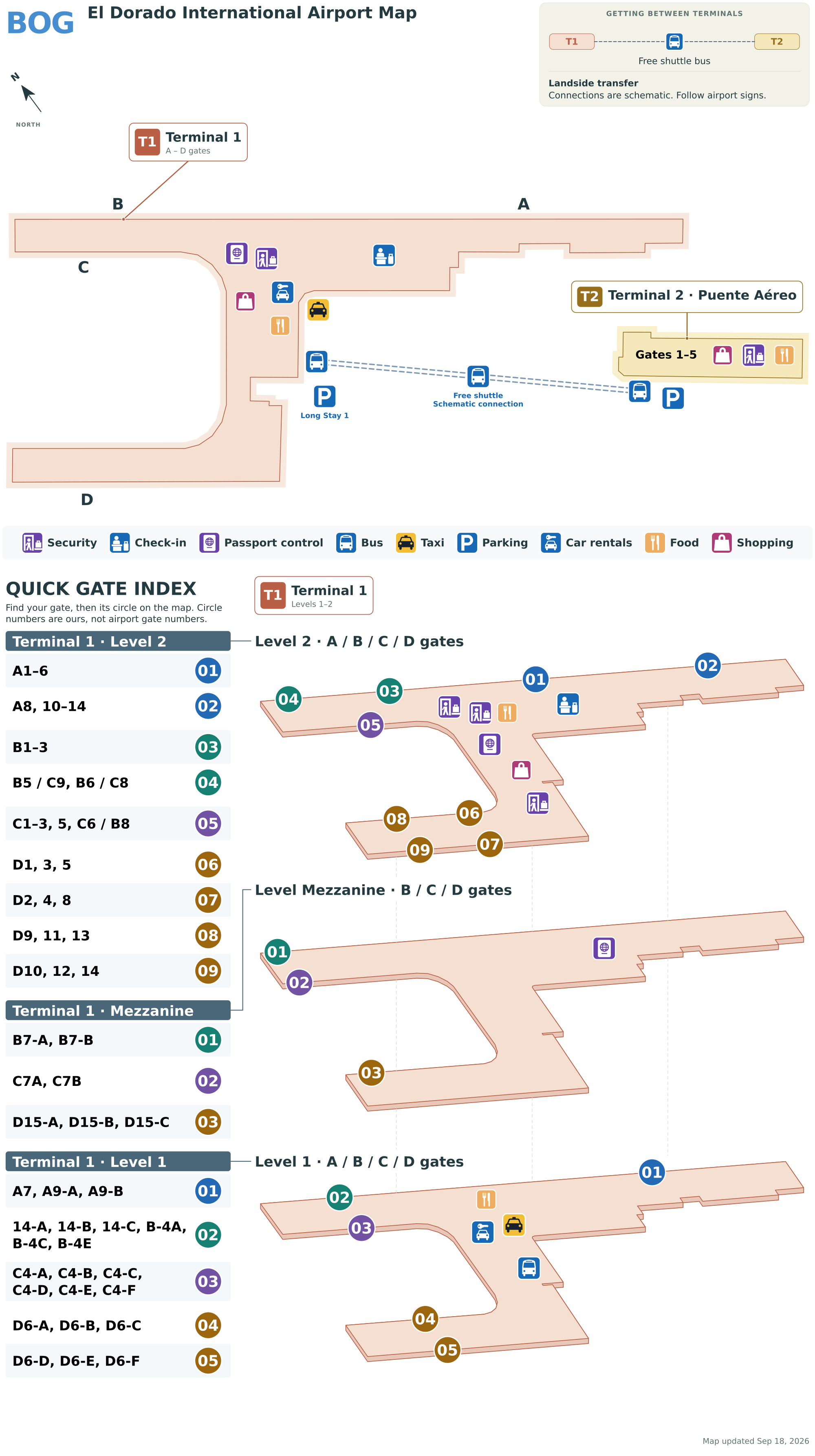
Unduh Peta BandaraUnduhan
Foto bandaraFoto Bandara
Foto asli bandara ini, masing-masing dikreditkan ke halaman web publik tempat foto ditemukan; hak cipta tetap milik fotografer aslinya. Klik foto untuk memperbesar, atau baris kredit untuk membuka halaman sumbernya.
Di apron Bandara El Dorado Bogotá — pesawat LATAM dan Avianca di gerbang terminal, dengan menara-menara apartemen kota di belakang.
Pada citra satelit, tata letak Bandara Internasional El Dorado (BOG) dan sekitarnya terlihat dengan jelas.
Peta rute El Dorado International Airport — tujuan langsungPeta Rute
72 tujuan langsung: peta, maskapai yang beroperasi, dan jarak.
Penerbangan El Dorado International Airport — keberangkatan & kedatanganPapan Penerbangan
4.403 nomor penerbangan dari 53 maskapai dan 108 tujuan, dipisahkan menurut arah. Nomor codeshare disertakan.
| Penerbangan | Maskapai | Tujuan | Negara/wilayah |
|---|---|---|---|
| 9R7704 | Satena | Puerto Asís (PUU) Tres De Mayo Airport | Kolombia |
| 9R8602 | Satena | Medellín (EOH) Enrique Olaya Herrera Airport | Kolombia |
| 9R8604 | Satena | Medellín (EOH) Enrique Olaya Herrera Airport | Kolombia |
| 9R8606 | Satena | Medellín (EOH) Enrique Olaya Herrera Airport | Kolombia |
| 9R8616 | Satena | Medellín (EOH) Enrique Olaya Herrera Airport | Kolombia |
| 9R8632 | Satena | San Vicente Del Caguán (SVI) Eduardo Falla Solano Airport | Kolombia |
| 9R8645 | Satena | Florencia (FLA) Gustavo Artunduaga Paredes Airport | Kolombia |
| 9R8658 | Satena | Puerto Asís (PUU) Tres De Mayo Airport | Kolombia |
| 9R8686 | Satena | Tumaco (TCO) La Florida Airport | Kolombia |
| 9R8690 | Satena | Corozal (CZU) Las Brujas Airport | Kolombia |
| 9R8700 | Satena | Corozal (CZU) Las Brujas Airport | Kolombia |
| 9R8702 | Satena | Puerto Carreño (PCR) German Olano Airport | Kolombia |
| 9R8704 | Satena | Puerto Inírida (PDA) Obando Cesar Gaviria Trujillo Airport | Kolombia |
| 9R8710 | Satena | Arauca (AUC) Santiago Perez Airport | Kolombia |
| 9R8712 | Satena | Arauca (AUC) Santiago Perez Airport | Kolombia |
| 9R8714 | Satena | Arauca (AUC) Santiago Perez Airport | Kolombia |
| 9R8718 | Satena | Tame (TME) Gustavo Vargas Airport | Kolombia |
| 9R8720 | Satena | Tumaco (TCO) La Florida Airport | Kolombia |
| 9R8722 | Satena | Corozal (CZU) Las Brujas Airport | Kolombia |
| 9R8724 | Satena | Quibdó (UIB) El Caraño Airport | Kolombia |
Nomor penerbangan dan rute dari indeks penerbangan aviability.com (cuplikan 26 Oktober 2026); nomor codeshare disertakan dan waktu keberangkatan tidak ditampilkan. Sumber: aviability.com ↗
Informasi & detail bandaraDetail Bandara
Peta interaktif — lokasi El Dorado International AirportPeta Interaktif
Lihat bandara ini di layanan peta lain:
El Dorado International Airport GuidePanduan Bandara
El Dorado International Airport (IATA BOG, ICAO SKBO) serves Bogota, Colombia, South America, and is classified as a large airport. This page gathers what the site's database, maps and route dataset say about it in one place.
Facts at a glance
| IATA / ICAO | BOG / SKBO |
| Airport class | large airport |
| Location | Bogota, Colombia (South America) |
| Coordinates | 4.7016, -74.1469 |
| Direct destinations | 72 (see below) |
Airport map
The map on this page is rendered from OpenStreetMap data: airports with terminal polygons show the terminal buildings, aprons and access roads, while small fields show the airfield outline and runway. Icons for parking, buses, food, hotels and car rentals follow whatever OSM has mapped.
- Full-size view — open the map card on this page to zoom in; the 2000 px original can be downloaded.
- Location map — the interactive map lets you pan and zoom to see the field against the city and road network.
- Schematic — the page also draws a size-based schematic to indicate the airport's scale; it is not the actual layout.
Direct routes
Non-stop destinations, nearest first (OpenFlights route dataset, compiled 2014 — treat as indicative and confirm with the airline):
| Destination | Distance | Main carriers |
|---|---|---|
| Vanguardia Airport (VVC) | ~84 km | SATENA, Avianca - Aerovias Nacionales de Colombia |
| Perales Airport (IBE) | ~114 km | Avianca - Aerovias Nacionales de Colombia, LAN Airlines |
| La Nubia Airport (MZL) | ~150 km | Avianca - Aerovias Nacionales de Colombia |
| Matecaña International Airport (PEI) | ~177 km | Avianca - Aerovias Nacionales de Colombia, Copa Airlines |
| El Eden Airport (AXM) | ~182 km | Avianca - Aerovias Nacionales de Colombia |
| El Alcaravan - Yopal Airport (EYP) | ~207 km | Avianca - Aerovias Nacionales de Colombia, LAN Airlines |
| Jose Maria Córdova International Airport (MDE) | ~215 km | Avianca - Aerovias Nacionales de Colombia, Copa Airlines |
| Enrique Olaya Herrera Airport (EOH) | ~232 km | SATENA |
See the El Dorado International Airport route map for the full list of 72 non-stop destinations.
Nearby airports
If nothing fits, these nearby fields are worth comparing:
| Airport | Distance |
|---|---|
| Jose Maria Córdova International Airport (MDE) | 215 km |
| Alfonso Bonilla Aragon International Airport (CLO) | 279 km |
| Aguas Claras Airport (OCV) | 411 km |
Getting there
The airport: coordinates 4.7016, -74.1469; elevation about 2548 m.
Navigate straight to the field:
- Driving / taxi: 高德地图 | 百度地图 | Google Maps
The location map on this page shows the field against the city and road network, and the ground-transport section lists the public transport recorded for it. For driving routes, timetables and parking, rely on the airport's own information.
Size and facilities
Large airports run multiple runways and terminals and handle millions of passengers a year. Queue times at check-in and security vary strongly by time of day; for international flights plan to arrive 2–3 hours before departure.
Terminal plans, check-in locations and ground-transport timetables are published by the airport itself; for detail that must be right on the day, rely on the airport's own information. If something here looks wrong, please tell us via the Contact page and we will check it.
Tips
- If your destination is not in the table above, you will usually connect via Vanguardia Airport (VVC) or another larger airport.
- Use the search box at the top of the page to compare alternatives: type a city name or IATA code.
- In peak season parking and rental cars run short at small fields too — book ahead if you are driving.
Komentar pembacaDiskusi
Pertanyaan, laporan perjalanan, dan koreksi sangat kami harapkan. Komentar bersifat publik.
Memuat…
Memuat komentar…